
Randwick is a suburb in the Eastern Suburbs of Sydney, in the state of New South Wales, Australia. Randwick is located 6 kilometres south-east of the Sydney central business district and is the administrative centre for the local government area of the City of Randwick. Randwick is part of the Eastern Suburbs region. The postcode is 2031.

The Eastern Suburbs is the metropolitan region directly to the east and south-east of the central business district in Sydney, New South Wales, Australia.

The Division of Kingsford Smith is an Australian electoral division in the state of New South Wales. The division is named after Sir Charles Kingsford Smith, a pioneer aviator, and the first pilot to fly across the Pacific Ocean. The Kingsford Smith International Airport, and the suburb of Kingsford, both of which are located within the division, are also named after him. The division was proclaimed at the redistribution of 11 May 1949, and was first contested at the 1949 federal election.

The City of Randwick is a local government area in the eastern suburbs of Sydney, New South Wales, Australia. Established in 1859, Randwick is the second-oldest local government area in New South Wales, after the City of Sydney. It comprises an area of 36 square kilometres (14 sq mi) and as at the 2016 census had a population of 140,660.

Maroubra is a beachside suburb in the Eastern Suburbs of Sydney, in the state of New South Wales, Australia. It is 10 kilometres south-east of the Sydney central business district in the local government area of the City of Randwick.

Coogee is a southern coastal suburb of Perth, Western Australia, located within the City of Cockburn.

Munster is a suburb of Perth, Western Australia, located within the City of Cockburn.
Bondi is an eastern suburb of Sydney, in the state of New South Wales, Australia, seven kilometres east of the Sydney central business district, in the local government area of Waverley Council.
Clovelly is a small beach-side suburb in Sydney's eastern suburbs, in the state of New South Wales, Australia. Clovelly is located 8 kilometres south-east of the Sydney central business district, in the local government area of the City of Randwick, within the Federal Division of Wentworth.

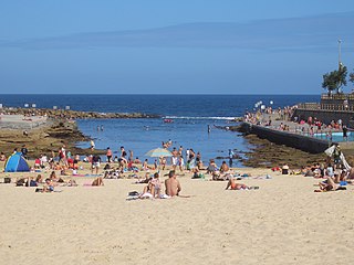
South Coogee is a coastal suburb in south-eastern Sydney, in the state of New South Wales, Australia. South Coogee is located 9 kilometres south-east of the Sydney central business district, in the local government area of the City of Randwick and part of the Eastern Suburbs region.

The Sydney tramway network served the inner suburbs of Sydney, Australia from 1879 until 1961. In its heyday, it was the largest in Australia, the second largest in the Commonwealth of Nations, and one of the largest in the world. The network was heavily worked, with about 1,600 cars in service at any one time at its peak during the 1930s . Patronage peaked in 1945 at 405 million passenger journeys. It had a maximum street mileage of 181 miles (291 km), in 1923.

The Spot is a locality in south-eastern Sydney, New South Wales, Australia. The Spot is located in the south-eastern part of the suburb of Randwick, around the intersection of Perouse Road and St Pauls Street. It is a vibrant part of Randwick and consists of a collection of shops, restaurants, cafes and a cinema.

Anzac Parade is a major road in the south-eastern suburbs of Sydney, Australia. It included part of the marathon during the 2000 Summer Olympics, and the blue line denoting the marathon's path still exists today.
Rockingham Road is a major road between Fremantle and Kwinana in the southern suburbs of Perth. It is allocated National Route 1 – part of Australia's national Highway 1 – between Stock Road in Munster and its southern terminus in Kwinana.

Hampton Road is the main road entering the City of Fremantle from the south. It is named after John Stephen Hampton, the Governor of Western Australia from 1862 to 1868. It continues into Ord Street at the north east corner of Fremantle Prison at Knutsford Street.
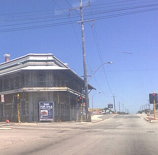
Cockburn Road is a major road in the southern suburbs of Perth, which connects Fremantle and Kwinana. While it is for the most part a coastal road, much of its length travels through heavy industrial areas. However, a number of other facilities can be found on the road—the Woodman Point Recreation Reserve which includes camping and accommodation facilities, the Beeliar Regional Park and the Cockburn International Raceway.

North Coogee is a coastal, western suburb of Perth, Western Australia, located within the City of Cockburn. The suburb is immediately to the north of Coogee, which takes its name from the lake, Lake Coogee, in the area, which translates to "Body of water" in the native Aboriginal Nyoongar language. Originally this lake was named Lake Munster after Prince William, the Earl of Munster, and later King William IV. The aboriginal name Kou-gee was recorded in 1841 by Thomas Watson and has been variously spelt Koojee, Coojee and Coogee.

Wylie's Baths is an heritage-listed tidal swimming pool located near Coogee Beach, in the Eastern Suburbs of Sydney, New South Wales, Australia. The baths are noted for holding the first Australian Swimming Championships and for being one of the first swimming baths for mixed gender swimming in Australia. The Baths were added to the New South Wales State Heritage Register on 14 November 2003 and are also classified by the National Trust of Australia.

Nugal Hall is an heritage-listed Gothic Revival style former residence, convalescent hospital and embassy and now residence located at 16-18 Milford Street, in the Sydney suburb of Randwick in the City of Randwick local government area of New South Wales, Australia. It was designed by Mortimer Lewis and Oswald H. Lewis and built during 1853. The property is privately owned. It was added to the New South Wales State Heritage Register on 2 April 1999 and on the Register of the National Estate.


