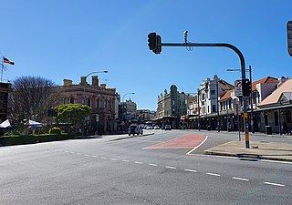
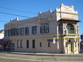
King Street is the central thoroughfare of the suburb of Newtown in Sydney, Australia. The residents of the area, including a higher-than-average concentration of students, LGBT people and artists, are most visible on this street, sealing Newtown's reputation as Sydney's premier hub of subcultures. The street can be divided geographically into two sections, North and South. King Street is particularly notable for the many picturesque Victorian era and Edwardian era commercial buildings that line the street.
King Street forms part of the Princes Highway officially and is allocated route A36.[1]
History
Like Parramatta Road, King Street is believed to follow the line of ancient Aboriginal track that led from the Sydney Cove area south-west across to Botany Bay. Prior to European settlement, the local Aboriginal population kept the Sydney area well cleared with regular low-level fires. Colonial officer Watkin Tench recorded that during the early years of the colony, the area beyond the settlement was, in effect, open parkland, and that it was possible to walk easily across country from Sydney Cove to Botany Bay.
From the late 19th century onwards, King Street developed into a thriving retail precinct. After its initial prosperity, it became run down for much of the 20th century, when Newtown was a low-income blue-collar suburb, often denigrated as a slum; at the crucial time when Victorian era buildings were being demolished elsewhere, Newtown was too unfashionable to make development profitable. By this sheer luck, King Street, as a whole, is the best-preserved Victorian era high street in Sydney, and despite gentrification since the late 20th century, development controls ensure that this will not change.
King Street was served by a busy tramway until the system's closure in 1957 (Keenan 1979). The buildings are still predominantly late Victorian, to early Federation, although there are some art deco buildings as well.
North King Street
North King Street, running east-north-east to west-south-west from the University of Sydney (where it joins with City Road) to Newtown railway station at the junction with Enmore Road, is a very busy thoroughfare, with heavy vehicular and pedestrian traffic the rule rather than the exception. This is the stretch that most people associate with King Street, featuring a profusion of restaurants, cafés and pubs, alongside bookshops, fashion stores and homeware retailers.
South King Street
South-end of King Street, with the iconic brickworks chimneys of Sydney Park
South King Street, often known as "the Paris end", running southwards from Newtown railway station to St Peters railway station, is by contrast the down-market section, with slightly less traffic. Businesses that have been established in this stretch of King Street include cafés, antique shops and assorted small businesses. The southern end of South King Street, between Alice Street and St Peters railway station, features three theatres (New Theatre, King Street Theatre and Sydney Independent Theatre Company) and three pubs (Union Hotel, Botany View Hotel and Sydney Park Hotel).
In popular culture
The 1985 song "King St" by John Kennedy's Love Gone Wrong references the street and name-checks various local landmarks and characters of the time including the Coles' New World supermarket (which occupied the building which is now the Dendy Cinemas), "The Wire Man" (a local eccentric who collected wire coat hangers and scrap metal), Maurice's Lebanese restaurant (still extant) and The Hub cinema (which was operating as a pornographic cinema at the time). The music video features extensive footage of King St as it looked in 1985.
The 2006 Australian drama film Candy starring Heath Ledger and Abbie Cornish features Advance Loan Office on King Street, in the scene where the female lead prostitutes herself for money to fund her and her boyfriend's drug addiction.
Newtown, a suburb of Sydney's inner west, is located approximately four kilometres south-west of the Sydney central business district, straddling the local government areas of the City of Sydney and Inner West Council in the state of New South Wales, Australia.
Bondi Junction is an eastern suburb of Sydney, in the state of New South Wales, Australia. It is 6 kilometres east of the Sydney central business district and is part of the local government area of Waverley.
George Street is a street in the central business district of Sydney.
Broadway is a 700-metre (2,300 ft) road in inner city Sydney, New South Wales, Australia. The road constitutes the border between the suburbs of Ultimo and Chippendale. Broadway is also an urban locality.
Macquarie Street is a street in the central business district of Sydney in New South Wales, Australia. Macquarie Street extends from Hyde Park at its southern end to the Sydney Opera House at its northern end. Apart from connecting these two major landmarks, the key government institutions of the state of New South Wales are all located on this street.
Tempe is a suburb in the Inner West of Sydney, in the state of New South Wales, Australia. Tempe is located 9 kilometres south of the Sydney central business district in the local government area of Inner West Council.
Alexandria is an inner-city suburb of Sydney, New South Wales, Australia. Alexandria is located 5 kilometres south of the Sydney central business district and is part of the local government area of the City of Sydney. The postcode is 2015.
Erskineville is an inner-city suburb of Sydney, in the state of New South Wales, Australia. It is located 6 kilometres south west of the Sydney central business district and is part of the local government area of the City of Sydney. Erskineville is a diverse suburb homing to a wide variety of ethnicity from its varying Southeast Europe and Aboriginal community. Erskineville is colloquially known as Erko.
Enmore is a suburb in the Inner West of Sydney, in the state of New South Wales, Australia. Enmore is located 5 kilometres (3.1 mi) south-west of the Sydney central business district and is part of the local government area of Inner West Council. Like Newtown, Enmore is mostly comprises Victorian era buildings, namely in its commercial area, that provide a hint of the suburb's rich cultural heritage.
The Sydney tramway network served the inner suburbs of Sydney, Australia from 1879 until 1961. In its heyday, it was the largest in Australia, the second largest in the Commonwealth of Nations, and one of the largest in the world. The network was heavily worked, with about 1,600 cars in service at any one time at its peak during the 1930s . Patronage peaked in 1945 at 405 million passenger journeys. Its maximum street trackage totalled 291 km in 1923.
City Road is a busy 1-kilometre (0.62 mi) thoroughfare located in Sydney, New South Wales, Australia. City Road runs south from a junction with Broadway and Parramatta Road, through the University of Sydney and becomes King Street as it enters the suburb of Newtown.
College Street is a 700-metre (2,300 ft) major street in the central business district of Sydney in New South Wales, Australia. From north to south, it runs from east of Queens Square and St James station to start at the junction of the Prince Albert, St Marys, and Art Gallery roads and runs to Whitlam Square, at Liverpool Street. The street gets its name from a college on the street, St. Mary’s Cathedral College. The street runs beside the eastern border of Hyde Park, and is lined by the Australian Museum, Sydney Grammar School, Cook and Phillip Park Aquatic and Fitness Centre, St Mary's Cathedral, and Australian International College.
Cleveland Street is a busy thoroughfare near the central business district of Sydney in New South Wales, Australia. From west to east, it runs from City Road in Chippendale, across the railway lines between Central and Redfern stations and east through Surry Hills, crossing the Eastern Distributor and South Darling Street, to terminate at Anzac Parade, Centennial Park. The street is named after Captain Cleveland, an officer of the 73rd regiment.
Railway Square is a plaza at the southern end of the Sydney central business district, New South Wales, Australia, formed by the confluence of Broadway, Lee Street, Pitt Street and George Street. The square itself is a very busy intersection and is the site of a large bus terminus. The University of Technology, Central railway station and the now-closed Kent Brewery are adjacent to Railway Square.
Australian non-residential architectural styles are a set of Australian architectural styles that apply to buildings used for purposes other than residence and have been around only since the first colonial government buildings of early European settlement of Australia in 1788.
King Street is a street in the central business district of Sydney in New South Wales, Australia. It stretches from King Street Wharf and Lime Street near Darling Harbour in the west, to Queens Square at St. James railway station in the east.
Since the 1980s, the area surrounding the Sydney inner west suburb of Newtown, New South Wales (NSW), Australia—including the suburbs of Newtown, Enmore, Erskineville, Camperdown and St Peters—has been known for its wide range of prominent graffiti and street art on walls. The public visual art in the Newtown area consists of a variety of styles and methods of execution, including large-scale painted murals, hand-painted political slogans, hand-painted figurative designs, spray painted semi-abstract designs "tags"), and other stylistic developments such as stencil art and street poster art, "Yarn bombing", and sculptural items cast from plaster and other materials.
Edwardian architecture is a Neo-Baroque architectural style that was popular in the British Empire during the Edwardian era (1901–1910). Architecture up to the year 1914 may also be included in this style.
Newtown Tram Depot is a heritage-listed former tram depot in King Street, Newtown, City of Sydney, New South Wales, Australia. It was part of the Sydney tram network. The tram depot and Newtown railway station were jointly added to the New South Wales State Heritage Register on 2 April 1999.
This page is based on this Wikipedia article Text is available under the CC BY-SA 4.0 license; additional terms may apply. Images, videos and audio are available under their respective licenses.