Corydon Township, Warren County, Pennsylvania

Last updated
Corydon Township
Map of Corydon Township, Warren County, Pennsylvania Highlighted.png
Former location of Corydon Township in modern-day Warren County
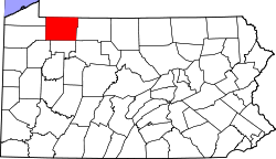
Map of Pennsylvania highlighting Warren County.svg
Location of Warren County in Pennsylvania
Coordinates: 41°47′0″N79°1′0″W / 41.78333°N 79.01667°W / 41.78333; -79.01667
CountryUnited States
State Pennsylvania
County Warren
Settled1827
Time zone UTC-4 (EST)
  Summer (DST) UTC-5 (EDT)
Area code 814

Corydon Township is a defunct township in Warren County, Pennsylvania in the United States. The township was merged in 1964 into Mead Township.

Contents

History

Warren County was formed on March 12, 1800 out of Allegheny County, with the original township of Brokenstraw being formed in that October from everything in the county west of the Allegheny River and Conewango Creek; Conewango Township was formed in March 1808 and consisted of the unincorporated eastern half of Warren County. [1] On March 26, 1846, a portion of Corydon Township in McKean County was set off for Warren County. [2] [3]

Philip Tome, a native of Dauphin County, was the first settler in Corydon in 1827 and for many years was interpreter for Seneca chiefs Cornplanter and Governor Blacksnake. The Buffalo, New York, and Philadelphia Railroad opened in 1882 and brought growth to the community, bringing in stores, a hotel, a stave-mill, a pulp company, a spoke factory, a handle factory, a saw mill, a shingle mill, and various other industries. [4]

Population of (West) Corydon peaked in 1900; while it received a modest boost in population in the 1890s, it did not experience the massive boom and bust that its neighboring townships along the Allegheny did. It was in a state of persistent decline through the first half of the 20th century and had already shrunk to less than a third of its peak by 1960. Construction of the Kinzua Dam caused the resulting Allegheny Reservoir to submerge the remaining communities in Corydon Township. The little remaining land that remained above water was annexed to Mead Township in 1964. [5]

Geography

Corydon Township was located on a strip of land in the extreme northeastern corner of Warren County, and was bounded by the Town of South Valley, New York on the north; (East) Corydon in McKean County on the east, Kinzua Township to the south; and the Allegheny River on the west. [6] A ferry service (Webb's Ferry) connected Corydon with Elk Township, Warren County, Pennsylvania across the river. The ferry's western terminus in Elk Township remains in use, maintained by the Allegheny National Forest.

Related Research Articles

<span class="mw-page-title-main">Allegheny River</span> River in Pennsylvania and New York, United States

The Allegheny River is a 325-mile-long (523 km) headwater stream of the Ohio River that is located in western Pennsylvania and New York in the United States. It runs from its headwaters just below the middle of Pennsylvania's northern border, northwesterly into New York, then in a zigzag southwesterly across the border and through Western Pennsylvania to join the Monongahela River at the Forks of the Ohio at Point State Park in Downtown Pittsburgh, Pennsylvania.

<span class="mw-page-title-main">Warren County, Pennsylvania</span> County in Pennsylvania, United States

Warren County is a county in the Commonwealth of Pennsylvania. As of the 2020 census, the population was 38,587. Its county seat is Warren. The county was established in 1800 from parts of Allegheny and Lycoming counties; attached to Crawford County until 1805 and then to Venango County until Warren was formally established in 1819.

<span class="mw-page-title-main">McKean County, Pennsylvania</span> County in Pennsylvania, United States

McKean County is a rural county in the Commonwealth of Pennsylvania. As of the 2020 census, the population was 40,432. Its county seat is Smethport. The county was created in 1804 and organized in 1826. It was named in honor of former Pennsylvania Governor and Declaration of Independence signer Thomas McKean.

Coldspring is a town in Cattaraugus County, New York, United States. As of the 2020 census it had a population of 661. It is located in the southwest part of the county, west of the city of Salamanca.

South Valley is a town in Cattaraugus County, New York, United States. The population was 250 at the 2020 census. The name is derived from the town's geographical attributes.

<span class="mw-page-title-main">Elk Township, Warren County, Pennsylvania</span> Township in Pennsylvania, United States

Elk Township is a township in Warren County, Pennsylvania, United States. The population was 482 at the 2020 census, down from 520 at the 2010 census. 551 at the 2000 census.

<span class="mw-page-title-main">Mead Township, Pennsylvania</span> Township in Pennsylvania, United States

Mead Township is a township in Warren County, Pennsylvania, United States. The population was 1,300 at the 2020 census, down from 1,386 at the 2010 census and 1,555 at the 2000 census.

<span class="mw-page-title-main">Warren, Pennsylvania</span> City in Pennsylvania, United States

Warren is a city in and the county seat of Warren County, Pennsylvania, United States, located along the Allegheny River. The population was 9,404 at the 2020 census. It is home to the headquarters of the Allegheny National Forest and the Cornplanter State Forest. It is also the headquarters for the Chief Cornplanter Council, the oldest continuously chartered Boy Scouts of America Council, and the catalog company Blair. Warren is the principal city of the Warren micropolitan area.

<span class="mw-page-title-main">Cornplanter</span> Seneca war chief and diplomat (1732–1836)

John Abeel III known as Gaiänt'wakê or Kaiiontwa'kon in the Seneca language and thus generally known as Cornplanter, was a Dutch-Seneca chief warrior and diplomat of the Seneca people. As a war chief, Cornplanter fought in the American Revolutionary War on the side of the British. After the war Cornplanter led negotiations with the United States and was a signatory of the Treaty of Fort Stanwix (1784), the Treaty of Canandaigua (1794), and other treaties. He helped ensure Seneca neutrality during the Northwest Indian War.

<span class="mw-page-title-main">Kinzua Bridge State Park</span> State park in Pennsylvania, United States

Kinzua Bridge State Park is a 339-acre (137 ha) Pennsylvania state park near Mount Jewett, in Hamlin and Keating Townships, McKean County, Pennsylvania in the United States. The park lies between U.S. Route 6 and Pennsylvania Route 59, along State Route 3011 just east of the Allegheny National Forest.

<span class="mw-page-title-main">Kinzua Dam</span> Dam on the Allegheny River, Allegheny National Forest, Warren County, Pennsylvania, US

The Kinzua Dam, on the Allegheny River in Warren County, Pennsylvania, is one of the largest dams in the United States east of the Mississippi River. It is located within the Allegheny National Forest.

<span class="mw-page-title-main">New York State Route 280</span> State highway in Cattaraugus County, New York, US

New York State Route 280 (NY 280) is an 11.59-mile (18.65 km) long north–south state highway in rural Cattaraugus County, New York, in the United States. The southern terminus of the route is at the Pennsylvania state line in South Valley, where it becomes Pennsylvania Route 346 (PA 346). The northern terminus is at exit 18 on the Southern Tier Expressway in Coldspring, west of Salamanca. NY 280 follows both the eastern edge of the Allegheny Reservoir and the western boundary of Allegany State Park for its entire length.

<span class="mw-page-title-main">Pennsylvania Route 59</span> State highway in Pennsylvania, US

Pennsylvania Route 59 is a 39-mile (63 km) long state highway located in northwest Pennsylvania. The route links Warren to Smethport, terminating at U.S. Route 6 at both ends. PA 59 acts as a northerly bypass to US 6, directly connecting Warren and Smethport while US 6 dips south to serve Kane and Mount Jewett.

<span class="mw-page-title-main">Kinzua Creek</span> River in Pennsylvania, United States

Kinzua Creek is a 26.5-mile (42.6 km) tributary of the Allegheny River that is located in McKean County, Pennsylvania in the United States.

Kinzua may refer to:

<span class="mw-page-title-main">Pennsylvania Route 346</span> State highway in Pennsylvania, US

Pennsylvania Route 346 (PA 346) is a 34.177-mile (55.003 km) state highway located in Warren and McKean counties in Pennsylvania, United States The western terminus is at the New York state line in the Allegheny National Forest, where it becomes New York State Route 280 (NY 280). The eastern terminus is at an intersection with PA 446 in Eldred. The route is mostly a two-lane road that passes through rural areas in the northern part of McKean County. PA 346 passes through the city of Bradford, where it has a concurrency with the U.S. Route 219 (US 219) freeway.

<span class="mw-page-title-main">Allegheny Reservoir</span> Reservoir in Pennsylvania and New York

The Allegheny Reservoir is a reservoir along the Allegheny River in Pennsylvania and New York, USA. It was created in 1965 by the construction of the Kinzua Dam along the river. Lake Perfidy comes from Peter La Farge's ballad "As Long as the Grass Shall Grow," recorded by Johnny Cash on his album Bitter Tears: Ballads of the American Indian, which alleged that the reservoir's existence violates the 1794 agreement between Seneca chief Cornplanter and George Washington.

<span class="mw-page-title-main">Kinzua Township, Warren County, Pennsylvania</span> Township in Pennsylvania, United States

Kinzua Township was a township in Warren County, Pennsylvania in the United States. The township was merged in 1963 into Mead Township.

The Pennsylvania State Game Lands Number 30 are Pennsylvania State Game Lands in McKean County in Pennsylvania in the United States providing hunting, bird watching, and other activities.

References

  1. Schenck, p. 259.
  2. Hottenstein, p. 127.
  3. Schenck, p. 266.
  4. Warren County Historical Society History of Warren County Pennsylvania Schenck 1887
  5. Hoover, William N (2006). Kinzua: From Cornplanter to the Corps. Lincoln, Nebraska: iUniverse. p. 12. ISBN   0-595-82483-8.
  6. Schenck, p. 559.

Sources