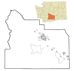
Cowiche, Washington | |
---|---|
Coordinates: 46°40′11″N120°42′44″W / 46.6698469°N 120.7122935°W [1] | |
Country | United States |
State | Washington |
County | Yakima |
Elevation | 1,749 ft (533 m) |
Population (2020) | |
• Total | 535 |
Time zone | UTC-8 (Pacific (PST)) |
• Summer (DST) | UTC-7 (PDT) |
ZIP code | 98923 |
Area code | 509 |
GNIS feature ID | 1512121 [2] |
Cowiche (pronounced Cow-witch-ee) is a census-designated place and unincorporated community northwest of Yakima, Washington, near the eastern foothills of the Cascade Mountain range, in central Washington State (US). Cowiche, sometimes spelled Cowychee, is said to mean "footbridge between the valley and the mountains." According to the 2020 census, [3] the town had a population of 535, which is an increase from 428 at 2010. [4]
The first inhabitants of the area were the Tkai'waichash-hlama, a band or tribe of Native American people who lived along Cowiche Creek. The area was settled in the late nineteenth century by farmers who relied upon crops that did not require irrigation, such as wheat, barley, rye, and grazing cattle. Homesteading in Cowiche was difficult since fields had to be cleared of volcanic rock before they could be tilled and there was little rainfall in summer. In 1906, construction began on the Tieton Irrigation Project, a division of the broader Yakima Project. Irrigation water became available in 1907, and shortly thereafter, orchards began to replace wheatfields.
Cowiche, along with the neighboring town of Tieton, is served by the Highland School district Highland School District / Homepage. The community takes great pride in its high school sports programs, and in 1988 their varsity men's basketball team won the Washington State A division championship. The boys soccer team also won the state championship in 2006, 2007 & 2015
Most people in the area are involved in agriculture. Cowiche, like much of the Yakima Valley, is known for its apple crops.
The Yakima River is a tributary of the Columbia River in south central and eastern Washington state, named for the indigenous Yakama people. Lewis and Clark mention in their journals that the Chin-nâm pam called the river Tâpe têtt, possibly from the French tape-tête, meaning "head hit". The length of the river from headwaters to mouth is 214 miles (344 km), with an average drop of 9.85 feet per mile (1.866 m/km). It is the longest river entirely in Washington state.
Benton County is a county in the south-central portion of the U.S. state of Washington. As of the 2020 census, its population was 206,873. The county seat is Prosser, and its most populous city is Kennewick. The Columbia River demarcates the county's north, south, and east boundaries.
Yakima is a city in, and the county seat of, Yakima County, Washington, United States, and the state's 11th most populous city. As of the 2020 census, the city had a total population of 96,968 and a metropolitan population of 256,728. The unincorporated suburban areas of West Valley and Terrace Heights are considered a part of greater Yakima.
Yakima County is a county in the U.S. state of Washington. As of the 2020 census, its population was 256,728. The county seat and most populous city is Yakima. The county was formed out of Ferguson County in January 1865 and is named for the Yakama tribe of Native Americans.
Kittitas County is a county located in the U.S. state of Washington. At the 2020 census, its population was 44,337. Its county seat and largest city is Ellensburg. The county was created in November 1883 when it was carved out of Yakima County. Kittitas County comprises the Ellensburg, Washington, Micropolitan Statistical Area.
Prosser is a city in and the county seat of Benton County, Washington, United States. Situated along the Yakima River, it had a population of 6,062 at the 2020 census.
Thorp is an unincorporated community and census-designated place (CDP) in Kittitas County, Washington, United States. In 2015, the population was 317 according to statistics compiled by Data USA.
Sunnyside is a city in Yakima County, Washington, United States. The population was 16,375 at the 2020 census, making it the second largest city in Yakima County.
Tieton is a city in Yakima County, Washington, United States. The population was 1,389 at the 2020 census.
Wapato is a town in Yakima County, Washington, United States. The population was 4,607 at the 2020 census. It has a Hispanic majority.
Zillah is a city in Yakima County, Washington, United States, with a population of 3,179 as of the 2020 census.
Paradise Valley is a census-designated place (CDP) in Humboldt County, Nevada, United States, near the Santa Rosa Ranger District of Humboldt National Forest. It is located at the northern terminus of Nevada State Route 290, about 19 miles (31 km) northeast of U.S. Highway 95 and a total of 40 miles (64 km) north of Winnemucca. The town is located in a broad valley, with the Santa Rosa Range of mountains just to the northwest. At the 2010 census, the population of the CDP was 109.
Ripley is a census-designated place community in east Riverside County. It is located along State Route 78 (SR78) between Palo Verde and Blythe. The area is mostly agricultural lands irrigated by Colorado River water. The elevation is 249 feet (76 m). The population was 692 at the 2010 census.
Yakima Valley is the first American Viticultural Area (AVA) established within Washington state, gaining the recognition on May 4, 1983. Within the vast Columbia Valley AVA, Yakima Valley appellation cultivates more than 53,000 acres (21,448 ha) giving the region the largest concentration of wineries and vineyards in the state. The most widely planted varietals in the area are Chardonnay, Riesling, Merlot, Cabernet Sauvignon, Pinot gris, and Syrah. Nearly 40% of Washington's annual wine production is made from Yakima Valley grapes. In addition to grapes, the Yakima Valley is also home to several fruit orchards growing apples, cherries, nectarines, peaches, pears and plums. Around the town of Zillah, there is the Zillah Fruit Loop driving tour through the area's orchards and vineyards. The area is also home to nearly 80% of the US hop production.
The Naches River is a tributary of the Yakima River in central Washington in the United States. Beginning as the Little Naches River, it is about 75 miles (121 km) long. After the confluence of the Little Naches and Bumping River the name becomes simply the Naches River. The Naches and its tributaries drain a portion of the eastern side of the Cascade Range, east of Mount Rainier and northeast of Mount Adams. In terms of discharge, the Naches River is the largest tributary of the Yakima River.
The Tieton River is a tributary of the Naches River, in Yakima County, Washington in the United States.
Rimrock Lake is a lake along the course of the Tieton River, in Yakima County, Washington state, US.
The Rattlesnake Hills, also known as Rattlesnake Ridge, is a 16-mile (26 km) long anticline mountain ridge in Yakima County and Benton County in the U.S. state of Washington. It should not be confused with the much smaller Rattlesnake Ridge located near the west end of Ahtanum Ridge just south of Yakima, Washington and west of Union Gap, Washington. The highest point in the hills is the 3,629 feet (1,106 m) Lookout Summit, which surpasses the more well-known Rattlesnake Mountain by approximately 100 ft (30 m). The Rattlesnake Hills are part of the Yakima Fold Belt of east-tending long ridges formed by the folding of Miocene Columbia River basalt flows.
Gromore is an unincorporated community in Yakima County, Washington, United States, located approximately one mile west of Yakima. Gromore was an agricultural area located at the terminus of a Yakima Valley Transportation Company interurban line.
Tampico is a census-designated place and unincorporated community in Yakima County, Washington, United States, located approximately eighteen miles west of Yakima on Ahtanum Creek. The population was 312 at the 2010 United States Census.