
Damariscotta is a town in Lincoln County, Maine, United States. The population was 2,218 at the 2010 census. Damariscotta is the oyster capital of New England. A popular tourist destination, the towns of Damariscotta and Newcastle are linked by the Main Street bridge over the Damariscotta River, forming the "Twin Villages". The name Damariscotta is an Indian name meaning "river of little fish".

Newcastle is a town in Lincoln County, Maine, United States. The population was 1,752 at the 2010 census. The village of Newcastle is located in the eastern part of the town, on the Damariscotta River. Together with the village of Damariscotta linked by the Main Street bridge, they form the Twin Villages.

Whaleback Shell Midden is a shell midden, or dump, consisting primarily of oyster shells located on the east side of the Damariscotta River in Maine, United States. It is preserved as a Maine state historic site and was included as part of the Damariscotta Oyster Shell Heaps listed on the National Register of Historic Places in 1969. Other shell middens are located on the estuary in both Damariscotta and Newcastle. The middens in this area were formed over about 1,000 years between 200 BC to AD 1000.

Fig Island, also known as 38CH42, is an archaeological site on the Atlantic Coast of South Carolina, consisting of three shell rings. Shell rings are curved shell middens wholly or partially surrounding a clear central area or plaza. The site includes one of the largest and most complex shell rings in North America, and one of the best preserved circular shell rings.
Indian Mound Park, also known as Shell Mound Park or Indian Shell Mound Park, is a park and bird refuge located on the northern shore of Dauphin Island, a barrier island of Mobile County, Alabama in the United States. In addition to the many birds which visit, a wide variety of botanical species contribute to the natural offerings. The site is historically significant due to the presence of prehistoric Indian shell middens, mounds composed of discarded oyster shells. The park was added to the National Register of Historic Places on August 14, 1973. It is administered by the Alabama Department of Conservation and Natural Resources.
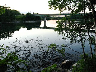
The Damariscotta River is a 19.0-mile-long (30.6 km) tidal river in Lincoln County, Maine, that empties into the Atlantic Ocean. Damariscotta is an old Abenaki word for "river of many fishes". There are 2,500-year-old oyster shell middens (heaps) along the banks of the Damariscotta River, which occupies a drowned river valley leading to the Gulf of Maine, a large embayment of the Atlantic Ocean.

The Tchefuncte Site (16ST1) is an archaeological site that is a type site for the prehistoric Tchefuncte culture period. The name is pronounced Che-funk'tuh. It is located in the southeast section of Fontainebleau State Park near Mandeville, St. Tammany Parish, Louisiana.

St. Andrew's Church is a historic Episcopal church at 11 Glidden Street in Newcastle, Maine. Built in 1883, it was the first example of cottage Gothic Revival church in the country, and the first US design of English architect Henry Vaughan, a major proponent of the style. It was listed on the National Register of Historic Places in 1976.
The Main Street Historic District encompasses the historic commercial center of Damariscotta, Maine. Although the community was settled in the 18th century, most of its downtown area dates to the second half of the 19th century due to an 1845 fire. Lining Main Street east of the Damariscotta River, the downtown has a well-preserved collection of commercial, residential, and civic structures from the period. The district was added to the National Register of Historic Places in 1979, and enlarged in 2001.

The Caratunk Falls Archeological District is a complex of prehistoric and historic archaeological sites in the Solon, Maine area. First identified in the 1960s as archaeologically significant, the site was mapped by state archaeologists in the early 1980s. At that time it was the single largest complex of archaeological significance in interior Maine, encompassing a period of human activity from the Archaic to the European contact period. The 16-acre (6.5 ha) area was listed on the National Register of Historic Places in 1986.

The Fernald Point Prehistoric Site is an archaeological site in Acadia National Park on Mount Desert Island on the central coast of Maine. The principal feature of the site is a shell midden, whose excavation has yielded both historic artifacts and evidence of human occupation to at least 1000 BCE. The site was listed on the National Register of Historic Places in 1978.
The Goddard Site is a prehistoric archaeological site in Brooklin, Maine. The site is notable for the large number of stone artifacts found, most of which were sourced at locations well removed from the area, and for the presence of worked copper artifacts. It is most widely known as the claimed location at which the Maine penny, a Norse coin dating to the reign of Olaf Kyrre, was found. The site was listed on the National Register of Historic Places in 1979.
The town of North Haven, Maine is an island community located principally on North Fox Island in southern Penobscot Bay, separated from its mouth by Vinalhaven. The Fox Islands were the subject of an intensive archaeological survey in the 1970s, in which more than 49 sites of interest were identified in North Haven. Eight of these were deemed significant enough to be listed on the National Register of Historic Places; the most significant of these, the Turner Farm Site, was a site exhibiting evidence of year-round occupation during at least three time periods in prehistory.
The Von Mach Site is an archaeological site in Brooksville, Maine. Located on the south bank of the Bagaduce River opposite Castine, the principal feature of the site is a large shell midden, yielding evidence of a long period of human habitation. When excavated by pioneering Maine archaeologist Warren K. Moorehead in the 1920s, he described one of the ceramic finds at this site among the most finely decorated he had found anywhere on the New England coast. The site was listed on the National Register of Historic Places in 1989.
Flye Point 2, also designated Site 42.43 by the Maine Archaeological Survey, is a prehistoric archaeological site in Brooklin, Maine. This site includes a large shell midden, and has yielded evidence of human habitation, including "pit house" features, with an estimated occupation time of 1000 CE. The midden is one of the largest of its type on the coast of eastern Maine. It was listed on the National Register of Historic Places in 1985.
The Atkinson-Koskinen Site, designated 45.13 by the Maine Archaeological Survey, is a prehistoric archaeological site in or near Steuben, Maine. Its main feature is a non-shell refuse midden, a rarity on the coast of eastern Maine. Along with the Goddard Site in Brooklin, it is important in analyzing land use and subsistence patterns during the Late Ceramic period. The site was listed on the National Register of Historic Places in 1984.
The Devils Head Site, designated Site 97.10 by the Maine Archaeological Survey, is a prehistoric and historic archaeological site in Calais, Maine. Located on the banks of the St. Croix River, it is a shell midden site with evidence of multiple periods of human habitation, from the Middle Ceramic Period to the Late Contact Period and beyond. With its location near Saint Croix Island, the site of an early French settlement in 1604, the site's finds may provide insight into early French-Native relations in the area. The site was listed on the National Register of Historic Places in 2006.
Archeological Site No. 29-64 is a prehistoric archaeological site in Islesboro, Maine. The site encompasses a shell midden, in which are embedded the remains of semi-subterranean pit-house structures. It is one of the best-preserved examples of this type in northeastern North America. The site was listed on the National Register of Historic Places in 1982.
Dodge Point Preserve is a state-owned conservation area in Newcastle, Maine. It includes 500 acres (200 ha) of land, with 8,000 feet (2,400 m) of frontage on the Damariscotta River. Public facilities include hiking trails and a dock. The preserve was established in 1989, and is managed by a partnership between the state and the Damariscotta River Association.


