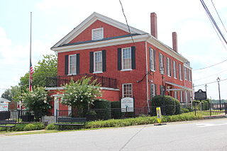
Dawsonville is a city in and the county seat of Dawson County, Georgia, United States. The population was 2,536 at the 2010 census, up from 619 in 2000.
Charlotte County is the southwest-most county of New Brunswick, Canada.

Madawaska County, also known as the "New Brunswick Panhandle", is located in northwestern New Brunswick, Canada. Over 90% of the county's population speaks French. Its Francophone population are known as "Brayons." Forestry is the major industry in the county.

Restigouche County is located in north-central New Brunswick, Canada. The county is named for the Restigouche River which flows through the county and is famous for its salmon pools, which have attracted wealthy American and Canadian tourists to the region's summer colonies for decades. Forestry dominates the local economy.

Westmorland County is a county in New Brunswick, a province of Canada. It is in the south-eastern part of the province. It contains the fast-growing commercial centre of Moncton and its northern and eastern suburbs. Also located in the county are the university town of Sackville and the tourist destination of Shediac.

York County is located in west-central New Brunswick, Canada. The county contains the provincial capital, Fredericton. Outside the city, farming and forestry are two major industries in the county, which is bisected by the Saint John River. The Southwest Miramichi River flows through the northern section of the county.

Campobello Island is the largest and only inhabited island in Campobello, a civil parish in southwestern New Brunswick, Canada, near the border with Maine, United States. The island's permanent population in 2021 was 949. It is the site of the Roosevelt Campobello International Park and of Herring Cove Provincial Park.
Dawsonville may refer to:

Route 17, commonly known as the Stewart Highway, is 148 kilometres (92 mi) long and runs from the Canada–US border in Saint-Leonard to Route 11 in Glencoe near Campbellton. Saint-Quentin and Kedgwick are other towns along the route. With the exception of those towns, the highway runs almost entirely through sparsely populated forest land. It is the only highway connecting northwestern New Brunswick with the province's north shore. It is named in honour of David A. Stewart.
New Maryland is a suburban bedroom village of Fredericton in central New Brunswick, Canada; located directly south of Fredericton, south of Route 2 and Route 101. As of 2021, the population was 4,153, which means it is large enough to become a "town". New Maryland is one of the wealthiest communities in New Brunswick as it has a median household income of over $110,000, the highest of any municipality in the province.

Shippagan is a Canadian town within Shippegan Parish, Gloucester County, New Brunswick.
Belledune is a Canadian village that straddles both Restigouche County and Gloucester County, New Brunswick.
Kedgwick is a Canadian incorporated rural community in northern New Brunswick, Canada. On 1 January 2023, Kedgwick annexed a large area including the local service districts of St. Jean Baptiste – Menneval and White's Brook, with parts of two others; revised census figures have not been released.

Saint-Léonard is a community in Madawaska County, New Brunswick, Canada. It held town status prior to 2023.

New Brunswick is one of Canada's three provinces of the Maritimes, and the only officially bilingual province in the country. The provincial Department of Finance estimates that the province's population in 2006 was 729,997 of which the majority is English-speaking but with a substantial French-speaking minority of mostly Acadian origin.

Eldon is a civil parish in Restigouche County, New Brunswick, Canada.
Upsalquitch is an unincorporated community in Restigouche County, New Brunswick, Canada. The town is located in the northern part of the province, near the Quebec border, south of Route 17.
