The National Oceanic and Atmospheric Administration is an American scientific agency within the United States Department of Commerce that focuses on the conditions of the oceans, major waterways, and the atmosphere.

Fog is a visible aerosol consisting of tiny water droplets or ice crystals suspended in the air at or near the Earth's surface. Fog can be considered a type of low-lying cloud, usually resembling stratus, and is heavily influenced by nearby bodies of water, topography, and wind conditions. In turn, fog has affected many human activities, such as shipping, travel, and warfare.

The Golden Gate is a strait on the west coast of North America that connects San Francisco Bay to the Pacific Ocean. It is defined by the headlands of the San Francisco Peninsula and the Marin Peninsula, and, since 1937, has been spanned by the Golden Gate Bridge. The entire shoreline and adjacent waters throughout the strait are managed by the Golden Gate National Recreation Area.

The weather satellite is a type of satellite that is primarily used to monitor the weather and climate of the Earth. Satellites can be polar orbiting, covering the entire Earth asynchronously, or geostationary, hovering over the same spot on the equator.

The Great Smog of London, or Great Smog of 1952, was a severe air-pollution event that affected the British capital of London in early December 1952. A period of cold weather, combined with an anticyclone and windless conditions, collected airborne pollutants—mostly arising from the use of coal—to form a thick layer of smog over the city. It lasted from Friday 5 December to Tuesday 9 December 1952, and then dispersed quickly when the weather changed.

NOAA Weather Radio is an automated 24-hour network of VHF FM weather radio stations in the United States that broadcast weather information directly from a nearby National Weather Service office. The routine programming cycle includes local or regional weather forecasts, synopsis, climate summaries, synopsis or zone/lake/coastal waters forecasts. During severe conditions the cycle is shortened into: hazardous weather outlooks, short-term forecasts, special weather statements or tropical weather summaries. It occasionally broadcasts other non-weather related events such as national security statements, natural disaster information, environmental and public safety statements sourced from the Federal Communications Commission's (FCC) Emergency Alert System. NOAA Weather Radio uses automated broadcast technology that allows for the recycling of segments featured in one broadcast cycle seamlessly into another and more regular updating of segments to each of the transmitters. It also speeds up the warning transmitting process.
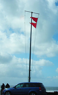
Weather services issue a gale warning for maritime locations currently or imminently experiencing winds of Gale Force on the Beaufort scale. Gale warnings allow mariners to take precautionary actions to ensure their safety at sea or to seek safe anchorage and ride out the storm on land. Though usually associated with deep low-pressure areas, winds strong enough to catalyze a gale warning can occur in other conditions too, including from anticyclones, or high-pressure systems, in the continental interior. The winds are not directly associated with a tropical cyclone.
A Lake Effect Snow Advisory was issued by the National Weather Service of the United States when lake effect snow may pose a hazard or is life-threatening. The snow must be completely caused by a convective snow development over a lake and not by a low pressure system. The criteria for this advisory vary from area to area.
In meteorology, visibility is a measure of the distance at which an object or light can be clearly discerned. It is reported within surface weather observations and METAR code either in meters or statute miles, depending upon the country. Visibility affects all forms of traffic: roads, sailing and aviation. Meteorological visibility refers to transparency of air: in dark, meteorological visibility is still the same as in daylight for the same air.

Airport weather stations are automated sensor suites which are designed to serve aviation and meteorological operations, weather forecasting and climatology. Automated airport weather stations have become part of the backbone of weather observing in the United States and Canada and are becoming increasingly more prevalent worldwide due to their efficiency and cost-savings.
In National Weather Service (NWS) terminology, a Hazardous Weather Outlook is a weather statement issued to provide information of potential severe weather events within the next seven days. The outlook may include information about potential severe thunderstorms, heavy rain or flooding, winter weather, extremes temperatures.
National Weather Service Chicago, currently based in Romeoville, Illinois, is a weather forecast office responsible for monitoring weather conditions for 23 counties in Northern Illinois, the Chicago metropolitan area and Northwest Indiana. The Army Signal Service established the first federal weather office in the region in Chicago on October 15, 1870. During May 1894 the Chicago Weather Bureau was given a new forecast area extending from the Great Lakes region all the way to the Rocky Mountains. The current National Weather Service Chicago is located in Romeoville and is in charge of issuing local forecasts and weather warnings for the Chicago area. It is one of only two National Weather Service offices in Illinois, the other being National Weather Service Central Illinois in Lincoln, Illinois. The National Weather Service Chicago forecast office is located adjacent to the Lewis University Airport in Romeoville, Illinois.
The National Weather Service Weather Forecast Office New Orleans/Baton Rouge, Louisiana is a National Weather Service office located in Slidell, Louisiana.
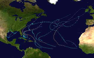
The 2019 Atlantic hurricane season is an ongoing event in the annual formation of tropical cyclones in the Northern Hemisphere and also the fourth consecutive year of above-average and damaging seasons dating back to 2016, although many of the storms were weak and short-lived. With 17 named storms, the season is tied with 2017 and 1936 for the fifth-most named storms since reliable records began in 1851. The season officially began on June 1 and will end on November 30. These dates historically describe the period each year when most tropical cyclones form in the Atlantic basin and are adopted by convention. However, tropical cyclogenesis is possible at any time of the year, as demonstrated by the formation of Subtropical Storm Andrea on May 20, marking the record fifth year in a row where a tropical or subtropical cyclone developed before the official start of the season, breaking the previous record of four years set in 1951–1954. This was also the second year in a row in which no tropical cyclones formed during the month of June.

NOAAS Whiting, was an American survey ship that was in commission in the National Oceanic and Atmospheric Administration (NOAA) from 1970 to 2003. Previously, she had been in commission in the United States Coast and Geodetic Survey from 1963 to 1970 as USC&GS Whiting.

The 2018 Pacific hurricane season produced the highest accumulated cyclone energy value on record in the basin. With 23 named storms, it was the fourth-most active season on record, tied with 1982. The season also featured seven landfalls, six of which occurred in Mexico. The season officially began on May 15 in the eastern Pacific, and on June 1 in the central Pacific; they both ended on November 30. These dates conventionally delimit the period of each year when most tropical cyclones form in the Pacific basin. However, tropical cyclone formation is possible at any time of the year, as illustrated when the first tropical depression formed on May 10, five days prior to the official start of the season.

The 2019 Pacific hurricane season is an ongoing event in the annual cycle of tropical cyclone formation, in which tropical cyclones form in the eastern Pacific Ocean. The season officially began on May 15 in the East Pacific Ocean, and on June 1 in the Central Pacific; they will both end on November 30. These dates conventionally delimit the period of each year when most tropical cyclones form in the Pacific basin. However, the formation of tropical cyclones is possible at any time of the year. The season had a slow start, with no tropical cyclones forming in the basin during the month of May for the first time since 2016, and the first time that no storms formed before the month of June since 2011. The season became the latest-starting Pacific hurricane season on record since reliable records began in 1971, with the first tropical depression forming on June 25. For the first time since 1973, no hurricanes formed in the basin in the month of August.
An Ashfall Advisory is a weather advisory issued by the National Weather Service of the United States. Ashfall Advisories are issued when there is a likely future or present occurrence of ash rain caused by a large plume of suspended airborne ash, typically caused by large fires or volcanic activity. The National Weather service map color is Dark Grey.

