This article contains too many or overly lengthy quotations for an encyclopedic entry. (December 2019) |
A Particularly Dangerous Situation (PDS) is a type of enhanced wording first used by the Storm Prediction Center (SPC), a national guidance center of the United States National Weather Service, for tornado watches and eventually expanded to use for other severe weather watches and warnings by local NWS forecast offices. It is issued at the discretion of the forecaster composing the watch or warning and implies that there is an enhanced risk of very severe and life-threatening weather, usually a major tornado outbreak or (much less often) a long-lived, extreme derecho event, but possibly another weather hazard such as an exceptional flash flood or fire. [1] [2]
PDS watches are quite uncommon; less than 3% of watches issued by the SPC from 1996 to 2005 were PDS watches, or an average of 24 each year. [3] When a PDS watch is issued, there are often more PDS watches issued for the same weather system, even on the same day during major outbreaks, so the number of days per year that a PDS watch is issued is significantly lower.
The short history of the origin of the option of issuing a tornado watch with the enhanced Particularly Dangerous Situation (PDS) wording occurred during the winter of 1981-82 when the Severe Local Storms (SELS) unit transitioned to a more flexible method of issuing weather products. Ed Ferguson, Deputy Director of the National Severe Storms Forecast Center (NSSFC), suggested to Lead Forecaster Jack Hales that the guidance center could provide an opportunity to give more resolution to the tornado watch product. Hales suggested the PDS option to identify areas where, a few times each year, conditions are most likely to aid in the development of large and intense tornadoes. The first PDS tornado watch was issued by Robert H. Johns for the April 2, 1982 tornado outbreak across the southern and central Great Plains. [4]
While historically applied only to severe thunderstorm, tornado and flash flood watches (i.e., Severe Local Storm "polygonal" events), PDS wording could theoretically be applied to other types of weather watches (such as winter storm, high wind, hurricane, or fire weather watches) when an enhanced threat for such conditions exists. These watches have generally (but not always) been issued during a high risk or an upper-end moderate risk either of severe storms from the SPC's convective outlooks or of flash flooding from the Weather Prediction Center (WPC)'s Excessive Rainfall Outlooks.
On April 24, 2011, the National Weather Service Weather Forecast Office in Memphis, Tennessee issued the first PDS flash flood watch to highlight the threat for widespread, significant and potentially life-threatening flash flooding due to repeated rounds of severe thunderstorms.
On December 19, 2017 and August 3, 2018, the National Weather Service Weather Forecast Office in Reno, Nevada issued PDS Red Flag Warnings to highlight the threat for potentially life-threatening fire danger due to strong gusty winds and low humidity.
PDS flash flood watches are issued when there is a higher-than-normal risk of widespread, life-threatening flash flooding. These watches are issued by local NWS Weather Forecast Offices, not the Storm Prediction Center.
Below is the first PDS Flash Flood Watch, which was issued by the National Weather Service Forecast Office in Memphis, Tennessee on April 24, 2011, as mentioned above. [5]
URGENT - IMMEDIATE BROADCAST REQUESTED FLOOD WATCH NATIONAL WEATHER SERVICE MEMPHIS TN 239 PM CDT SUN APR 24 2011 ...VERY HEAVY RAINFALL THROUGH THE MIDDLE OF THIS WEEK WILL LIKELY LEAD TO SIGNIFICANT...WIDESPREAD FLASH FLOODING... ...THIS IS A PARTICULARLY DANGEROUS SITUATION... A BOUNDARY WILL CONTINUE TO REMAIN STATIONARY ACROSS SOUTHERN MISSOURI INTO KENTUCKY THROUGH MONDAY. REPEATED ROUNDS OF THUNDERSTORMS WILL TRACK ALONG THE FRONT BRINGING HEAVY RAINFALL. THEN A LOW PRESSURE SYSTEM WILL TRACK ALONG IT INTO MISSOURI AND PUSH THE FRONT FURTHER SOUTH TO ALONG THE I-40 CORRIDOR MONDAY NIGHT THROUGH TUESDAY NIGHT. THIS WILL SHIFT THE HEAVY RAIN AXIS FURTHER SOUTH TO ALONG AND JUST NORTH OF THE I-40 CORRIDOR. A SECOND LOW PRESSURE SYSTEM WILL TRACK ALONG THE NEWLY STALLED BOUNDARY AND SET OFF ADDITIONAL TRAINING THUNDERSTORMS LATE TUESDAY NIGHT AND WEDNESDAY. THE FINAL COLD FRONT WILL PASS THROUGH LATE WEDNESDAY AFTERNOON...ENDING THE PERSISTENT HEAVY RAINFALL. ARZ026>028-035-036-048-049-058-MSZ001>014-TNZ003-004-019>021- 048>055-088>092-250400- /O.NEW.KMEG.FF.A.0007.110426T0000Z-110428T0000Z/ /00000.0.ER.000000T0000Z.000000T0000Z.000000T0000Z.OO/ CRAIGHEAD-POINSETT-MISSISSIPPI-CROSS- CRITTENDEN-ST. FRANCIS- LEE AR-PHILLIPS-DESOTO-MARSHALL-BENTON MS-TIPPAH-ALCORN- TISHOMINGO-TUNICA-TATE-PRENTISS- COAHOMA-QUITMAN-PANOLA-LAFAYETTE- UNION-WEAKLEY-HENRY-DYER-GIBSON-CARROLL-LAUDERDALE-TIPTON-HAYWOOD- CROCKETT-MADISON-CHESTER-HENDERSON- DECATUR-SHELBY-FAYETTE- HARDEMAN-MCNAIRY-HARDIN- INCLUDING THE CITIES OF...JONESBORO...HARRISBURG...BLYTHEVILLE... WYNNE...WEST MEMPHIS...FORREST CITY...HELENA... SOUTHAVEN... OLIVE BRANCH...CORINTH...IUKA...TUNICA...[[Booneville, Mississippi|BOONEVILLE]]... CLARKSDALE...BATESVILLE...OXFORD...NEW ALBANY... MARTIN... DRESDEN...PARIS...DYERSBURG...HUMBOLDT...MILAN...HUNTINGDON... COVINGTON...JACKSON...LEXINGTON...BARTLETT...GERMANTOWN... COLLIERVILLE...MEMPHIS...MILLINGTON...SOMERVILLE... BOLIVAR... SAVANNAH 239 PM CDT SUN APR 24 2011 ...FLASH FLOOD WATCH IN EFFECT FROM MONDAY EVENING THROUGH WEDNESDAY EVENING... THE NATIONAL WEATHER SERVICE IN MEMPHIS HAS ISSUED A * FLASH FLOOD WATCH FOR PORTIONS OF EAST ARKANSAS...NORTH MISSISSIPPI AND WEST TENNESSEE...INCLUDING THE FOLLOWING AREAS...IN EAST ARKANSAS...CRAIGHEAD...CRITTENDEN...CROSS... LEE...MISSISSIPPI...PHILLIPS...POINSETT AND ST. FRANCIS. IN NORTH MISSISSIPPI...ALCORN...BENTON...COAHOMA...DESOTO... LAFAYETTE...MARSHALL...PANOLA...PRENTISS...QUITMAN...TATE... TIPPAH...TISHOMINGO...TUNICA AND UNION. IN WEST TENNESSEE... CARROLL...CHESTER...CROCKETT...DECATUR...DYER...FAYETTE... GIBSON...HARDEMAN...HARDIN...HAYWOOD...HENDERSON...HENRY... LAUDERDALE...MADISON...MCNAIRY...SHELBY...TIPTON AND WEAKLEY. * FROM MONDAY EVENING THROUGH WEDNESDAY EVENING. * THIS IS A PARTICULARLY DANGEROUS SITUATION * TOTAL RAINFALL AMOUNTS OF 5 TO 8 INCHES ARE EXPECTED ALONG AND NORTH OF I-40 WITH 2 TO 5 INCHES EXPECTED SOUTH OF I-40. LOCALLY HIGHER AMOUNTS ARE LIKELY. * RAINFALL AMOUNTS SUCH AS THESE MAY LEAD TO WIDESPREAD... SIGNIFICANT...AND LIFE THREATENING FLASH FLOODING. THIS EVENT MAY BE AS SEVERE AS THE MAY 1–2, 2010 FLOODING IN PLACES. FLASH FLOODING OF CITIES...RURAL AREAS...RIVERS...AND SMALL STREAMS ARE POSSIBLE. PRECAUTIONARY/PREPAREDNESS ACTIONS... A FLASH FLOOD WATCH MEANS THAT CONDITIONS MAY DEVELOP THAT LEAD TO FLASH FLOODING. FLASH FLOODING IS A VERY DANGEROUS SITUATION. YOU SHOULD MONITOR LATER FORECASTS AND BE PREPARED TO TAKE ACTION SHOULD FLASH FLOOD WARNINGS BE ISSUED. && $$ ARZ008-009-017-018-MOZ113-115-TNZ001-002-250400- /O.EXT.KMEG.FF.A.0006.000000T0000Z-110428T0000Z/ /00000.0.ER.000000T0000Z.000000T0000Z.000000T0000Z.OO/ RANDOLPH-CLAY-LAWRENCE-GREENE-DUNKLIN-PEMISCOT-LAKE-OBION- INCLUDING THE CITIES OF...WALNUT RIDGE...PARAGOULD...KENNETT... CARUTHERSVILLE...UNION CITY 239 PM CDT SUN APR 24 2011 ...FLASH FLOOD WATCH NOW IN EFFECT THROUGH WEDNESDAY EVENING... THE FLASH FLOOD WATCH IS NOW IN EFFECT FOR * PORTIONS OF EAST ARKANSAS...SOUTHEAST MISSOURI AND WEST TENNESSEE...INCLUDING THE FOLLOWING AREAS...IN EAST ARKANSAS... CLAY...GREENE...LAWRENCE AND RANDOLPH. IN SOUTHEAST MISSOURI... DUNKLIN AND PEMISCOT. IN WEST TENNESSEE...LAKE AND OBION. * THROUGH WEDNESDAY EVENING. * THIS IS A PARTICULARLY DANGEROUS SITUATION * ADDITIONAL RAINFALL AMOUNTS OF 6 TO 9 INCHES ARE EXPECTED. LOCALLY HIGHER AMOUNTS ARE LIKELY. THIS...IN COMBINATION OF THE 2 TO 4 INCHES THAT HAVE ALREADY FALLEN MAY LEAD TO TOTAL RAINFALL AMOUNTS IN EXCESS OF 12 INCHES IN MANY LOCATIONS. * RAINFALL AMOUNTS SUCH AS THESE WILL LIKELY LEAD TO WIDESPREAD... SIGNIFICANT...AND LIFE THREATENING FLASH FLOODING. THIS EVENT MAY BE AS SEVERE AS THE MAY 1-2 2010 FLOODING IN MANY PLACES. FLASH FLOODING OF CITIES...RURAL AREAS...RIVERS...AND SMALL STREAMS ARE POSSIBLE. PRECAUTIONARY/PREPAREDNESS ACTIONS... A FLASH FLOOD WATCH MEANS THAT CONDITIONS MAY DEVELOP THAT LEAD TO FLASH FLOODING. FLASH FLOODING IS A VERY DANGEROUS SITUATION. YOU SHOULD MONITOR LATER FORECASTS AND BE PREPARED TO TAKE ACTION SHOULD FLASH FLOOD WARNINGS BE ISSUED. && $$ BORGHOFF
PDS flash flood warnings are issued when there is a higher than normal risk of widespread, life-threatening flash flooding. Like PDS Flash Flood Watches, they are issued by the local NWS Weather Forecast Offices, rather than the Storm Prediction Center. Recently, they have been issued as PDS Flash Flood Emergencies, most notably by the National Weather Service offices in Houston, TX and Corpus Christi, TX.
This warning was issued in the morning of May 30, 2018 by the National Weather Service Forecast Office in Greenville-Spartanburg, South Carolina, while Subtropical Storm Alberto was affecting the area. It also contains the Flash Flood Emergency phrase, which further underscores the risk of life-threatening flash flooding. [6]
NCC111-301630- /O.EXT.KGSP.FF.W.0034.000000T0000Z-180530T1630Z/ 00000.0.ER.000000T0000Z.000000T0000Z.000000T0000Z.OO Flash Flood Statement National Weather Service Greenville-Spartanburg SC 626 AM EDT WED MAY 30 2018 ...FLASH FLOOD EMERGENCY CONTINUES FOR AREAS DOWNSTREAM OF LAKE TAHOMA DUE TO POTENTIAL IMMINENT FAILURE OF TAHOMA DAM...MANDATORY EVACUATIONS UNDERWAY... Flash Flood Warning REMAINS IN EFFECT Until 1230 PM WEDNESDAY EDT FOR CENTRAL MCDOWELL COUNTY * At 611 AM EDT, Emergency Management is reporting that the risk of imminent failure remains at Lake Tahoma Dam and mandatory evacuations remain in effect. This emergency evacuation was issued at the recommendation of dam engineers who remain on scene to monitor the dam. Lake Tahoma Dam is currently in a Level 1 or Imminent Failure Condition. This condition will continue until the engineers have the opportunity to thoroughly inspect the dam during daylight hours. THIS IS AN EXTREMELY DANGEROUS SITUATION! MANDATORY EVACUATIONS are underway for ALL residents and businesses downstream of Lake Tahoma along Buck Creek and along the Catawba River from Buck Creek and Lake Tahoma Rd (NC 80) to the mouth of Lake James. To save your life, please heed all county evacuation notices and take action to leave the vicinity immediately! Repeating, this is a FLASH FLOOD EMERGENCY for McDowell County for areas downstream of Lake Tahoma and Lake Tahoma Dam to the mouth of Lake James along the Catawba River. This is a PARTICULARLY DANGEROUS SITUATION. SEEK HIGHER GROUND NOW! * Repeating, mandatory evacuations remain underway from Lake Tahoma Dam at Lake Shore Dr down Lake Tahoma Rd (NC 80) to the confluence of the Catawba River near US 70, Resistoflex Rd, and Riverside Park. Residences and businesses along US 70 from Lake Tahoma Rd to US 221 Business near Garden Creek, as well as areas along Hankins Rd. to the mouth of Lake James are included in the mandatory evacuation. LEAVE NOW! * Evacuees are being asked to seek shelter at the Glenwood Baptist Church, the Old Fort Baptist Church, or the YMCA in Marion near McDowell Hospital. * Some locations that are experiencing flooding include... Pleasant Gardens, northwest Marion, and Lake James. * The excessive rainfall over the warned area has caused numerous mud slides and additional mud slides are possible near steep terrain. The mud slide can consist of rock, mud, vegetation and other loose materials and are very powerful. PRECAUTIONARY/PREPAREDNESS ACTIONS... Move to higher ground NOW. This is an extremely dangerous and life-threatening situation. Do NOT attempt to travel unless you are fleeing an area subject to flooding or under an evacuation order. Most flood deaths occur in vehicles. Do not attempt to cross water-covered roadways, bridges, or low-level crossings. Only a few inches of rapidly flowing water can carry away your vehicle. It is not worth the risk. Please TURN AROUND, DON`T DROWN. The floodwave along Buck Creek above and below Lake Tahoma will increase the risk of landslides, especially in areas where slides have occurred in the past. Be especially alert if you are near a stream, especially at the base of a mountain or in a cove. Watch for loose-moving soil and rocks or a sudden increase in streamflow. Leave the area quickly if this is observed. When driving along roads where the terrain is steep or rocky, watch and listen for falling rocks, mud, trees and other debris. && LAT...LON 3574 8207 3572 8205 3574 8202 3574 8198 3570 8196 3570 8200 3567 8206 3573 8211 $$ JMP
PDS high wind warnings are issued by the National Weather Service when non-convective winds are expected to be especially damaging or dangerous to people and property, beyond what would be expected of a typical high wind warning.
The warning below was issued by the National Weather Service in Salt Lake City, Utah on September 8, 2020 for an extreme downslope wind event in Salt Lake City and the northern Wasatch Front. [7]
URGENT - WEATHER MESSAGE National Weather Service Salt Lake City UT 911 AM MDT Tue Sep 8 2020 UTZ002-003-082315- /O.CON.KSLC.HW.W.0006.000000T0000Z-200909T1500Z/ Northern Wasatch Front-Salt Lake and Tooele Valleys- Including the cities of Ogden, Bountiful, and Salt Lake City 911 AM MDT Tue Sep 8 2020 ...HIGH WIND WARNING REMAINS IN EFFECT UNTIL 9 AM MDT WEDNESDAY... ...THIS IS A PARTICULARLY DANGEROUS SITUATION.... * WHAT...East winds 30 to 45 mph with gusts in excess of 70 mph are expected. Wind gusts as high as 98 mph near Farmington, Centerville and the mouth of Weber Canyon have been reported this morning. This is a particularly dangerous situation. * WHERE...Salt Lake and Tooele Valleys and Northern Wasatch Front. * WHEN...Until 9 AM MDT Wednesday. * IMPACTS...High winds may move loose debris, damage property and cause power outages. Travel will be difficult especially for high profile vehicles. The most impacted travel routes are expected to be along the I-15 corridor between Salt Lake City and Layton, the Legacy Parkway, the US 89 corridor in Davis and Weber Counties, and Foothill Drive. * ADDITIONAL DETAILS...Stay inside! Flying debris and numerous falling trees may be deadly. PRECAUTIONARY/PREPAREDNESS ACTIONS... People are urged to secure loose objects that could be blown around or damaged by the wind. && $$
PDS red flag warnings are issued by the National Weather Service to inform the public that there is an unusually high threat of wildland fire combustion, and rapid spread of wildfires, due to very dry fuels, very low humidity levels, and strong winds.
The PDS Red Flag Warning below was issued by the National Weather Service in Reno, Nevada on December 19, 2017. [8]
On August 3, 2018, the National Weather Service in Reno, Nevada issued another PDS red flag warning to communicate the threat of life-threatening fire danger due to strong gusty winds and low humidity.
BULLETIN - EAS ACTIVATION REQUESTED National Weather Service Reno NV 140 PM PST Tue Dec 19 2017 CAZ273-201500- /O.CON.KREV.FW.W.0017.171220T0300Z-171221T0300Z/ Mono and Eastern Alpine Counties- 140 PM PST Tue Dec 19 2017 WILDFIRE EMERGENCY FOR PORTIONS OF ALPHINE AND MONO COUNTIES The National Weather Service in Reno has issued a *Red Flag Warning for... Fire Zone 273 Affecting Mono and Eastern Alpine Counties UNTIL 7 PM PST WEDNESDAY FOR GUSTY WINDS AND LOW HUMIDITY FOR MONO COUNTY SOUTH OF MONO LAKE... ...THIS IS A PARTICULARLY DANGEROUS SITUATION... AFFECTED AREA...Fire Zone 273 Mono and Eastern Alpine Counties. Winds...Southwest 25 to 40 mph with gusts up to 70 mph late tonight into Wednesday morning. The winds will shift to the north by early Wednesday afternoon with speeds of 20 to 30 mph and gusts to 55 mph. Location and timing of strongest wind gusts...The strongest wind gusts will be along the 395 corridor tonight into Wednesday morning. Wednesday afternoon the strongest gusts will be in the Owens and Chalfant Valleys. Humidity...As low as 10 to 20% tonight and again late Wednesday afternoon. Brief recovery near or above 50% is possible late Wednesday morning. Duration...10 to 15 hours, locally up to 20 hours. Impacts...The combination of gusty winds and low humidity can cause fire to rapidly grow in size and intensity. PRECAUTIONARY/PREPAREDNESS ACTIONS... This is a particularly dangerous situation with low humidity and very high winds. New fires will grow rapidly out of control, in some cases people may not be able to evacuate safely in time should a fire approach. Avoid outdoor activities that can cause a spark near dry vegetation, such as yard work, target shooting, or campfires. THIS IS A PARTICULARLY DANGEROUS SITUATION... SEEK SHELTER NOW. Follow local fire restrictions. Check weather.gov/reno for updates and livingwithfire.info for preparedness tips. REPEATING: THIS IS A PARTICULARLY DANGEROUS SITUATION TAKE COVER NOW THIS IS A WILDFIRE EMERGENCY
PDS severe thunderstorm watches are issued when there is a higher than normal risk of severe thunderstorm winds capable of major structural damage (in addition to large hail and perhaps a few isolated tornadoes), usually due to a strong and persistent derecho. These watches are very rare (accounting an average of only two each year), as the risk for tornadoes must remain low enough to not warrant a tornado watch (a normal tornado watch would be issued if the tornado risk is significant alongside the extreme wind threat). [3]
This PDS Severe Thunderstorm Watch shown below was issued by the Storm Prediction Center in Norman, Oklahoma on July 19, 2019 for an extreme wind threat in northern Wisconsin. [9]
SEL5 URGENT - IMMEDIATE BROADCAST REQUESTED Severe Thunderstorm Watch Number 525 NWS Storm Prediction Center Norman OK 550 PM CDT Fri Jul 19 2019 The NWS Storm Prediction Center has issued a * Severe Thunderstorm Watch for portions of Much of north central and northeastern Wisconsin Lake Michigan * Effective this Friday afternoon and Saturday morning from 550 PM until 100 AM CDT. ...THIS IS A PARTICULARLY DANGEROUS SITUATION... * Primary threats include... Widespread damaging winds and scattered significant gusts to 105 mph expected Scattered large hail and isolated very large hail events to 2.5 inches in diameter possible A few tornadoes likely SUMMARY...An intense supercell cluster in northwestern Wisconsin is expected to evolve into a damaging bow echo that will accelerate east-southeastward across northern/northeastern Wisconsin this evening. The storm environment will favor swaths of high-end, destructive outflow winds potentially exceeding 100 mph. Tornadoes will also be possible with embedded circulations, as well as large hail in the next few hours with lingering supercell structures. The severe thunderstorm watch area is approximately along and 55 statute miles north and south of a line from 70 miles west northwest of Wausau WI to 30 miles northeast of Manitowoc WI. For a complete depiction of the watch see the associated watch outline update (WOUS64 KWNS WOU5). PRECAUTIONARY/PREPAREDNESS ACTIONS... REMEMBER...A Severe Thunderstorm Watch means conditions are favorable for severe thunderstorms in and close to the watch area. Persons in these areas should be on the lookout for threatening weather conditions and listen for later statements and possible warnings. Severe thunderstorms can and occasionally do produce tornadoes. && OTHER WATCH INFORMATION...CONTINUE...WW 523...WW 524... AVIATION...A few severe thunderstorms with hail surface and aloft to 2.5 inches. Extreme turbulence and surface wind gusts to 90 knots. A few cumulonimbi with maximum tops to 650. Mean storm motion vector 29050. ...Thompson
PDS Special marine warnings are issued by the National Weather Service to inform mariners of weather conditions that present a considerable threat to life and property.
On April 19, 2018, the Baltimore/Washington, D.C. forecast office upgraded a Special Marine Warning to PDS status as a gust front approached Chesapeake Bay. [10]
National Weather Service Baltimore MD/Washington DC 1138 AM EDT THU APR 19 2018 ANZ537-191700- /O.CON.KLWX.MA.W.0020.000000T0000Z-180419T1700Z/ 1138 AM EDT THU APR 19 2018 ...A SPECIAL MARINE WARNING REMAINS IN EFFECT UNTIL 100 PM EDT... For the following areas... Tidal Potomac from Cobb Island MD to Smith Point VA... At 1137 AM EDT, a gust front was located near Quantico Marine Base, moving southeast at 25 knots. Numerous wind gusts of 35 to 45 knots have been observed with this line. HAZARD...Wind gusts 34 knots or greater. SOURCE...Radar indicated. IMPACT...Boaters in small craft could be thrown overboard by suddenly higher winds and waves capsizing their vessel. Locations impacted include... Yeocomico River... Breton Bay... Point Lookout... Coltons Point... Saint Clements Bay... Coles Point... Mouth Of The Potomac River... Saint George Island... White Point Beach... Tall Timbers... and Piney Point. PRECAUTIONARY/PREPAREDNESS ACTIONS... This is a particularly dangerous situation. Sudden onset of gale force winds can cause even experienced mariners to capsize. Capsizing in cold water is especially dangerous and can quickly result in hypothermia. If you haven't already done so, move to safe harbor now! && LAT...LON 3797 7641 3801 7647 3802 7651 3807 7654 3811 7660 3815 7661 3817 7676 3817 7685 3826 7686 3825 7684 3823 7660 3821 7657 3814 7652 3806 7633 3801 7629 3791 7627 TIME...MOT...LOC 1537Z 310DEG 27KT 3871 7777 3813 7848 HAIL...0.00in WIND...>34kts $$ DHOF
PDS special weather statements are usually for issued by the NWS for hazards that do not have a specific code of their own, and pose an exceptionally high risk of damage and loss of life.
The PDS Special Weather Statement below was issued by the National Weather Service in Buffalo, New York on December 11, 2013, regarding extreme amounts of lake effect snow to impact the defined area.[ citation needed ] The same office issued a PDS Special Weather Statement for hurricane-force winds forecast to hit the Buffalo area on February 24, 2019.
SPECIAL WEATHER STATEMENT NATIONAL WEATHER SERVICE BUFFALO NY 255 PM EST WED DEC 11 2013 NYZ006>008-112200- OSWEGO-JEFFERSON-LEWIS- INCLUDING THE CITIES OF...OSWEGO...WATERTOWN...LOWVILLE 255 PM EST WED DEC 11 2013 ...EXTREMELY HEAVY LAKE EFFECT SNOW TO CONTINUE THROUGH THE EVENING COMMUTE... A BAND OF VERY INTENSE LAKE EFFECT SNOW EXTENDING FROM BETWEEN SANDY CREEK AND ADAMS ALONG I-81...EASTWARD TO LOWVILLE AND CROGHAN WILL CONTINUE THROUGH THE AFTERNOON. OTHER AREAS IMPACTED BY THIS SNOW BAND INCLUDE BUT ARE NOT LIMITED TO MONTAGUE...MARTINSBURG...HIGHMARKET...TURIN...SANDY CREEK...LACONA...PULASKI...LOWVILLE AND LYONS FALLS. THIS BAND WILL DRIFT SLIGHTLY NORTH OVER THE NEXT COUPLE OF HOURS. SNOWFALL RATES OF 3 TO 5 INCHES PER HOUR CAN BE EXPECTED WITHIN THE MOST INTENSE LAKE BANDS. IN ADDITION...WEST WINDS BETWEEN 15 TO 30 MPH WILL RESULT IN CONSIDERABLE BLOWING AND DRIFTING SNOW...REDUCING VISIBILITIES TO NEAR ZERO AT TIMES MAKING FOR WHITE OUT CONDITIONS. ...THIS IS A PARTICULARLY DANGEROUS SITUATION... THIS WILL PRODUCE TREACHEROUS TRAVEL CONDITIONS ACROSS THE TUG HILL...INTERSTATE 81 FROM PULASKI TO ADAMS...AND ALONG STATE ROUTE 12 FROM TURIN TO LOWVILLE. TRAVEL ACROSS THESE AREAS WILL BE NEARLY IMPOSSIBLE THIS AFTERNOON...AND IS HIGHLY DISCOURAGED. $$ JAM
PDS tornado watches are issued when there is a higher than normal risk of multiple strong to violent tornadoes – especially those that are predicted to be long-track in nature, with path lengths of more than 20 miles – in the watch area (usually amounting to damage consistent with EF4 or EF5 tornadoes at maximum), in addition to including significant wind and hail damage. This enhanced wording in a Tornado Watch is meant to alert the public of the potential for very life-threatening severe weather. While there are no set criteria for a PDS watch to be issued, they are usually issued when the potential exists for a major tornado outbreak. These types of tornado watches represent about 90% of PDS watches issued by the Storm Prediction Center. PDS Tornado Watches are often issued on high risk days for severe weather.
The PDS Tornado Watch shown below was issued on May 20, 2019. [11]
SEL7 URGENT - IMMEDIATE BROADCAST REQUESTED Tornado Watch Number 197 NWS Storm Prediction Center Norman OK 1235 PM CDT Mon May 20 2019 The NWS Storm Prediction Center has issued a * Tornado Watch for portions of West Texas including much of the Panhandle * Effective this Monday afternoon and evening from 1235 PM until 800 PM CDT. ...THIS IS A PARTICULARLY DANGEROUS SITUATION... * Primary threats include... Numerous tornadoes expected with a few intense tornadoes likely Widespread large hail and scattered very large hail events to 4 inches in diameter expected Widespread damaging wind gusts to 70 mph likely SUMMARY...Intense tornadic supercell thunderstorms are expected to develop across west Texas as the eastern half of the Texas Panhandle. In addition to the risk of strong tornadoes, very large hail and damaging winds are likely in the strongest cells. The tornado watch area is approximately along and 55 statute miles east and west of a line from 50 miles east northeast of Amarillo TX to 35 miles east of Big Spring TX. For a complete depiction of the watch see the associated watch outline update (WOUS64 KWNS WOU7). PRECAUTIONARY/PREPAREDNESS ACTIONS... REMEMBER...A Tornado Watch means conditions are favorable for tornadoes and severe thunderstorms in and close to the watch area. Persons in these areas should be on the lookout for threatening weather conditions and listen for later statements and possible warnings. && OTHER WATCH INFORMATION...CONTINUE...WW 196... AVIATION...Tornadoes and a few severe thunderstorms with hail surface and aloft to 4 inches. Extreme turbulence and surface wind gusts to 60 knots. A few cumulonimbi with maximum tops to 600. Mean storm motion vector 24035. ...Hart
The most recent PDS Tornado Watches were Tornado Watch 106 and 110 on April 12, 2020 covering parts of Alabama, Mississippi, Arkansas, Louisiana and the Florida Panhandle.
PDS tornado warnings are currently issued on an experimental basis by the 38 National Weather Service Weather Forecast Offices within the Central Region. [13] The criteria for a PDS warning are when a tornado on the ground has been spotted or confirmed, or a significant tornado is expected based on radar signatures. While the intention of this experimental warning may be to replace the loosely defined tornado emergency, PDS tornado warnings are structured as the second highest level of tornado warning within the Impact Based Warning system (an experiment – which also includes tags within warning products illustrating radar indications or physical observations of tornadoes, and damage potential – participated by the 33 Weather Forecast Offices within the Central Region, as well as eight additional offices within the Western, Eastern and Southern regions that began utilizing the system in the spring of 2014 [14] ); a tornado emergency, the highest warning level, is used within the United States for destructive tornadoes approaching more densely populated areas. These are the first warnings issued with PDS wording, and like PDS flash flood watches, are issued by local forecast offices. [15] [16]
Below is an example of a PDS Tornado Warning from the Rochelle/Fairdale, IL Tornado on April 9, 2015 In Taylorville a EF-3 Was confirmed by every confirmer And NWS In Lincoln issued a PDS Tornado Warning in December 1st 2018
153 WFU553 KLOT 092358 TORLOT ILC007-037-141-201-100045 /O.NEW.KLOT.TO.W.0008.150409T2358Z-150410T0045Z/ BULLETIN - EAS ACTIVIATION REQUESTED TORNADO WARNING National Weather Service Lincoln IL 658 PM CST DEC 1 2018 TORNADO EMERGENCY FOR TAYLORVILLE AND CENTRAL CHRISTIAN COUNTY.... THE NATIONAL WEATHER SERVICE IN LINCOLN ISSUED A.. * TORNADO WARNING FOR... Central Christian County in south Central illinois * UNTIL 6:00 PM CST * AT 5:15 PM CST...A CONFIRMED LARGE AND DESTRUCTED TORNADO OBSERVED WAS LOCATED NEAR TAYLORVILLE ...OR JUST NORTHWEST OF SPRINGFIELD MOVING NORTHEAST AT MPH. TORNADO EMERGENCY FOR TAYLORVILLE AND CENTRAL CHRISTIAN COUNTY.. THIS IS A PARTICULARLY DANGEROUS SITUATION. TAKE COVER NOW! HAZARD...DEADLY TORNADO. SOURCE...Radar confirmed and Weather Spotters and Public and Media and Emergency Management and Law Enforcement confirmed tornado. IMPACT...YOU ARE IN A LIFE THREATENING SITUATION. FLYING DEBRIS MAY BE DEADLY TO THOSE CAUGHT WITHOUT SHELTER. MOBILE HOMES WILL BE DESTROYED. CONSIDERABLE DAMAGE TO HOMES...BUSINESSES AND VEHICLES IS LIKELY AND COMPLETE DESTRUCTION IS POSSIBLE. * THE TORNADO WILL BE NEAR... STONINGTON AROUND 520 PM CST. SPRINGFIELD AROUND 525 PM CST THIS TORNADO WILL REMAIN IN OVER RUTAL AREAS OF CENTRAL CHRISTIAN COUNTY PRECAUTIONARY/PREPAREDNESS ACTIONS... TO REPEAT.. A LARGE AND EXTREMELY DANGEROUS TORNADO IS ON THE GROUND. TAKE IMMEDIATE TORNADO PRECAUTIONS. THIS IS AN EMERGENCY SITUATION TORRENTIAL RAINFALL IS OCCURRING AND MAY HIDE THE TORNADO SEEK SHELTER NOW. IF YOUR OUTSIDE OR A MOBILE HOME MOVE TO THE CLOSEST SUBSTANTIAL SHELTER AND PROTECT YOURSELF FROM FLYING DEBRIS. TORNADOES ARE DIFFICULT OR HARD TO COMFIRM AT NIGHT DO NOT WAIT OF HEAR THE TORNADO TAKE COVER NOW. && LAT...LON 4190 8914 4198 8920 4225 8894 4207 8870 TIME...MOT...LOC 2357Z 229DEG 38KT 4199 8909 TORNADO...OBSERVED TORNADO DAMAGE THREAT...CATASTROPIC HAIL...1.50 LOT.--890*---NEW*$$$$$$ MILLER $$$$# IZZI[17]
PDS wind chill warnings are issued when there is an enhanced risk of frost bite, hypothermia, and eventually death due to extremely low wind chills. These warnings are issued by the National Weather Service Weather Forecast Offices rather than the Storm Prediction Center.
The PDS Wind Chill Warning shown below was issued by the National Weather Service in the Twin Cities on January 5, 2014. [18]
629 WWUS43 KMPX 050957 WSWMPX URGENT - WINTER WEATHER MESSAGE NATIONAL WEATHER SERVICE TWIN CITIES/CHANHASSEN MN 357 AM CST SUN JAN 5 2014 ...HISTORIC AND LIFE-THREATENING COLD AIR HAS ARRIVED... ...THIS IS A PARTICULARLY DANGEROUS SITUATION... THE COLDEST AIRMASS SINCE 1996 CONTINUES TO MOVE SOUTHEAST OUT OF CANADA AND INTO MINNESOTA AND WISCONSIN. WIND CHILL VALUES WILL RANGE BETWEEN 30 AND 45 BELOW TODAY AND CONTINUE TO FALL THROUGH MONDAY MORNING. AIR TEMPERATURES TONIGHT WILL DROP INTO THE 20S AND 30S BELOW ZERO. GUSTY WEST OR NORTHWEST WINDS COMBINED WITH THESE EXTREMELY COLD TEMPERATURES WILL PRODUCE WIND CHILLS OF 50 TO 65 BELOW ZERO LATE TONIGHT AND EARLY MONDAY. WIND CHILLS COLDER THAN 50 BELOW CAN CAUSE EXPOSED FLESH TO FREEZE IN ONLY 5 MINUTES. A WIND CHILL WARNING IS IN EFFECT FOR CENTRAL AND SOUTHERN MINNESOTA AND WEST CENTRAL WISCONSIN THROUGH NOON TUESDAY. THE GUSTY WINDS WILL ALSO BRING AREAS OF BLOWING SNOW TO MUCH OF THE AREA TODAY AND TONIGHT. WHERE GUSTS REACH 35 TO 45 MPH OVER WESTERN AND SOUTHERN MINNESOTA...VISIBILITIES MAY OCCASIONALLY BE REDUCED TO LESS THAN A HALF MILE IN NEAR BLIZZARD CONDITIONS. THIS WILL BRING AN ADDITIONAL LEVEL OF DANGER TO ANYONE STRANDED. MNZ041-047-048-054>057-064-065-067-073>075-082>085-091>093-052115- /O.CON.KMPX.WC.W.0001.000000T0000Z-140107T1800Z/ DOUGLAS-STEVENS-POPE-LAC QUI PARLE-SWIFT-CHIPPEWA-KANDIYOHI- YELLOW MEDICINE-RENVILLE-SIBLEY-REDWOOD-BROWN-NICOLLET-WATONWAN- BLUE EARTH-WASECA-STEELE-MARTIN-FARIBAULT-FREEBORN- INCLUDING THE CITIES OF...ALEXANDRIA...MORRIS...GLENWOOD... MADISON...BENSON...MONTEVIDEO...WILLMAR...GRANITE FALLS... OLIVIA...GAYLORD...REDWOOD FALLS...NEW ULM...ST. PETER... ST. JAMES...MANKATO...WASECA...OWATONNA...FAIRMONT...BLUE EARTH... ALBERT LEA 357 AM CST SUN JAN 5 2014 ...WIND CHILL WARNING REMAINS IN EFFECT UNTIL NOON CST TUESDAY... A WIND CHILL WARNING REMAINS IN EFFECT UNTIL NOON CST TUESDAY. * THIS IS A PARTICULARLY DANGEROUS SITUATION! * WIND CHILL VALUES: 35 TO 65 BELOW...WITH THE COLDEST READINGS TONIGHT AND MONDAY MORNING. * IMPACTS: EXPOSED FLESH WILL FREEZE IN 10 MINUTES WITH WIND CHILLS OF 35 BELOW...AND IN 5 MINUTES WITH WIND CHILLS OF 50 BELOW OR COLDER. * OTHER IMPACTS...WINDS GUSTING BETWEEN 35 AND 45 MPH THIS AFTERNOON AND TONIGHT WILL LEAD TO BLOWING SNOW WITH VISIBILITIES OCCASIONALLY DROPPING TO 1/2 MILE OR LESS IN NEAR BLIZZARD CONDITIONS. SHOULD YOUR VEHICLE BECOME STRANDED...YOUR LIFE WILL BE AT RISK. CONSIDER POSTPONING ALL TRAVEL. PRECAUTIONARY/PREPAREDNESS ACTIONS... A WIND CHILL WARNING MEANS THE COMBINATION OF VERY COLD AIR AND STRONG WINDS WILL CREATE DANGEROUSLY LOW WIND CHILL VALUES. THIS WILL RESULT IN FROST BITE AND LEAD TO HYPOTHERMIA OR DEATH IF PRECAUTIONS ARE NOT TAKEN. && $$ MNZ042>045-049>053-058>063-066-068>070-076>078-WIZ014>016-023>028- 052115 /O.CON.KMPX.WC.W.0001.000000T0000Z-140107T1800Z/ TODD-MORRISON-MILLE LACS-KANABEC-STEARNS-BENTON-SHERBURNE-ISANTI- CHISAGO-MEEKER-WRIGHT-HENNEPIN-ANOKA-RAMSEY-WASHINGTON-MCLEOD- CARVER-SCOTT-DAKOTA-LE SUEUR-RICE-GOODHUE-POLK-BARRON RUSK- ST. CROIX-PIERCE-DUNN-PEPIN-CHIPPEWA-EAU CLAIRE- INCLUDING THE CITIES OF...LONG PRAIRIE...LITTLE FALLS... PRINCETON...MORA...ST. CLOUD...FOLEY...ELK RIVER...CAMBRIDGE... CENTER CITY...LITCHFIELD...MONTICELLO...MINNEAPOLIS...BLAINE... ST. PAUL...STILLWATER...HUTCHINSON...CHASKA...SHAKOPEE... BURNSVILLE...LE SUEUR...FARIBAULT...RED WING...AMERY... BALSAM LAKE...RICE LAKE...BARRON...LADYSMITH...HUDSON... NEW RICHMOND...RIVER FALLS...PRESCOTT...MENOMONIE...BOYCEVILLE... DURAND...PEPIN...CHIPPEWA FALLS...BLOOMER...EAU CLAIRE...ALTOONA 357 AM CST SUN JAN 5 2014 ...WIND CHILL WARNING REMAINS IN EFFECT UNTIL NOON CST TUESDAY... A WIND CHILL WARNING REMAINS IN EFFECT UNTIL NOON CST TUESDAY. * THIS IS A PARTICULARLY DANGEROUS SITUATION! * WIND CHILL VALUES: 35 TO 65 BELOW...WITH THE COLDEST READINGS TONIGHT AND MONDAY MORNING. * IMPACTS: EXPOSED FLESH WILL FREEZE IN 10 MINUTES WITH WIND CHILLS OF 35 BELOW...AND IN 5 MINUTES WITH WIND CHILLS OF 50 BELOW OR COLDER. * OTHER IMPACTS...AREAS OF BLOWING SNOW ARE POSSIBLE AS WINDS GUST AS HIGH AS 35 MPH THIS AFTERNOON AND TONIGHT. PRECAUTIONARY/PREPAREDNESS ACTIONS... A WIND CHILL WARNING MEANS THE COMBINATION OF VERY COLD AIR AND STRONG WINDS WILL CREATE DANGEROUSLY LOW WIND CHILL VALUES. THIS WILL RESULT IN FROST BITE AND LEAD TO HYPOTHERMIA OR DEATH IF PRECAUTIONS ARE NOT TAKEN. && $$ BORGHOFF
While the use of PDS wording for other types of watches and warnings has not been used, PDS wording could theoretically be applied to any kind of watch or warning to alert the public to weather events where there exists an increased risk of loss of life or widespread damage to property. Such situations could include PDS watches or warnings for blizzards, ice storms, or extreme heat. For example, on October 29, 2012 in advance of Hurricane Sandy, which was expected to become post-tropical prior to making landfall, a high wind warning was issued for New Jersey stating "THIS IS AN EXTREMELY DANGEROUS SITUATION!" [19] Similarly, on May 26, 2015 during the flood disaster in Texas, Oklahoma, Arkansas, and Louisiana, a flood warning was issued similar to a PDS flood warning stating "...THIS IS A DANGEROUS AND LIFE-THREATENING SITUATION..." [20] A severe thunderstorm warning bulletin issued by the National Weather Service at Tampa Bay/Ruskin regarding a strong, tornadic storm system moving through the area contained the following: "THIS STORM MAY CAUSE SERIOUS INJURY AND SIGNIFICANT PROPERTY DAMAGE." [21]
A tornado warning is an alert issued by national weather forecasting agencies to warn the public that severe thunderstorms with tornadoes are imminent or occurring. It can be issued after a tornado, funnel cloud and rotation in the clouds has been spotted by the public, storm chasers, emergency management or law enforcement.
A tornado watch is an alert issued by national weather forecasting agencies when weather conditions are favorable for the development of severe thunderstorms that are capable of producing tornadoes. A tornado watch therefore implies that it is also a severe thunderstorm watch. A tornado watch must not be confused with a tornado warning. In most cases, the potential exists for large hail and/or damaging winds in addition to tornadoes.
A severe thunderstorm watch is an alert issued by national weather forecasting agencies when weather conditions are favorable for the development of severe thunderstorms. If thunderstorms are expected to be of sufficient strength such that there is a significant risk that they may produce tornadoes, then a tornado watch is issued. A Severe Thunderstorm Watch can also be upgraded to a Tornado Watch if conditions originally forecasted for limited to no tornadic development change to allow possible tornado formation. A watch must not be confused with a severe thunderstorm warning.
A severe thunderstorm warning is an alert issued by national weather forecasting agencies to warn the public that severe thunderstorms are imminent or occurring. The warning is issued when trained storm spotters or Doppler weather radar indicate that a thunderstorm is producing or will soon produce dangerously large hail and high winds, capable of causing significant damage. Flooding is also caused by a thunderstorm's torrential rainfall sometimes. A similar warning is issued by Environment Canada's Meteorological Service of Canada from their offices in Vancouver, Edmonton, Toronto, Montreal and Dartmouth. Skywarn issues the severe thunderstorm warnings for the United Kingdom. In Australia, severe thunderstorm warnings are issued by the Bureau of Meteorology.
The National Weather Service (NWS) is an agency of the United States federal government that is tasked with providing weather forecasts, warnings of hazardous weather, and other weather-related products to organizations and the public for the purposes of protection, safety, and general information. It is a part of the National Oceanic and Atmospheric Administration (NOAA) branch of the Department of Commerce, and is headquartered in Silver Spring, Maryland, within the Washington metropolitan area. The agency was known as the United States Weather Bureau from 1890 until it adopted its current name in 1970.
The Storm Prediction Center (SPC) is a government agency that is part of the National Centers for Environmental Prediction (NCEP), operating under the control of the National Weather Service (NWS), which in turn is part of the National Oceanic and Atmospheric Administration (NOAA) of the United States Department of Commerce (DoC).
Weather services issue a gale warning for maritime locations currently or imminently experiencing winds of Gale Force on the Beaufort scale. Gale warnings allow mariners to take precautionary actions to ensure their safety at sea or to seek safe anchorage and ride out the storm on land. Though usually associated with deep low-pressure areas, winds strong enough to catalyze a gale warning can occur in other conditions too, including from anticyclones, or high-pressure systems, in the continental interior. The winds are not directly associated with a tropical cyclone.
At sea, a storm warning is a warning issued by the National Weather Service of the United States when winds between 48 knots and 63 knots are occurring or predicted to occur soon. The winds must not be associated with a tropical cyclone. If the winds are associated with a tropical cyclone, a tropical storm warning will be substituted for the storm warning and less severe gale warning.
This article describes severe weather terminology used by the National Weather Service (NWS) in the United States. The NWS, a government agency operating as an arm of the National Oceanic and Atmospheric Administration (NOAA) branch of the United States Department of Commerce (DoC), defines precise meanings for nearly all of its weather terms.
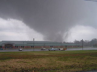
The tornado outbreak of November 15, 2005 was a tornado outbreak on November 15, 2005, in the Midwestern United States. It occurred along a cold front separating warm, humid air from the southeast from cold Arctic air to the north and northwest. 49 tornadoes were confirmed in the central United States in the states of Alabama, Arkansas, Illinois, Indiana, Kentucky, Missouri and Tennessee over that afternoon and evening. Strong winds and large hail caused additional damage throughout the region.
A red flag warning is a forecast warning issued by the National Weather Service in the United States to inform the public, firefighters, and land management agencies that conditions are ideal for wildland fire combustion, and rapid spread. After drought conditions, when humidity is very low, and especially when there are high or erratic winds which may include lightning as a factor, the Red Flag Warning becomes a critical statement for firefighting agencies. These agencies often alter their staffing and equipment resources dramatically to accommodate the forecast risk. To the public, a Red Flag Warning means high fire danger with increased probability of a quickly spreading vegetation fire in the area within 24 hours.
A flash flood warning is an alert issued issued by national weather forecasting agencies to warn the public that a flash flood is imminent or occurring in the warned area. A flash flood is a sudden, violent flood after a heavy rain, or occasionally after a dam break. Rainfall intensity and duration, topography, soil conditions, and ground cover contribute to flash flooding.
This article describes severe weather terminology used by the Meteorological Service of Canada, a branch within Environment and Climate Change Canada. The article primarily describes various weather warnings, and their criteria. Related weather scales and general weather terms are also addressed in this article. Some terms are specific to certain regions.
A tornado emergency is an enhanced version of a tornado warning, which is used by the National Weather Service (NWS) in the United States during imminent, significant tornado occurrences in highly populated areas. Although it is not a new warning type from the NWS, issued instead within a severe weather statement or in the initial tornado warning, a tornado emergency generally means that significant, widespread damage is expected to occur and a high likelihood of numerous fatalities is expected with a large, strong to violent tornado.
A significant weather advisory is issued when Doppler radar indicates a strong thunderstorm is producing small hail or high winds whose strength does not reach the criteria to be designated a severe thunderstorm. It does not necessarily account for lightning or flooding.
A flash flood watch is issued by the National Weather Service when conditions are favorable for flash flooding in flood-prone areas, usually when grounds are already saturated from recent rains, or when upcoming rains will have the potential to cause a flash flood. These watches are also occasionally issued when a dam may break in the near future.
Convective storm detection is the meteorological observation, and short-term prediction, of deep moist convection (DMC). DMC describes atmospheric conditions producing single or clusters of large vertical extension clouds ranging from cumulus congestus to cumulonimbus, the latter producing thunderstorms associated with lightning and thunder. Those two types of clouds can produce severe weather at the surface and aloft.
A weather warning generally refers to an alert issued by a meteorological agency to warn citizens of approaching dangerous weather. A weather watch, on the other hand, typically refers to an alert issued to indicate that conditions are favorable for the development of dangerous weather patterns, although the dangerous weather conditions themselves are not currently present.
A Wind Chill Watch is issued by the National Weather Service of the United States when the wind chill could reach dangerous levels within the next 12 to 48 hours. The exact definition required to issue a watch varies from state to state or from National Weather Service county warning areas to another, but if forecasters believe conditions are favorable for life-threatening wind chills meeting local criteria, a watch will be issued. People going outside should plan to protect themselves against hypothermia and frostbite.
A wind chill warning is issued by Environment Canada or the National Weather Service of the United States when the wind chill is low enough that it becomes life-threatening.
|title=
(help)