
The South West Coast Path is England's longest waymarked long-distance footpath and a National Trail. It stretches for 630 miles (1,014 km), running from Minehead in Somerset, along the coasts of Devon and Cornwall, to Poole Harbour in Dorset. Because it rises and falls with every river mouth, it is also one of the more challenging trails. The total height climbed has been calculated to be 114,931 ft (35,031 m), almost four times the height of Mount Everest. It has been voted 'Britain's Best Walking route' twice in a row by readers of The Ramblers' Walk magazine, and regularly features in lists of the world's best walks.

North Devon is a local government district in Devon, England. Its council is based just outside Barnstaple, the district's largest town. The district also includes the towns of Ilfracombe, Lynton and Lynmouth and South Molton along with numerous villages, seaside resorts and surrounding rural areas.
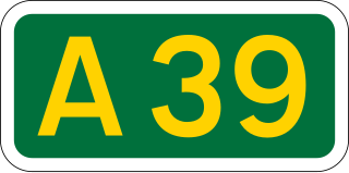
The A39 is an A road in south west England. It runs south-west from Bath in Somerset through Wells, Glastonbury, Street and Bridgwater. It then follows the north coast of Somerset, Devon and Cornwall through Williton, Minehead, Porlock, Lynmouth, Barnstaple, Bideford, Stratton, Camelford, Wadebridge and St Columb Major. It then joins the route of the A30 road for around 5 miles (8.0 km), re-emerging near Zelah to head for the south Cornish coast via Truro and Falmouth.

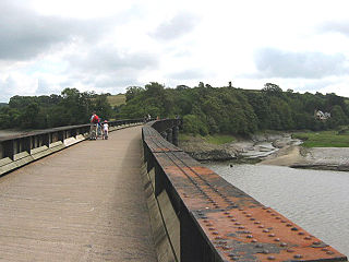
Instow is a village in north Devon, England. It is on the estuary where the rivers Taw and Torridge meet, between the villages of Westleigh and Yelland and on the opposite bank to Appledore. There is an electoral ward with the same name. The ward's total population at the 2011 census was 1,501.
The Tarka Line, also known as the North Devon Line, is a local railway line in Devon, England, linking the city of Exeter with the town of Barnstaple via a number of local villages, operated by Great Western Railway (GWR). The line opened in 1851 from Exeter to Crediton and in 1854 the line was completed through to Barnstaple. The line was taken over by the London and South Western Railway (LSWR) in 1865 and later became part of the Southern Railway and then British Rail. In 2001, following privatisation, Wessex Trains introduced the name Tarka Line after the eponymous character in Henry Williamson's book Tarka the Otter. The line was transferred to First Great Western in 2006.

The River Taw in England rises at Taw Head, a spring on the central northern flanks of Dartmoor, crosses North Devon and at the town of Barnstaple, formerly a significant port, empties into Bideford Bay in the Bristol Channel, having formed a large estuary of wide meanders which at its western end is the estuary of the River Torridge.
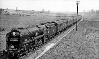
The Atlantic Coast Express (ACE) is an express passenger train in England that has operated at various times between London and seaside resorts in the South West England. It is currently operated as a summer only service by Great Western Railway between London Paddington and Newquay.
The Tarka Trail is a series of footpaths and cyclepaths around north Devon, England that follow the route taken by the fictional Tarka the Otter in the book of that name. It covers a total of 180 miles (290 km) in a figure-of-eight route, centred on Barnstaple.

Okehampton railway station is a terminus railway station on the Dartmoor line serving the town of Okehampton in Devon, England. The station closed to regular traffic in 1972, but heritage and occasional mainline services ran from 1997 to 2019. Regular railway services resumed in November 2021.

Yeoford railway station is a rural station serving the village of Yeoford in Devon, England. It is on the Tarka Line to Barnstaple, 11 miles 42 chains (18.5 km) from Exeter Central at milepost 183 from London Waterloo.
Barnstaple railway station is the northern terminus of the Tarka Line and serves the town of Barnstaple, Devon. It is 39 miles 75 chains (64.3 km) from Exeter Central and 211.25 miles (339.97 km) from London Waterloo. It is managed by Great Western Railway, which also operates the passenger service.
The North Devon Railway connected Barnstaple to the growing railway network in 1854 and as Ilfracombe developed as a watering place, it was obvious a railway connection to the town was needed. The hilly terrain was very difficult, but an Ilfracombe Railway was authorised in 1864 but failed when a major shareholder was unable to respond to a subscription call. After several false starts the Barnstaple and Ilfracombe Railway, soon taken over by the London and South Western Railway, opened in 1870.

The North Devon Railway was a railway company which operated a line from Cowley Bridge Junction, near Exeter, to Bideford in Devon, England, later becoming part of the London and South Western Railway's system. Originally planned as a broad gauge feeder to the Bristol & Exeter Railway, it became part of a battle between the broad gauge group and the standard gauge railway interests. In this context, standard gauge lines were often described as narrow gauge.

The Exeter to Plymouth railway of the London and South Western Railway (LSWR) was the westernmost part of a route competing with that of the Great Western Railway (GWR) and its 'associated companies' from London and Exeter to Plymouth in Devon, England. Whereas the GWR route from Exeter followed the coast to Newton Abbot and then went around the southern edge of Dartmoor, the LSWR route followed the northern and western margins of Dartmoor, passing through the towns of Crediton, Okehampton, and Tavistock.

Torrington railway station was a railway station located in Great Torrington, Devon. It was closed by British Railways in 1965 as part of the Beeching cuts.

Halwill Junction Railway Station was a railway station in Halwill Junction, near the villages of Halwill and Beaworthy in Devon, England. It opened in 1879 and formed an important junction between the now-closed Bude Branch and North Cornwall line. It closed in 1966 along with the lines which it served, a casualty of the Beeching Report.

Bideford Bay, also known as Barnstaple Bay and often shown on maps as Barnstaple or Bideford Bay, is a large area of water on the northwest coast of Devon in South West England, at the southwestern end of the Bristol Channel where it joins the Celtic Sea. The bay extends from Hartland Point in the southwest to Baggy point the northeast, and is partly sheltered by the island of Lundy, 12 miles (19 km) offshore. It takes its alternative names from the towns of Bideford and Barnstaple, located respectively on the rivers Torridge and Taw which flow into the bay. The alternative spelling Barnstable Bay, in use long after that spelling became obsolete for the town, is also sometimes seen.

The Granite Way is a route of 18 km consisting mainly of a motor traffic-free cycle/walkway between Okehampton and Lydford. It was built by Devon County Council (DCC) and is part of the National Cycle Network (NCN) Route 27 ‘Devon Coast to Coast’ between Ilfracombe and Plymouth. It is maintained jointly by DCC and Sustrans. Currently, the Way is supported by a Sunday-only train service during summer months to and from Okehampton railway station providing links to nearby Exeter run by DCC and Great Western Railway.

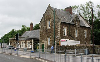
Instow railway station was a railway station in the village of Instow, North Devon, England, on the Bideford Extension of the North Devon Railway. Opened in November 1855, the station closed to passengers in 1965, but the line remained open for freight until 1982. The signal box has been preserved as a working attraction. The Atlantic Coast Express used to go through the station on its way to Torrington, but it did not call at Instow.

