Dhanora Motya

Last updated

Dhanora
Dhanora Motya
Village
CountryFlag of India.svg  India
State Maharashtra
District Parbhani
Government
  Type Grampanchayat
Elevation 384 m (1,260 ft)
Population (2011)
  Total 2,927
Languages
  Official Marathi
Time zone IST (UTC+5:30)
PIN 431511
Telephone code 02452
Vehicle registration MH-22

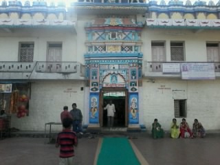
Dhanora, commonly known as "Dhanora Motya" is a village located in Purna taluka of Parbhani district, in the state of Maharashtra, India.

Purna Town in Maharashtra, India

Purna is a town with a municipal council in Parbhani district in the Indian state of Maharashtra.

Parbhani district District of Maharashtra in India

Parbhani district, is one of the eight districts in the Marathawada region of Maharashtra state of India. Parbhani city is the headquarters of this district. Parbhani district is well known for religious tourism of Jainism, Hinduism

Maharashtra State in western India

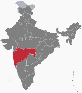
Maharashtra is a state in the western region of India. It is the second-most populous state and third-largest state by area in India. Spread over 307,713 km2 (118,809 sq mi), it is bordered by the Arabian Sea to the west, the Indian states of Karnataka and Goa to the south, Telangana and Chhattisgarh to the east, Gujarat and Dadra and Nagar Haveli to the north west, and Madhya Pradesh to the north. It is also the world's second-most populous subnational entity. It was formed by merging the western and south-western parts of the Bombay State, Berar and Vidarbha, and the north-western parts of the Hyderabad State and splitting Saurashtra by the States Reorganisation Act. It has over 112 million inhabitants and its capital, Mumbai, has a population around 18 million making it the most populous urban area in India. Nagpur hosts the winter session of the state legislature. Pune is known as 'Oxford of the East' due to the presence of several well-known educational institutions.

Contents

Demographics

As per 2011 census:

Location

Distance between Dhanora Motya, and district headquarter Parbhani is 48 kilometres (30 mi).

Related Research Articles

Pokharni village in Maharashtra, India

Pokharni is a village ,located in the Parbhani District of the Marathawada region of Maharashtra State of India. It is known for a temple dedicated to Narasimha.

Zari, Parbhani Village in Maharashtra, India

Zari is a major village in Parbhani taluka of Parbhani district of Maharashtra state in India.

Mirkhel Village/Railway station in Maharashtra, India

Mirkhel is a village and railway station in Parbhani taluka of Parbhani district in the Indian state of Maharashtra.

Pingali, Parbhani Village/Railway station in Maharashtra, India

Pingali also known as Pingali Kothala is a village and railway station in Parbhani taluka of Parbhani district in the Indian state of Maharashtra.

Pedgaon, Parbhani Village/Railway station in Maharashtra, India

Pedgaon is a major village and railway station in Parbhani district in Indian state of Maharashtra.

Asegaon, Jintur Village in Maharashtra, India

Asegaon is a village in Jintur taluka of Parbhani district of Indian state of Maharashtra. It is 27 km away from Parbhani city while it is 26 km away from Jintur. There is a Digambar Jain temple in the village.

Porwad, Parbhani Village in Maharashtra, India

Porwad is a village in Parbhani taluka of Parbhani district in Indian state of Maharashtra. It is located from 22 km away from district headquarter Parbhani on Parbhani-Gangakhed state highway 217.

Sayala, commonly known as "Sayala Khating" is a village located in Parbhani Taluka of Parbhani district, in state of Maharashtra.

Sayala is a village located in Palam Taluka of Parbhani district, in state of Maharashtra.

Shelgaon, commonly known as "Shelgaon Maratha", or "Shelgaon Mahavishnu" is a village located in Sonpeth taluka of Parbhani district, in state of Maharashtra.

Shelgaon, commonly known as "Shelgaon Hatkar" is a village located in Sonpeth taluka of Parbhani district, in state of Maharashtra.

Deulgaon, commonly known as "Deulgaon Dhudhate" is a village located in Purna taluka of Parbhani district, in state of Maharashtra.

Deulgaon, commonly known as Deulgaon Awachar, is a village located in Manwat taluka of Parbhani district, in the state of Maharashtra, India. It lies 18 kilometres (11 mi) from it taluka headquarters at Manwat.

Dharmapuri, Parbhani Village in Maharashtra, India

Dharmapuri is a village in Parbhani taluka of Parbhani district of Maharashtra state in India.

Nandkheda, Parbhani Village in Maharashtra, India

Nandkheda is a village in Parbhani taluka of Parbhani district of Maharashtra state in India.

Takli Bobade Village in Maharashtra, India

Takli Bobade is a village in Parbhani taluka of Parbhani district of Maharashtra state in India.

Jamb, Parbhani Village in Maharashtra, India

Jamb also known as Jam is a village in Parbhani taluka of Parbhani district of Maharashtra state in India.

Bramhangaon, Parbhani Village in Maharashtra, India

Bramhangaon also known as Bramangaon is a village in Parbhani taluka of Parbhani district of Maharashtra state in India.

Wangi, Parbhani Village in Maharashtra, India

Wangi is a village in Parbhani taluka of Parbhani district of Maharashtra state in India.

Palam taluka is one of the nine talukas in Parbhani district. Palam is the headquarter of Palam taluka.

References

    Coordinates: 19°05′N77°08′E / 19.083°N 77.133°E / 19.083; 77.133

    Geographic coordinate system Coordinate system

    A geographic coordinate system is a coordinate system that enables every location on Earth to be specified by a set of numbers, letters or symbols. The coordinates are often chosen such that one of the numbers represents a vertical position and two or three of the numbers represent a horizontal position; alternatively, a geographic position may be expressed in a combined three-dimensional Cartesian vector. A common choice of coordinates is latitude, longitude and elevation. To specify a location on a plane requires a map projection.