Camden is a city in and the county seat of Ouachita County in the south-central part of the U.S. state of Arkansas. The city is located about 100 miles south of Little Rock. Situated on the bluffs overlooking the Ouachita River, Camden is a city rich in history, most of which is tied to the river. The recorded history began in 1782 when a Spanish military post was established on the site of an old French trading post called Ecore à Fabri. When Ouachita County was formed in 1842, American settlers changed the name to Camden. The city became an important port during the steamboat era when Camden became known as the “Queen City” of the Ouachita. In 1864, Camden became the unintended focus of the Red River Campaign, a major Civil War effort resulting in several significant battles.

Historic Washington State Park is a 101-acre (41 ha) Arkansas state park in Hemsptead County, Arkansas in the United States. The museum village contains a collection of pioneer artifacts from the town of Washington, Arkansas, which is a former pioneer settlement along the Southwest Trail. Walking interpretive tours are available throughout the 54 buildings. Washington served as a major trading point along the Southwest Trail, evolving into the Hempstead county seat and later the capital of Arkansas from 1863 to 1865 when Little Rock was threatened during the Civil War. The original plat of Washington was added to the National Register of Historic Places in 1972 as the Washington Historic District.

The Battle of Mansfield, also known as the Battle of Sabine Crossroads, on April 8, 1864 in Louisiana formed part of the Red River Campaign during the American Civil War, when Union forces were attempting to occupy the Louisiana state capital, Shreveport.
Spring Hill may refer to:

The National Register of Historic Places in the United States is a register including buildings, sites, structures, districts, and objects. The Register automatically includes all National Historic Landmarks as well as all historic areas administered by the U.S. National Park Service. Since its introduction in 1966, more than 90,000 separate listings have been added to the register.

The Camden Expedition was the final campaign conducted by the United States Army against the Confederate States Army in Arkansas, during the American Civil War. The offensive was designed to cooperate with Maj. Gen. Banks' movement against Shreveport.

Walker's Greyhounds was the popular name for a division of the Confederate States Army under Major-General John George Walker, composed exclusively of units from Texas. It fought in the Western Theater and the Trans-Mississippi Department, gaining its nickname because the men were able to move long distances rapidly on foot.

The Camden Expedition Sites is a national historic landmark consisting of nine nationally significant historic places in southwest Arkansas where events of the Union army's disastrous Camden Expedition of 1864 occurred during the American Civil War. The Union was attempting to take over Shreveport, Louisiana. Each of the sites are individually listed on the National Register of Historic Places. It was designated a national historic landmark on April 19, 1994.
Fort Southerland, also known as Redoubt E, is a defensive fortification erected during the American Civil War on what was then the outskirts of Camden, Arkansas. The oval earthworks are now the centerpiece of a city park off Bradley Ferry Road on the east side of the city. It was listed on the National Register of Historic Places in 1994, and, with other sites, is part of the Camden Expedition Sites National Historic Landmark.

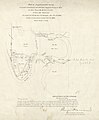
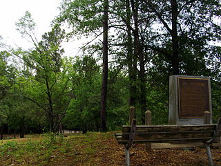
The Prairie D'Âne Battlefield, also known as Prairie D'Ann Battlefield or Prairie De Ann Battlefield in anglicized forms, was the site of the Civil War Battle of Prairie d'Âne, one of the engagements in southwestern Arkansas of the Union's Camden Expedition of 1864. It was listed on the National Register of Historic Places in 1974, and, with other sites, is part of the Camden Expedition Sites National Historic Landmark. It was declared part of the National Historic Landmark in 1994.

The Port Hudson State Historic Site is located on the Mississippi River north of Baton Rouge in East Feliciana Parish, Louisiana, just outside the limits of Port Hudson and in the vicinity of Jackson. The site preserves a portion of the fortifications and battle area of the longest siege in American history, during the American Civil War from May 23 through July 9, 1863. The state of Louisiana maintains the site, which includes a museum about the siege, artillery displays, redoubts, and interpretive plaques. Living history re-enactments are held each year. It was designated a National Historic Landmark in 1974, significant as the first place where African-American military units fought for the Union Army under African-American field leadership.

Liendo Plantation is an historic cotton plantation in Waller County, Texas, United States. Named after its original owner, José Justo Liendo, the plantation was purchased in 1873 by sculptor Elisabet Ney and her husband, physician Edmund Montgomery. The plantation is a Recorded Texas Historic Landmark and is listed on the National Register of Historic Places.

The following outline is provided as an overview of and topical guide to the U.S. state of Arkansas:

Fort DeRussy, located south of Alexandria, Louisiana, and four miles (6 km) north of Marksville, was a Confederate earthwork stronghold during the American Civil War. It was built in 1862 to defend the lower Red River Valley in Louisiana. Located in Avoyelles Parish, the fort, cemetery and water batteries were designated as a state historic site in 1994. The fort and the water battery were listed on the National Register of Historic Places in 2016.

This is a list of the National Register of Historic Places listings in Hempstead County, Arkansas.
The 34th Arkansas Infantry was an infantry regiment of the Confederate States Army during the American Civil War. The regiment was originally designated by the state military board as the 2nd Regiment, Northwest Division, District of Arkansas. The unit spent its entire existence in the Department of the Trans-Mississippi.
The 12th Arkansas Infantry (1861–1865) was a Confederate Army infantry regiment during the American Civil War. The regiment spent much of its service defending Confederate strong points along the Mississippi River. The unit participated in the defense of Island No. 10 in early 1862 and later became part of the garrison of Port Hudson in 1863. Following the capitulation of the garrison of Port Hudson, the survivors of the 12th were eventually paroled and exchanged back to Arkansas where the regiment was consolidated with the remnants of several other Arkansas regiments to become the 2nd Arkansas Consolidated Infantry Regiment.

The 22nd Arkansas Infantry Regiment was a Confederate Army infantry regiment during the American Civil War (1862–1865). This regiment was originally organized as the 17th Arkansas Infantry Regiment, reorganized after the battle of Pea Ridge as 1st Regiment, Northwest Division, Trans-Mississippi Department, or Rector's War Regiment, redesignated as the 35th Arkansas in the summer of 1862, and reorganized and redesignated as the 22nd Arkansas following the Battle of Prairie Grove. The unit was also sometimes referred to as, King's Arkansas Infantry or McCord's Arkansas Infantry. This was the second regiment to be officially designated as the 22nd Arkansas. The first was mustered in at DeValls Bluff, Arkansas, on April 9, 1862, and later reorganized as the 20th Arkansas Infantry Regiment.

The 37th Arkansas Infantry Regiment (1862–1865) was a Confederate Army infantry regiment during the American Civil War. It was originally designated as the 29th Arkansas Infantry Regiment and was also known as 1st Trans-Mississippi Infantry Regiment. The unit served in the Department of the Trans-Mississippi from its formation in the summer of 1862 until the surrender in May 1865.
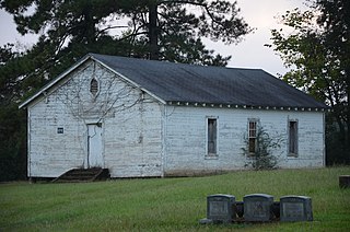
Moscow Methodist Church and Cemetery is a historic landmark that was built in 1864 and added to the National Register in 2006. The former community of Moscow is located just outside the current city limits of Prescott, Arkansas. The area is on or near the old "Moscow-Camden Road", or "Wire Road" which ran between Moscow and Camden, Arkansas. As of 2016, the location was known as the junction of Nevada County Roads 23 and 260.