Downtown East St. Louis Historic District

Last updated
Downtown East St. Louis Historic District
20030720 22 East St. Louis, IL (6116695806).jpg
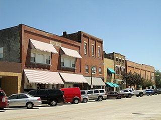
Collinsville Avenue in 2003
USA Illinois location map.svg
Red pog.svg
Usa edcp location map.svg
Red pog.svg
LocationPortions of Collinsville, Missouri, and St. Louis Aves., East St. Louis, Illinois
Coordinates 38°37′38″N90°9′32″W / 38.62722°N 90.15889°W / 38.62722; -90.15889 Coordinates: 38°37′38″N90°9′32″W / 38.62722°N 90.15889°W / 38.62722; -90.15889
NRHP reference # 14000622 [1]
Added to NRHPSeptember 17, 2014

The Downtown East St. Louis Historic District is a historic commercial district in downtown East St. Louis, Illinois. The district includes 35 buildings, 25 of which are contributing buildings, along Collinsville Avenue, Missouri Avenue, and St. Louis Avenue; all but one of the buildings was historically used for commercial purposes. While development in the area dates back to the late 19th century, the first of the extant buildings in the district were built around 1900 after a tornado devastated the area in 1896. By 1910, the area had become a prosperous commercial district with stores, offices, and entertainment venues; surviving buildings from this period include the Murphy Building and the Cahokia Building. Another large building boom took place in the 1920s, adding buildings such as the Spivey Building, the city's only skyscraper; the Union Trust Bank Company Building, the largest bank in the city; the Grossman Building; and the Majestic Theatre. The new buildings both coincided with a population and economic expansion in the city and allowed it to forge an architectural identity distinct from neighboring St. Louis. [2]

East St. Louis, Illinois City in Illinois, United States

East St. Louis is a city in St. Clair County, Illinois, United States within Greater St. Louis. It is located directly across the Mississippi River from Downtown St. Louis and the Gateway Arch National Park. East St. Louis is in what is defined as the Metro-East region of Southern Illinois. Once a bustling industrial center, like many cities in the Rust Belt, East St. Louis has been severely affected by loss of jobs due to industrial restructuring during the second half of the 20th century. In 1950, East St. Louis was the fourth-largest city in Illinois when its population peaked at 82,366. As of the 2010 census, the city had a population of 27,006, less than one-third of the 1950 census.

Illinois American State

Illinois is a state in the Midwestern and Great Lakes regions of the United States. It has the fifth largest gross domestic product (GDP), the sixth largest population, and the 25th largest land area of all U.S. states. Illinois has been noted as a microcosm of the entire United States. With Chicago in northeastern Illinois, small industrial cities and immense agricultural productivity in the north and center of the state, and natural resources such as coal, timber, and petroleum in the south, Illinois has a diverse economic base, and is a major transportation hub. Chicagoland, Chicago's metropolitan area, encompasses over 65% of the state's population. The Port of Chicago connects the state to international ports via two main routes: from the Great Lakes, via the Saint Lawrence Seaway, to the Atlantic Ocean and from the Great Lakes to the Mississippi River, via the Illinois Waterway to the Illinois River. The Mississippi River, the Ohio River, and the Wabash River form parts of the boundaries of Illinois. For decades, Chicago's O'Hare International Airport has been ranked as one of the world's busiest airports. Illinois has long had a reputation as a bellwether both in social and cultural terms and, through the 1980s, in politics.

Spivey Building United States historic place

The Spivey Building is a twelve-story skyscraper located at 417 Missouri Avenue in East St. Louis, Illinois. Built in 1927, the building is the only skyscraper ever constructed in East St. Louis. Architect Albert B. Frankel designed the building in the Commercial style. The building's design features terra cotta spandrels separating its windows vertically and brick pier dividing its window bays. The asymmetrical entrance is surrounded by decorative marble piers, and the first two stories are separated from the rest of the building by a cornice and sill. The top of the building features a two-story parapet with terra cotta surrounds at each window and seven capitals at its peak. During the height of East St. Louis' prosperity through the 1950s, the building housed the offices of professionals in many fields who were considered among the best in the city. However, the building became a victim of the city's steep economic decline and has been abandoned for several decades.

Beginning in the 1960s, East St. Louis and its downtown entered a period of dramatic decline. Several major businesses left the city for other suburbs, urban decay and blight struck the city, resulting in the abandonment or demolition of several major commercial buildings. In addition, the rise of the automobile and the construction of new expressways took foot traffic away from the downtown area, furthering the decline of its businesses. The city's population is now one-third of its peak in 1950, and many of the district's buildings are abandoned and at risk of demolition or major decay. [2]

Urban decay Sociological process affecting cities

Urban decay is the sociological process by which a previously functioning city, or part of a city, falls into disrepair and decrepitude. It may feature deindustrialization, depopulation or deurbanization, economic restructuring, abandoned buildings and infrastructure, high local unemployment, increased poverty, fragmented families, low overall living standards and quality of life, political disenfranchisement, crime, elevated levels of pollution, and a desolate cityscape, known as greyfield or urban prairie. Since the 1970s and 1980s, urban decay has been associated with Western cities, especially in North America and parts of Europe. Since then, major structural changes in global economies, transportation, and government policy created the economic and then the social conditions resulting in urban decay.

The district was added to the National Register of Historic Places on September 17, 2014. [1]

National Register of Historic Places Federal list of historic sites in the United States

The National Register of Historic Places (NRHP) is the United States federal government's official list of districts, sites, buildings, structures and objects deemed worthy of preservation for their historical significance. A property listed in the National Register, or located within a National Register Historic District, may qualify for tax incentives derived from the total value of expenses incurred in preserving the property.

Related Research Articles

Gaslamp Quarter, San Diego United States historic place

The Gaslamp Quarter is a district of San Diego, California. It is a 16½ block historical neighborhood in Downtown San Diego, and is the site of several entertainment and night life venues, as well as scheduled events and festivals, including Mardi Gras in the Gaslamp, Street Scene Music Festival, Taste of Gaslamp and ShamROCK, a St. Patrick's Day event. Petco Park, home of the San Diego Padres is located one block away in downtown San Diego's East Village.

Downtown Duluth United States historic place

The Downtown of Duluth, Minnesota, United States, is situated between Mesaba Avenue and 4th Avenue East; and located on Michigan, Superior, First, Second, and Third Streets.

Washington Avenue Historic District (St. Louis, Missouri) United States historic place

The Washington Avenue Historic District is located in Downtown West, St. Louis, Missouri along Washington Avenue, and bounded by Delmar Boulevard to the north, Locust Street to the south, 8th Street on the east, and 18th Street on the west. The buildings date from the late 19th century to the early 1920s and exhibit a variety of popular architectural styles of those eras. The majority of the district's buildings are revival styles or in the commercial style that would later come to be known as the Chicago School of architecture. Most buildings originally served as warehouses for the St. Louis garment district and are large multi-story buildings of brick and stone construction. Many have terra cotta accents on their facades. After World War II, the decline in domestic garment production and the preference for single-story industrial space led to many of the buildings being vacant or underused due to functional obsolescence.

Downtown St. Louis Neighborhood of St. Louis in Missouri, United States

Downtown St. Louis is the central business district of St. Louis, Missouri, the hub of tourism and entertainment, and the anchor of the St. Louis metropolitan area. The downtown is bounded by Cole Street to the north, the river front to the east, Chouteau Avenue to the south, and Tucker Boulevard to the west. The downtown is the site of many corporate headquarters, including Stifel Financial Corp., HOK, Spire Inc., and a host of other companies.

Downtown (Washington, D.C.) United States historic place

Downtown is a neighborhood of Washington, D.C., as well as a colloquial name for the central business district in the northwest quadrant of the city. Geographically, the area extends roughly five to six blocks west, northwest, north, northeast, and east of the White House. Several important museums, theaters, and a major sports venue are located in the area. A portion of this area is known as the Downtown Historic District and was listed on the NRHP in 2001.

Fountain Square, Indianapolis Indianapolis Cultural District in the United States

Fountain Square is one of seven designated cultural districts in Indianapolis, Indiana. Located at Fountain Square are three designated national historic districts: the Laurel and Prospect District, State and Prospect District, and Virginia Avenue District. They were listed on the National Register of Historic Places in 1983.

Downtown Grand Forks United States historic place

Downtown Grand Forks is the original commercial center of Grand Forks, North Dakota. Located on the western bank of the Red River of the North, the downtown neighborhood is situated near the fork of the Red River and the Red Lake River. While downtown is no longer the dominant commercial area of the Greater Grand Forks community, it remains the historic center of Grand Forks. An 80.4-acre (32.5 ha) portion was listed on the National Register of Historic Places in 2005, as Downtown Grand Forks Historic District. Today, downtown Grand Forks is home to many offices, stores, restaurants, and bars.

Downtown Norfolk, Virginia Central Business District

Downtown Norfolk serves as the traditional center of commerce, government, and culture in the Hampton Roads region. Norfolk, Virginia's downtown waterfront shipping and port activities historically played host to numerous and often noxious port and shipping-related uses. With the advent of containerized shipping in the mid-19th century, the shipping uses located on Norfolk's downtown waterfront became obsolete as larger and more modern port facilities opened elsewhere in the region. The vacant piers and cargo warehouses eventually became a blight on downtown and Norfolk's fortunes as a whole. But in the second half of the century, Norfolk had a vibrant retail community in its suburbs; companies like Smith & Welton, High's, Colonial Stores, Goldman's Shoes, Lerner Shops, Hofheimer's, Giant Open Air, Dollar Tree and K & K Toys were regional leaders in their respective fields. Norfolk was also the birthplace of Econo-Travel, now Econo Lodge, one of the nation's first discount motel chains.

Peoples State Bank (Orangeville, Illinois) United States historic place

The People's State Bank building is located in the Stephenson County village of Orangeville, Illinois, United States. The structure was erected in 1926 when two Orangeville banks merged to form the People's State Bank. It operated until 1932 when it became overwhelmed by an economic disaster caused by the Great Depression and the bypassing of downtown Orangeville by an important route. The building is cast in the Commercial style and features Classical Revival detailing, common for banks of the time period. The building was added to the U.S. National Register of Historic Places in 2004.

Broadway Avenue Historic District (Detroit, Michigan) United States historic place

The Broadway Avenue Historic District is a historic district located on a single city block along Broadway Avenue between Gratiot and East Grand River in downtown Detroit, Michigan. It was listed on the National Register of Historic Places in 2004. The Broadway Avenue Historic District joins the Randolph Street Commercial Buildings Historic District, a rare surviving commercial area which dates from the 1840s.

Downtown Albany Historic District United States historic place

The Downtown Albany Historic District is a 19-block, 66-acre (27 ha) area of Albany, New York, United States, centered on the junction of State and North and South Pearl streets. It is the oldest settled area of the city, originally planned and settled in the 17th century, and the nucleus of its later development and expansion. In 1980 it was designated a historic district by the city and then listed on the National Register of Historic Places.

Historic districts in Meridian, Mississippi

There are nine historic districts in Meridian, Mississippi. Each of these districts is listed on the National Register of Historic Places. One district, Meridian Downtown Historic District, is a combination of two older districts, Meridian Urban Center Historic District and Union Station Historic District. Many architectural styles are present in the districts, most from the late 19th century and early 20th century, including Queen Anne, Colonial Revival, Italianate, Art Deco, Late Victorian, and Bungalow.

Crescent Warehouse Historic District United States historic place

The Crescent Warehouse Historic District is a 10.5-acre (4.2 ha) historic district in Downtown Davenport, Iowa, United States. The district is a collection of multi-story brick structures that formerly housed warehouses and factories. Most of the buildings have been converted into loft apartments. The district was listed on the National Register of Historic Places in 2003.

Greenwich Avenue Historic District United States historic place

The Greenwich Avenue Historic District is a historic district representing the commercial and civic historical development of the downtown area of the town of Greenwich, Connecticut. The district was listed on the National Register of Historic Places on August 31, 1989. Included in the district is the Greenwich Municipal Center Historic District, which was listed on the National Register the year before for the classical revival style municipal buildings in the core of Downtown. Most of the commercial buildings in the district fall into three broad styles, reflecting the period in which they were built: Italianate, Georgian Revival, and Commercial style. The district is linear and runs north-south along the entire length of Greenwich Avenue, the main thoroughfare of Downtown Greenwich, between U.S. Route 1 and the New Haven Line railroad tracks.

Downtown Peotone Historic District United States historic place

The Downtown Peotone Historic District is a set of forty-two buildings in Peotone, Illinois. Of these, thirty-seven contribute to the historical integrity of the area.

Moline Downtown Commercial Historic District United States historic place

The Moline Downtown Commercial Historic District is a nationally recognized historic district located in Moline, Illinois, United States. Centered on 5th Avenue, it is roughly bounded by 12th Street to 18th Street, 4th Avenue to 7th Avenue. The distinct covers 33-acre (0.13 km2) and includes 114 buildings. One hundred of the buildings contribute to the significance of the district because they retain their historic and architectural integrity and reflect the character of the historic downtown.

This is a list of properties and historic districts within the Downtown St. Louis and Downtown West, St. Louis areas of the city of St. Louis, Missouri that are listed on the National Register of Historic Places. The downtown area is defined by Cole Street to the north, the river front to the east, Chouteau Avenue to the south, and Jefferson Avenue to the west. Tucker Avenue divides Downtown to the east from Downtown West to the west.

Helena Historic District (Helena, Montana) United States historic place

The Helena Historic District (HHD) is a federally designated historic district in Helena, Montana, United States. Since its establishment in 1972, the HHD has had boundary adjustments in 1990 and 1993. The original 1972 designation was composed of two unconnected sections known as "Downtown" and "West Residential".

Union Trust Bank Company Building United States historic place

The Union Trust Bank Company Building is a historic bank building located at 200 Collinsville Avenue in downtown East St. Louis, Illinois. Built from 1922 to 1926, the building housed the Union Trust & Savings Bank, which was founded in 1901 by August Schlafly. Architect Thomas Imbs designed the Classical Revival building. The bank's opening followed a major race riot and a series of corruption scandals in East St. Louis, and its construction marked a turnaround in what had until then been a struggling city. The new building inspired confidence in the city's downtown, and several landmark buildings were built in downtown East St. Louis in the ensuing decade. The building was one of two Classical Revival banks built in East St. Louis and is the only one which is still standing.

Lansing Downtown Historic District United States historic place

The Lansing Downtown Historic District is a primarily commercial and office historic district located in downtown Lansing, Michigan. The district stretches along the east side of Capitol Avenue from Ionia Street to Lenawee Street, and along both sides of Grand Avenue between Michigan and Washtenaw, with additional structures along Kalamazoo Street between Walnut and Grand and along Lenawee Street between Washington and Walnut. The district was listed on the National Register of Historic Places in 2009.

References

  1. 1 2 "Weekly List of Actions Taken on Properties: 9/15/14 Through 9/19/14". National Park Service. September 26, 2014. Retrieved October 11, 2015.
  2. 1 2 Allen, Michael R.; Slocum, Lydia (March 28, 2014). "National Register of Historic Places Registration Form: Downtown East St. Louis Historic District" (PDF). Illinois Historic Preservation Agency. Archived from the original (PDF) on March 4, 2016. Retrieved October 11, 2015.