Dukart's Canal

Last updated

Dukart's Canal
Specifications
Locks3 inclined planes
Statusdefunct
History
Principal engineer Davis Dukart
Date of act1767
Date completed1777
Date closed1787
Geography
Start pointDrumglass
End point Coalisland
Connects to Coalisland Canal

Dukart's Canal was built to provide transport for coal from the Drumglass Collieries to the Coalisland Canal in County Tyrone, Ulster, Ireland. It opened in 1777, and used three inclined planes, rather than locks, to cope with changes in level. There is little evidence that it was ever used, as the planes could not be made to work properly, and they were dismantled in 1787.

Contents

History

Coal seams were discovered at Drumglass, near Coalisland, in the 1690s, and the Tyrone coalfields were seen as a way to reduce the amount of coal imported to Dublin, then amounting to between 60,000 and 70,000 tons per year. Thomas Knox, an owner of one of the collieries, petitioned the Irish Parliament in 1709, to advocate the cutting of a canal to enable the resource to be transported more easily. The canal would have followed a similar route to the later Newry Canal, but nothing came of the plan, although it was well received. The scheme was revived in 1727, and assessed by the Surveyor-General in 1729. Also in 1729, Francis Seymour, the owner of a coal pit at Brackaville, near Coalisland, published a pamphlet in Belfast, titled Remarks on a Scheme for supplying Dublin with Coals. The pamphlet expressed support for Knox's plans of 1709, but also suggested that a canal could be cut from Drumglass to the River Torrent, which would enable small boats to reach the River Blackwater, where the coal could be loaded into larger boats for transport to Newry, and onwards to Dublin. [1]

The Commission of Inland Navigation for Ireland was created in the same year, and authorised the construction of the Newry Canal in 1731. A canal from Coalisland to the Blackwater was authorised the following year, but had the serious disadvantage that it stopped well short of the coalfields. Its construction was extremely slow, and the overland transport of coal to Coalisland increased its cost to customers. To address this situation, a company was created in 1749, prominent members of which included the Church of Ireland Lord Archbishop of Armagh and the Church of Ireland Lord Archbishop of Tuam. They asked Parliament in 1753 for help with building 3 miles (4.8 km) of road, to link Drumglass to Coalisland, and received £4,000 to carry out the work. [2]

It is unclear whether the road was ever completed. In 1760 a Parliamentary Committee asked Thomas Omer to carry out a survey for a canal between the collieries and the Newry Navigation. Although he carried out the survey, he suggested that a more practical solution would be to build a canal to Coalisland Basin. This would need to be just over 3 miles (4.8 km) long, would require 16 locks, and would cost £15,667. The bed of the River Torrent would be used where possible, and Omer began work in 1761. The Committee wanted the canal to be capable of carrying 100-ton ships. Omar passed the supervision of the project on to a British architectural engineer called Christopher Myers in June 1762, who completed around 0.5 miles (0.80 km) of the canal near Coalisland, and built part of the first lock. The waterway was 10 feet (3.0 m) deep, and the lock was 125 by 22 feet (38.1 by 6.7 m). He then reported to Parliament, outlining the likely cost based on the progress to that point, and concluded that it was impracticable to use the bed of the river. He suggested that a canal of the same gauge as the Newry Canal, capable of taking boats 60 by 12 feet (18.3 by 3.7 m) and drawing 3 feet (0.91 m), was a more realistic solution, and could be achieved for £18,141, which included the construction of 14 locks and an aqueduct over the River Torrent. [3]

Dukart's Design

Dukart's Canal
BSicon ugWHRF.svg
Drumglass Colliery wharf
BSicon gSTR.svg
BSicon ugPLANEu.svg
Farlough Dry Hurry
BSicon gSTR.svg
BSicon uexSTR+l.svg
BSicon geuKRZo.svg
BSicon uexSTRq.svg
River Torrent aqueduct
BSicon uexSTR.svg
BSicon gSTR.svg
BSicon uexSTR.svg
BSicon ugPLANEu.svg
Drumreagh Dry Hurry
BSicon uexSTR.svg
BSicon gSTR.svg
BSicon uexSTR.svg
BSicon ugPLANEu.svg
Brackaville Dry Hurry
BSicon uexSTR.svg
BSicon gSTR.svg
BSicon uexSTR.svg
BSicon uexBHF.svg
Coalisland basin
BSicon uexCONTf.svg
BSicon uexCONTf.svg
R Torrent and Coalisland Canal

Although the proposal made by Myers was adopted by Parliament in 1767, and £5,000 granted towards its cost, it was superseded by a plan submitted by Daviso Du Arcort, a Sardinian, otherwise known as Davis Dukart, after a second opinion on the engineering aspects of the project was sought. Dukart's plan was probably influenced by the Bridgewater Canal, which had reached Manchester in 1765. James Brindley, the engineer for that scheme, had used tub boats, capable of carrying 12 tons, and at the Castlefield terminus in Manchester, had constructed a vertical shaft, so that boxes of coal could be raised from the boats to a higher level. Dukart also planned to use 12-ton tub boats. The canal would be built on two levels, the first starting from Coalisland, and running into a tunnel, which would be used to provide drainage for Derry Colliery. A shaft would rise for 148 feet (45 m) above the end of the tunnel, and coal would be lowered down it in boxes, either from the colliery workings, or from boats arriving at the top of the shaft on the upper level. The upper level would cross the River Torrent on a 3-arched aqueduct, and would again end in a tunnel. [4]

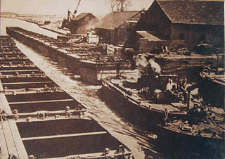
The new plan was approved by Parliament, and by November 1767 he had built two small sections and some of the aqueduct. The work had cost £3,839, and he estimated that another £14,457 would be needed to complete the scheme. Three months later, the cost was revised to £26,802, and again the plans were changed. The tunnel sections were replaced by three gravitational inclines originally designed with wooden ramps and rollers. These were located at Brackaville with a rise of 16.8 m (55 ft), at Drumreagh with a rise of 19.8 m (65 ft) and at Farlough with a rise of 21.3 m (70 ft), and were referred to a 'hurries' or 'dry wherries'. The canal sections were completed by mid-1773, but Dukart experienced problems with provision of power to make the inclines work. William Jessop was sent to inspect the works by John Smeaton, both of whom were involved in surveying a route for the proposed Grand Canal from Dublin to the River Shannon. Jessop's report has been lost, but Smeaton recommended converting the inclines to be counterbalanced, increasing the size of the boats from one ton to two, and suggested a winch at the top of the incline to haul the boats over the sill at the end of the level and on to the start of the incline. He also mentioned that he thought a horse railroad would have been better than a canal, in view of the terrain. [5]

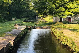
Dukart could still not get the inclines to work well, and replaced the rollers with parallel railway tracks, down which the boats were carried on cradles. At the Coalisland basin, the tub boats descended the final 15 feet (4.6 m) on another cradle, which turned them over, to tip their contents into canal boats. The work was finally finished in 1777, and at least one boat travelled along the length of the canal, but the through route to the River Blackwater, along the Coalisland Canal, would not be completed for another ten years. Problems with the new route soon became apparent. The upper section was cut through limestone, and Farlough Lake, one of the canal's water sources, could not supply sufficient volumes of water to overcome seepage. Additionally, the inclines had been made too steep for the counterbalance mechanism to work well. In 1787, when an engineer called Richard Owen was sent by the Corporation for Inland Navigation to inspect the route, he found the hurries suffering from mechanical failure and little water in the upper section. He suggested the replacement of the tub boats by flat-bottomed barges on each level, 40 by 13 feet (12.2 by 4.0 m), each of which would carry two rows of seven wagons. At the inclines, the wagons would be run of the boats, and down inclined roads which would replace the inclines, to be loaded onto another boat at the bottom. Echoing Dukart's first design, he also suggested a new canal, some 3.7 miles (6.0 km) long, running from below Coalisland basin to Drumglass. The final 2.5 miles (4.0 km) or so would be in tunnel, which would also act as a drain for the collieries. His plan did not meet with any official approval. [6]

Dukart's legacy

The canal was the only place where inclines were used within Ireland's waterways. Legend has it that only one tub boat ever came down Dukart's Canal, in 1778. This exercise was completed to help save him from the accusation of serious misuse of public funds, but the inclines were a failure and were dismantled by 1787. Dukart died in 1785. [7]

Very little remains of the canal. Some masonry and a bridge over an incline still exist. [7] Dukart's name is still linked with Newmills and the Coalisland Canal. The most prominent canal structure still extant is the ashlar stone aqueduct at Newmills, built around 1768, where the canal was carried over the River Torrent. [8] The remains of two of the inclines (known locally as Dry Hurries) are still visible. One can be found in Drumreagh near the Brackaville Golf Course. The largest is on the Quintinmanus Road near Newmills (although this one is largely overgrown and is hard to see). The town of Newmills was built around Dukart's failed canal.

Dukart was in many ways way ahead of his time. Inclined planes are frequently used today in different parts of the world in many different guises. It was a very ambitious gamble that unfortunately for Davis Dukart did not pay off. [7]

See also

Bibliography

Related Research Articles

Aire and Calder Navigation Canal in West Yorkshire, England

The Aire and Calder Navigation is the canalised section of the Rivers Aire and Calder in West Yorkshire, England. The first improvements to the rivers above Knottingley were completed in 1704 when the Aire was made navigable to Leeds and the Calder to Wakefield, by the construction of 16 locks. Lock sizes were increased several times, as was the depth of water, to enable larger boats to use the system. The Aire below Haddlesey was bypassed by the opening of the Selby Canal in 1778. A canal from Knottingley to the new docks and new town at Goole provided a much shorter route to the River Ouse from 1826. The New Junction Canal was constructed in 1905, to link the system to the River Don Navigation, by then part of the Sheffield and South Yorkshire Navigation.

Manchester Bolton & Bury Canal Canal in Manchester, UK

The Manchester Bolton & Bury Canal is a disused canal in Greater Manchester, England, built to link Bolton and Bury with Manchester. The canal, when fully opened, was 15 miles 1 furlong (24.3 km) long. It was accessed via a junction with the River Irwell in Salford. Seventeen locks were required to climb to the summit as it passed through Pendleton, heading northwest to Prestolee before it split northwest to Bolton and northeast to Bury. Between Bolton and Bury the canal was level and required no locks. Six aqueducts were built to allow the canal to cross the rivers Irwell and Tonge and several minor roads.

Morris Canal Canal in New Jersey

The Morris Canal (1829–1924) was a 107-mile (172 km) common carrier coal canal across northern New Jersey in the United States that connected the two industrial canals at Easton, Pennsylvania, across the Delaware River from its western terminus at Phillipsburg, New Jersey, to New York Harbor and the New York City markets via its eastern terminals in Newark and on the Hudson River in Jersey City, New Jersey.

Canal inclined plane

An inclined plane is a type of cable railway used on some canals for raising boats between different water levels. Boats may be conveyed afloat, in caissons, or may be carried in cradles or slings.

Chard Canal

The Chard Canal was a 13.5 miles (21.7 km) tub boat canal in Somerset, England, that ran from the Bridgwater and Taunton Canal at Creech St. Michael, over four aqueducts, through three tunnels and four inclined planes to Chard. It was completed in 1842, was never commercially viable, and closed in 1868. The major engineering features are still clearly visible in the landscape.

Leominster Canal Canal in England, now defunct

The Leominster Canal was an English canal which ran for just over 18 miles from Mamble to Leominster through 16 locks and a number of tunnels, some of which suffered engineering problems even before the canal opened. Originally the canal was part of a much more ambitious plan to run 46 miles from Stourport to Kington.

Shrewsbury Canal

The Shrewsbury Canal was a canal in Shropshire, England. Authorised in 1793, the main line from Trench to Shrewsbury was fully open by 1797, but it remained isolated from the rest of the canal network until 1835, when the Birmingham and Liverpool Junction Canal built the Newport Branch from Norbury Junction to a new junction with the Shrewsbury Canal at Wappenshall. After ownership passed to a series of railway companies, the canal was officially abandoned in 1944; many sections have disappeared, though some bridges and other structures can still be found. There is an active campaign to preserve the remnants of the canal and to restore the Norbury to Shrewsbury line to navigation.

Newry Canal Canal in Northern Ireland, United Kingdom.

The Newry Canal, located in Northern Ireland, was built to link the Tyrone coalfields to the Irish Sea at Carlingford Lough near Newry. It was the first summit level canal to be built in Ireland or Great Britain, and pre-dated the more famous Bridgewater Canal by nearly thirty years and Sankey Canal by fifteen years. It was authorised by the Commissioners of Inland Navigation for Ireland, and was publicly funded. It was opened in 1742, but there were issues with the lock construction, the width of the summit level and the water supply. Below Newry, a ship canal was opened in 1769, and both Newry and the canal flourished.

Swansea Canal

The Swansea Canal was a canal constructed by the Swansea Canal Navigation Company between 1794 and 1798, running for 16.5 miles (26.6 km) from Swansea to Hen Neuadd, Abercraf in South Wales. It was steeply graded, and 36 locks were needed to enable it to rise 373 feet (114 m) over its length. The main cargos were coal, iron and steel, and the enterprise was profitable.

River Torrent

River Torrent is a river in County Tyrone, Northern Ireland which enters the River Blackwater approximately 4 km (2.5 mi) from Maghery ferry. It was a great source of industrial waterpower. The river flows through the small village of Newmills in East Tyrone, situated three miles north of Dungannon. Donaghmore village is situated adjacent to the River Torrent, formerly known as the Torrent Flow.

Ketley Canal

The Ketley Canal was a tub boat canal that ran for about 1.5 miles (2.4 km) from Oakengates to Ketley works in Shropshire, England. The canal was built about 1788 and featured the first inclined plane in Britain. The main cargo of the canal was coal and ironstone. The inclined ceased to be used in 1816, when Ketley Works was closed, but the upper canal was not finally abandoned until the 1880s. A few traces of the canal are still visible in the landscape.

Coalisland Canal is a canal in County Tyrone in Ulster and is about 7.2 kilometres (4.5 mi) long. Construction of the canal began in 1733, but progress was slow and it was not officially opened until 1787. The canal was built to reduce the cost of transporting coal from the Tyrone coalfields to Dublin. An extension known as "Dukart's Canal" was built to link the coalfields of Drumglass with the head of navigation at Coalisland. It opened in 1777, but was an engineering failure, and closed when the main canal opened. After some difficulties with the infrastructure, traffic slowly increased, and did not reach its peak until 1931. Traffic then declined rapidly, and the canal was abandoned in 1954.

Ulster Canal

The Ulster Canal is a disused canal running through part of County Armagh, County Tyrone and County Fermanagh in Northern Ireland and County Monaghan in the Republic of Ireland. In the early 19th century the idea of linking the lowlands around Lough Neagh with the Erne Basin and the River Shannon system became popular with the more progressive landowners and merchants of Armagh, Monaghan and Fermanagh. The Ulster Canal was built between 1825 and 1842 and was 74 km (46 mi) long with 26 locks. It ran from Charlemont on the River Blackwater to Wattle Bridge on the River Finn, south-east of Upper Lough Erne. It was an ill-considered venture, with the locks built narrower than the other Irish waterways, preventing through trade, and an inadequate water supply. It was an abject failure commercially, and contributed to the collapse of the Lagan Navigation Company, who took it over from the government but were then refused permission to abandon it when they could not afford the maintenance costs. It finally closed in 1931. Waterways Ireland started work on rebuilding the canal at its southern end in 2015.

Worsley Navigable Levels

The Worsley Navigable Levels are an extensive series of coal mines in Worsley in the City of Salford in Greater Manchester, England. They were worked largely by the use of underground canals and boats called starvationers.

Tavistock Canal

The Tavistock Canal is a canal in the county of Devon in England. It was constructed early in the 19th century to link the town of Tavistock to Morwellham Quay on the River Tamar, where cargo could be loaded into ships. The canal is still in use to supply water to a hydro-electric power plant at Morwellham Quay, and forms part of the Cornwall and West Devon Mining Landscape World Heritage Site. It is unusual for a canal, as it has a gentle slope over its length, resulting in a considerable flow of water.

Tom Pudding

Tom Pudding was the name given to the tub boats on the Aire and Calder Navigation, introduced in 1863 and used until 1985, which were a very efficient means of transferring and transporting coal from the open cast collieries of the South Yorkshire Coalfield near Stanley Ferry to the port of Goole, competing with rail. The name derives from their resemblance to a string of black puddings or perhaps Yorkshire puddings and the first name of original constructor.

Shropshire Canal

The Shropshire Canal was a tub boat canal built to supply coal, ore and limestone to the industrial region of east Shropshire, England, that adjoined the River Severn at Coalbrookdale. It ran from a junction with the Donnington Wood Canal ascending the 316 yard long Wrockwardine Wood inclined plane to its summit level, it made a junction with the older Ketley Canal and at Southall Bank the Coalbrookdale (Horsehay) branch went to Brierly Hill above Coalbrookdale; the main line descended via the 600 yard long Windmill Incline and the 350 yard long Hay Inclined Plane to Coalport on the River Severn. The short section of the Shropshire Canal from the base of the Hay Inclined Plane to its junction with the River Severn is sometimes referred to as the Coalport Canal.

Tub boat

A tub boat was a type of unpowered cargo boat used on a number of the early English and German canals. The English boats were typically 6 m (19.7 ft) long and 2 m (6.6 ft) wide and generally carried 3 long tons to 5 long tons of cargo, though some extra deep ones could carry up to 8 long tons. They are also called compartment boats or container boats.

James Green (1781–1849) was a noted civil engineer and canal engineer, who was particularly active in the South West of England, where he pioneered the building of tub boat canals, and inventive solutions for coping with hilly terrain, which included tub boat lifts and inclined planes. Although dismissed from two schemes within days of each other, as a result of construction problems, his contribution as a civil engineer was great.

Lagan Canal Canal between Belfast and Lough Neagh, Northern Ireland

The Lagan Canal was a 44-kilometre (27 mi) canal built to connect Belfast to Lough Neagh. The first section, which is a river navigation, was opened in 1763, and linked Belfast to Lisburn. The second section from Lisburn to Lough Neagh includes a small amount of river navigation, but was largely built as a canal. At its peak it was one of the most successful of the Irish canals, but ultimately it was unable to compete with road and rail transport, and the two sections were closed in 1954 and 1958. The central section from Sprucefield to Moira was destroyed by the construction of the M1 motorway in the 1960s. Responsibility for most of its remains passed first to the Department of Agriculture and then to the Department of Culture, Arts and Leisure, although the section between Aghalee Bridge and Lough Neagh, including the final ten locks, passed into private ownership. There is an active campaign to re-open the canal, including reinstatement of the central section.

References

  1. McCutcheon 1965 , p. 63
  2. McCutcheon 1965 , pp. 63–64
  3. McCutcheon 1965 , pp. 67–68
  4. McCutcheon 1965 , pp. 68–69
  5. McCutcheon 1965 , pp. 69–71
  6. McCutcheon 1965 , pp. 71–73
  7. 1 2 3 Uhlemann 2002
  8. Skempton 2002 , p. 191

Coordinates: 54°32′52″N6°44′07″W / 54.54782°N 6.73539°W / 54.54782; -6.73539