
Coolidge Corner station is a light rail stop on the MBTA Green Line C branch, located at the intersection of Beacon Street and Harvard Street in the Coolidge Corner neighborhood of Brookline, Massachusetts. With 3,440 daily boardings by a 2011 count, it had more than twice the ridership of any other surface station on the branch.

Route 43 is a local bus route in Boston, Massachusetts, operated by the Massachusetts Bay Transportation Authority (MBTA) as part of MBTA bus service. The route runs southwest from downtown Boston along Tremont Street, ending at the Ruggles bus terminal and Orange Line transfer point. It is notable as the last streetcar service to use the since-covered-over Pleasant Street incline before its bustitution; until the new Southwest Corridor relocation of the southern Orange Line opened in May 1987, the route continued down Tremont Street and Columbus Avenue to Egleston.

Nubian station is a ground-level Massachusetts Bay Transportation Authority (MBTA) bus station located in Nubian Square in the Roxbury neighborhood of Boston, Massachusetts, United States. It is a transfer point between MBTA bus routes, including two Silver Line bus rapid transit lines and 14 local routes. Like all MBTA bus stops, Nubian is fully accessible.

As with many large cities, a large number of Boston-area streetcar lines once existed, and many continued operating into the 1950s. However, only a few now remain, namely the four branches of the Green Line and the Mattapan Line, with only one running regular service on an undivided street.
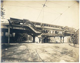
The Washington Street Elevated was an elevated segment of Boston's Massachusetts Bay Transportation Authority subway system, comprising the southern stretch of the Orange Line. It ran from Chinatown through the South End and Roxbury, ending in Forest Hills in Jamaica Plain, Boston.

The Tremont Street subway in Boston's MBTA subway system is the oldest subway tunnel in North America and the third-oldest still in use worldwide to exclusively use electric traction, opening on September 1, 1897. It was originally built, under the supervision of Howard A. Carson as chief engineer, to get streetcar lines off the traffic-clogged streets, instead of as a true rapid transit line. It now forms the central part of the Green Line, connecting Boylston Street to Park Street and Government Center stations.
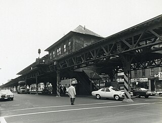
Northampton station was an elevated rapid transit station located above Washington Street at Massachusetts Avenue in the South End neighborhood of Boston, Massachusetts. It served the Washington Street Elevated, part of the MBTA's Orange Line, from 1901 until 1987.

The Peabody Museum of Salem (1915–1992), formerly the Peabody Academy of Science (1865–1915), was a museum and antiquarian society based in Salem, Massachusetts. The academy was organized in part as a successor to the East India Marine Society, which had become moribund but held a large collection of maritime materials in a museum collection at the East India Marine Hall, built in 1825 on Essex Street. The Peabody Museum was merged with the Essex Institute to form the Peabody Essex Museum in 1992. The East India Marine Hall, now embedded within the latter's modern structure, was designated a National Historic Landmark in 1965 in recognition of this heritage, which represents the nation's oldest continuously-operating museum collection.

The Peabody is a historic apartment building at 195-197 Ashmont Street in the Dorchester neighborhood of Boston, Massachusetts. The 3+1⁄2-story Tudor Revival brick building was designed by Edwin J. Lewis Jr., a local architect, and built in 1896–97. It is named for its original owners Oliver and Mary Lothrop Peabody, who were, significant proponents of the development of the area. It was built as a complement to the nearby All Saints' Church, which also stands facing Peabody Square, and was financially supported by the Olivers.

The Society of the Congregational Church of Great Barrington is an historic church building and parish house located at 241 and 251 Main Street in Great Barrington, Massachusetts. It is the fourth church of a congregation whose first meetings were held in 1743.

The Essex Institute Historic District is a historic district at 134-132, 128, 126 Essex Street and 13 Washington Square West in Salem, Massachusetts. It consists of a compact group of properties associated with the Essex Institute, founded in 1848 and merged in 1992 into the Peabody Essex Museum. Listed by increasing street number, they are: the Crowninshield-Bentley House, the Gardner-Pingree House, the John Tucker Daland House, and the Phillips Library. The John Ward House, which fronts on Brown Street but shares the 132 Essex Street address, is another National Historic Landmark within the district. The Andrew Safford House at 13 Washington Square West, built in 1819, was said to be the most expensive home in New England at the time.

Peabody City Hall is the historic city hall of Peabody, Massachusetts. It is located at 24 Lowell Street, near Peabody Square.

The Waltham Gas and Electric Company Generating Plant is a historic power company generator building at 96 Pine Street in Waltham, Massachusetts. Built c. 1900–1909, this large concrete-and-stone building is an essentially unaltered early power generation plant, although all of its window openings have been filled with concrete. It originally housed a steam power generator, and was sold by Waltham Gas and Electric to Boston Edison, who converted it to an electrical substation in 1917, a role it continues to fulfill.

The Waltham Gas Light Company was a historic industrial facility located at 2 Cooper Street in Waltham, Massachusetts. It was one of the oldest industrial complexes on the South Side of the city, with brick buildings dating to 1854–55, not long after the founding of the company. The Waltham Gas Light Company was founded in 1853 to provide natural gas for "illumination, fuel, and power" to the area. In 1886 the company added an electrical generation plant to the property, which lay in an area roughly bounded by the Charles River, the Boston & Maine railroad right-of-way, and Cooper Street, which now serves an access to the municipal parking garage just west of the company property. The company shut down in 1909, transferring its electrical business to Boston Edison, which still operates an electrical substation in a nearby former company building. The other company buildings were converted to other manufacturing uses, and were demolished in 2007.

Saint Mary of the Assumption Church, Rectory, School and Convent is a historic church complex at 67 Harvard Street, and 3 and 5 Linden Place, in Brookline, Massachusetts in the Archdiocese of Boston. It was the first Roman Catholic Church in Brookline, and the first in the nation to bear the name. Most of its buildings were built between 1880 and 1906, and are reflective of the growth of the area's Irish immigrant community during that time. The complex was listed on the National Register of Historic Places in 1985.
This is a timeline of the history of the city of Salem, Massachusetts, United States.

The Roslindale Substation is a historic electrical substation building at 4228 Washington Street in the center of the Roslindale village of Boston, Massachusetts. The brick Classical Revival building was constructed in 1911 by the Boston Elevated Railway (BERy), a predecessor to today's MBTA. The monumental building is 80 feet (24 m) long, 50 feet (15 m) wide, and 46 feet (14 m) high. The building was designed by Robert S. Peabody of Peabody and Stearns, and built by Stone & Webster. The building was use by the Boston Elevated and its successors to provide AC to DC conversion for street cars until 1971. It is one of four substations built by the BERy to survive.
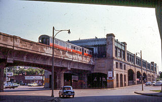
Egleston was a rapid transit station in Boston, Massachusetts. It served the Washington Street Elevated, part of the MBTA's Orange Line. It was located over Egleston Square at the intersection of Washington Street and Columbus Avenue in the Roxbury neighborhood. The station opened in November 1909, and closed in April 1987 when the Orange Line was rerouted to the west along the Southwest Corridor.

Fort Hill is a 0.4 square mile neighborhood and historic district of Roxbury, in Boston, Massachusetts. The approximate boundaries of Fort Hill are Malcolm X Boulevard on the north, Washington Street on the southeast, and Columbus Avenue on the southwest.

The Walnut Park Historic District is a historic district encompassing a cluster of multifamily brick buildings in the Roxbury neighborhood of Boston, Massachusetts. Roughly centered on the junction of Walnut Park and Waldren Road, the area was developed in the early 20th century during a major Jewish migration, and includes a fine sample of Colonial Revival architecture. The district was listed on the National Register of Historic Places in 2022.


