Aquarium station is an underground rapid transit station on the MBTA Blue Line in Boston, Massachusetts, United States. It is located under State Street at Atlantic Avenue on the eastern edge of Boston's Financial District near Boston Harbor. The station is named for the nearby New England Aquarium. It is adjacent to Long Wharf, which is used by two MBTA Boat lines. The station has two side platforms serving the two tracks of the Blue Line; an arched ceiling runs the length of the platform level. With the platforms 50 feet (15 m) below street level, it is the second-deepest station on the MBTA system.
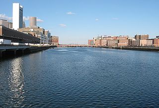
Fort Point Channel is a maritime channel separating South Boston from downtown Boston, Massachusetts, feeding into Boston Harbor. The south part of it has been gradually filled in for use by the South Bay rail yard and several highways. At its south end, the channel once widened into South Bay, from which the Roxbury Canal continued southwest where the Massachusetts Avenue Connector is now. The Boston Tea Party occurred at its northern end. The channel is surrounded by the Fort Point neighborhood, which is also named after the same colonial-era fort.

The Salem Maritime National Historic Site is a National Historic Site consisting of 12 historic structures, one replica tall-ship, and about 9 acres of land along the waterfront of Salem Harbor in Salem, Massachusetts, United States. Salem Maritime is the first National Historic Site established in the United States. It interprets the Triangle Trade during the colonial period, in cotton, rum, sugar and slaves; the actions of privateers during the American Revolution; and global maritime trade with the Far East, after independence. The National Park Service manages both the National Historic Site and a Regional Visitor Center in downtown Salem. The National Park Service (NPS) is an agency of the United States Department of the Interior.

Long Wharf is a historic American pier in Boston, Massachusetts, built between 1710 and 1721. It once extended from State Street nearly a half-mile into Boston Harbor; today, the much-shortened wharf functions as a dock for passenger ferries and sightseeing boats.

The Leather District is a neighborhood of Boston near South Street, between the Financial District and Chinatown. The Leather District is a tightly defined area bounded by Kneeland Street to the south, Essex Street to the north, Atlantic Avenue to the east and Lincoln Street to the west. It is so named due to the dominance of the leather industry in the late 19th century.

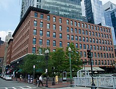
Russia Wharf is a completed high-rise building in downtown Boston, Massachusetts. The building rises 436 feet (133 m) and contains 32 floors. Construction began in 2006 and was finished in early 2011; as such, the structure is one of the most recently completed high-rises in the city. Russia Wharf now stands as the 35th-tallest building in the city. The architectural firm that designed the building is Childs Bertman Tseckares Inc., of Boston, Massachusetts. The civil engineer, also responsible for managing permitting was Vanasse Hangen Brustlin, Inc. of Watertown, Massachusetts. The mixed use project includes approximately 709,000 square feet (65,900 m2) of class-A commercial office space and 65 residential units. The site consists of approximately 2.2 acres (8,900 m2). From about 1897 to 2007, the site contained three low-rise mercantile buildings called the Russia, Graphic Arts, and Tufts Buildings. The office tower is being constructed on the site of the Graphic Arts and Tufts Buildings. As of 2009, Boston Properties has begun to refer to the building as Atlantic Wharf.
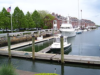
Union Wharf is an historic wharf at 295-353 Commercial Street in the North End of Boston, Massachusetts. The wharf began as a more modest wooden structure in the late 18th century, and was developed with a complex of granite buildings roughly between 1830 and 1850. It was one of the major centers of trade on the Port of Boston in the mid-19th century, and served as a passenger terminal later in the 19th century.

The Armory of the First Corps of Cadets is a historic armory at 97–105 Arlington Street and 130 Columbus Avenue in Boston, Massachusetts. Over the years it has been known as Park Plaza Castle, Castle at Park Plaza, and The Tower.

The Bigelow School is a historic school at 350 West 4th Street in South Boston, Massachusetts. The three-story Classical Revival brick building was designed by Charles J. Bateman and built in 1901. Features include corner quoining, cast concrete window lintels and sills. It was named for John P. Bigelow, mayor of Boston when the first school was built on the site in 1850. It was closed by 1976.

The Codman Square District is a historic district in the Dorchester neighborhood of Boston, Massachusetts. It consists of four of the most prominent properties facing the main Codman Square intersection, where Talbot Avenue and Washington Street cross. The area has a long history as a major civic center in Dorchester, and is now one of the large neighborhood's major commercial hubs. The properties in the district include the 1806 Congregational Church, the 1904 Codman Square branch of the Boston Public Library, the former Girls Latin Academy building, and the Lithgow Building, a commercial brick structure at the southeast corner of the junction that was built in 1899.
Engine House No. 34 is a historic fire station at 444 Western Avenue near the corner of Waverly Street in the Brighton neighborhood of Boston, Massachusetts. The station, a 2+1⁄2-story brick and brownstone structure, was designed by Charles J. Bateman and built in 1888. It is one of a small number of Richardson Romanesque structures in the neighborhood, and features an engine entrance recessed behind a large round arch set asymmetrically on the main facade. The roof is gabled, although it has a hipped section above, with a large hipped projection to the left.

The Fort Point Channel Historic District is an historic district located along Congress, Summer and A streets in South Boston on the south side of Fort Point Channel.
The Harvard Avenue Fire Station is a historic former fire station on 16 Harvard Avenue in Boston, Massachusetts. The station was designed in 1891 by Harrison H. Atwood, the Boston city architect who also designed the Congress Street Fire Station, It is a hip-roofed two story brick structure with Renaissance and Classical Revival elements. It was the second firehouse built on the site, and housed Engine #41 and Hook and Ladder #14.

St. Mary's Episcopal Church is a parish of the Episcopal Church, noted for its historic church at 14–16 Cushing Avenue in the Dorchester neighborhood of Boston, Massachusetts. Founded in 1847, it remains an active congregation of the Episcopal Diocese of Massachusetts.
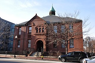
The Joshua Bates School is a historic school building at 731 Harrison Avenue in the South End neighborhood of Boston, Massachusetts. The 2+1⁄2-story Romanesque Revival brick building was designed by Arthur H. Vinal and built in 1884. It was named for financier and major benefactor of the Boston Public Library Joshua Bates. The school was closed in 1975 as a consequence of court-ordered desegregation actions. It was rehabilitated and adapted for use as artists' studios in 2003.

Congress Street in Boston, Massachusetts, is located in the Financial District and South Boston. It was first named in 1800. It was extended in 1854 as far as Atlantic Avenue, and in 1874 across Fort Point Channel into South Boston. Today's Congress Street consists of several segments of streets, previously named Atkinson's Street, Dalton Street, Gray's Alley, Leverett's Lane, Quaker Lane, and Shrimpton's Lane.
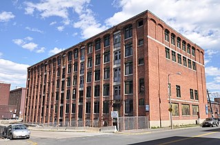
The Terminal Storage Warehouse District is located at Medford and Terminal Streets in the Charlestown neighborhood of Boston, Massachusetts. It includes three large brick warehouse buildings which were built between 1910 and 1913. They are rare surviving elements of the commercial development of the Charlestown waterfront early in the 20th century. They were built by two separate companies which had common ownership. The buildings at 40 and 50 Terminal Street were built by the Terminal Wharf & Railroad Warehouse Company, and that at 267-281 Medford Street was built by the Terminal Storage Warehouse Company. They were built to serve as storage facilities for the transhipment by rail and ship of goods through the port. The buildings were vacated in 1984, and are being rehabilitated after many years of vacancy.

The buildings at 825–829 Blue Hill Avenue are historic apartment buildings in the Mattapan neighborhood of Boston, Massachusetts. The three-story Colonial Revival masonry structures were designed by Samuel Levy and built in 1924 for Herman Barron, during a period in which Boston's Jewish population migrated to the area in large numbers from downtown Boston. The buildings occupy a triangular lot at the corner of Blue Hill Avenue and Calder Street. Both street-facing facades feature alternating projecting and recessed bays, and are laid in seven-course Flemish bond brick. At the corner the building has two single-bay facades, one of which houses an entrance. These faces are ornamented with corner quoining in concrete. The main entrances of the buildings are on Blue Hill Avenue, sheltered by gabled porticos supported by Tuscan columns.

Central Wharf is a historic pier in Boston, Massachusetts. Built in 1815–1816 between Long Wharf and India Wharf, it originally extended from India Street nearly a quarter-mile into Boston Harbor. Today, the much-shortened wharf serves as the home of the New England Aquarium.

The Boston Fish Pier is the central site for the fishing industry based in Boston, Massachusetts. Located on Northern Avenue in South Boston in Boston's Inner Harbor, the pier has played this role since its establishment in 1910. In the 1920s, it was home to one of the largest fishing fleets in the eastern United States, processing 250 million pounds of fish. The pier and its associated buildings were listed on the National Register of Historic Places in 2017.