The Boston Public Library is a municipal public library system in Boston, Massachusetts, founded in 1848. The Boston Public Library is also Massachusetts' Library for the Commonwealth, meaning all adult residents of the state are entitled to borrowing and research privileges, and the library receives state funding. The Boston Public Library contains approximately 24 million items, making it the third-largest public library in the United States behind the federal Library of Congress and New York Public Library, which is also privately endowed. In 2014, the library held more than 10,000 programs, all free to the public, and lent 3.7 million materials.

Harvard station is a rapid transit and bus transfer station in Cambridge, Massachusetts. Located at Harvard Square, it serves the MBTA's Red Line subway system as well as MBTA buses. Harvard averaged 18,528 entries each weekday in FY2019, making it the third-busiest MBTA station after Downtown Crossing and South Station. Five of the fifteen key MBTA bus routes stop at the station.

Charles/MGH station is a rapid transit station on the MBTA Red Line, elevated above Charles Circle on the east end of the Longfellow Bridge in the West End neighborhood of Boston, Massachusetts. The station is named for Charles Circle and the adjacent Massachusetts General Hospital (MGH) campus. It has two side platforms, with a glass-walled headhouse structure inside Charles Circle. Charles/MGH station is fully accessible.

Roslindale is a primarily residential neighborhood of Boston, Massachusetts, United States, bordered by Jamaica Plain, Hyde Park, West Roxbury and Mattapan. It is served by an MBTA Commuter Rail line, several MBTA bus lines and the MBTA Orange Line in nearby Jamaica Plain. Roslindale has its own branch of the Boston Public Library, the neighborhood is covered by Boston Police District E-5 in West Roxbury, Boston EMS Ambulance 17 is stationed in Roslindale, and the Boston Fire Department has a station on Canterbury Street which houses Ladder 16, Engine 53 & District Chief 12. Roslindale's original Engine Company 45, was deactivated on April 10, 1981, due to budget cuts. Roslindale was once called the "garden suburb" of Boston. The portion of the Arnold Arboretum south of Bussey Street is located in Roslindale.

The Old State House a/k/a the Old Provincial State House, is a historic building in Boston, Massachusetts, built in 1713. It was the seat of the Massachusetts General Court until 1798. It is located at the intersection of Washington and State Streets and is one of the oldest public buildings in the United States.
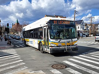
The Massachusetts Bay Transportation Authority (MBTA) operates 152 bus routes in the Greater Boston area. The MBTA has a policy objective to provide transit service within walking distance for all residents living in areas with population densities greater than 5,000 inhabitants per square mile (1,900/km2) within the MBTA's service district. Much of this service is provided by bus. In 2023, the system had a ridership of 91,459,700, or about 310,700 per weekday as of the first quarter of 2024.

Boston College station is a light rail station on the MBTA Green Line B branch. It is located at St. Ignatius Square on the Boston College campus near the intersection of Commonwealth Avenue and Lake Street, on the border between the Brighton neighborhood of Boston and the Chestnut Hill neighborhood of Newton, Massachusetts. Originally opened in 1896, it has been the terminus of the Commonwealth Avenue line since 1900. The current station is planned to be replaced by a new station located in the median of Commonwealth Avenue just east of Lake Street.

The Rose Fitzgerald Kennedy Greenway is a linear park located in several Downtown Boston neighborhoods. It consists of landscaped gardens, promenades, plazas, fountains, art, and specialty lighting systems that stretch over one mile through Chinatown, the Financial District, the Waterfront, and North End neighborhoods. Officially opened in October 2008, the 17-acre Greenway sits on land created from demolition of the John F. Fitzgerald Expressway as part of the Big Dig project.

Hynes Convention Center station is an underground light rail station on the Massachusetts Bay Transportation Authority (MBTA) Green Line. It is located at the intersection of Newbury Street and Massachusetts Avenue near the western end of the Back Bay neighborhood of Boston, Massachusetts. The station is named for the Hynes Convention Center, which is located about 700 feet (210 m) to the east along Boylston Street. It has two side platforms serving the two tracks of the Boylston Street subway, which are used by the Green Line B branch, C branch, and D branch. The main entrance to the station from Massachusetts Avenue leads to a fare lobby under the 360 Newbury Street building.

Coolidge Corner station is a light rail stop on the MBTA Green Line C branch, located at the intersection of Beacon Street and Harvard Street in the Coolidge Corner neighborhood of Brookline, Massachusetts. With 3,440 daily boardings by a 2011 count, it had more than twice the ridership of any other surface station on the branch.

The Boston Elevated Railway (BERy) was a streetcar and rapid transit railroad operated on, above, and below, the streets of Boston, Massachusetts and surrounding communities. Founded in 1894, it eventually acquired the West End Street Railway via lease and merger to become the city's primary mass transit provider. Its modern successor is the state-run Massachusetts Bay Transportation Authority (MBTA), which continues to operate in part on infrastructure developed by BERy and its predecessors.

The Arnold Arboretum of Harvard University is a botanical research institution and free public park, located in the Jamaica Plain and Roslindale neighborhoods of Boston, Massachusetts. Established in 1872, it is the oldest public arboretum in North America. The landscape was designed by Charles Sprague Sargent and Frederick Law Olmsted and is the second largest "link" in the Emerald Necklace. The Arnold Arboretum's collection of temperate trees, shrubs, and vines has an emphasis on the plants of the eastern United States and eastern Asia, where arboretum staff and colleagues are sourcing new material on plant collecting expeditions. The arboretum supports research in its landscape and in its Weld Hill Research Building.

Forest Hills is a part of the Jamaica Plain neighborhood of Boston, Massachusetts, United States. Forest Hills is characterized by hilly terrain and wooded areas within and adjacent to its borders. In general, the area slopes upward from Hyde Park Ave and downward from Walk Hill Street.
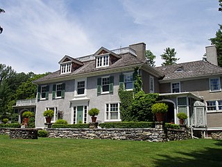
Chesterwood was the summer estate and studio of American sculptor Daniel Chester French (1850–1931) located at 4 Williamsville Road in Stockbridge, Massachusetts. Most of French's originally 150-acre (61 ha) estate is now owned by the National Trust for Historic Preservation, which operates the property as a museum and sculpture garden. The property was designated a National Historic Landmark in 1965 in recognition of French's importance in American sculpture.

Peabody City Hall is the historic city hall of Peabody, Massachusetts. It is located at 24 Lowell Street, near Peabody Square.
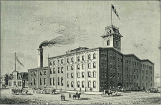
The William Ulmer Brewery is a brewery complex in Bushwick, Brooklyn, New York City. It consists of four buildings—an office, a brew house, an engine–machine house, and a stable–storage house—all constructed between 1872 and 1890 in the German round-arch style. The site is bounded by Belvidere Street to the southeast, Beaver Street to the northeast, and Locust Street to the northwest, with the address 31 Belvidere Street. The main brew house, the engine–machine house, and the office building were designed by Brooklyn architect Theobald Engelhardt, while the stable–storage house was designed by Frederick Wunder.

The Phillips Library of the Peabody Essex Museum (PEM) is a rare books and special collections library. It is made up of the collections of the former Peabody Museum of Salem and the Essex Institute. Both had libraries named for members of the Phillips family.
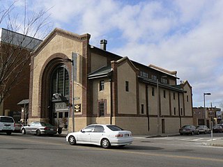
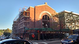
The Egleston Substation is a historic electrical substation building located at 3025 Washington Street in the Roxbury neighborhood of Boston, Massachusetts, just north of Egleston Square. The brick Renaissance Revival building was constructed in 1909 by the Boston Elevated Railway during the extension of the Washington Street Elevated to Forest Hills.

The Conductor's Building is a former Boston Elevated Railway (BERy) administrative building, located on Bennett Alley between Mount Auburn Street and Bennett Street near Harvard Square in Cambridge, Massachusetts. Built in 1912 as the headquarters of BERy's 7th Division, it is the only original building surviving from the construction of the Cambridge subway. After being renovated from 2014 to 2017 as part of an adjacent hotel project, the building was used as a restaurant from April 2017 to August 2018. Under the name Boston Elevated R.Y. Offices, it is a contributing property to the Harvard Square Historic District.

The Turtle Bay Gardens Historic District is a collection of twenty rowhouses in the Turtle Bay neighborhood of Manhattan in New York City. They consist of eleven houses on the south side of 49th Street and nine on the north side of 48th Street, between Second and Third Avenues. The rowhouses, dating from the 1860s, were renovated between 1918 and 1920 by Charlotte Hunnewell Sorchan to plans by Clarence Dean.


