El Dara, Illinois

Last updated

El Dara
Pike County Illinois Incorporated and Unincorporated areas El Dara Highlighted.svg
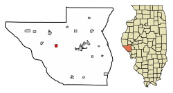
Location of El Dara in Pike County, Illinois.
Illinois in United States (US48).svg
Location of Illinois in the United States
Coordinates: 39°37′20″N90°59′33″W / 39.62222°N 90.99250°W / 39.62222; -90.99250
CountryUnited States
StateIllinois
County Pike
Area
[1]
  Total1.01 sq mi (2.62 km2)
  Land1.01 sq mi (2.62 km2)
  Water0.00 sq mi (0.00 km2)
Elevation
[2]
738 ft (225 m)
Population
 (2020)
  Total63
  Density62.31/sq mi (24.05/km2)
Time zone UTC-6 (CST)
  Summer (DST) UTC-5 (CDT)
ZIP Code(s)
62312
Area code 217
GNIS ID2398792 [2]
FIPS code 17-22957
Wikimedia CommonsEl Dara, Illinois

El Dara is a village in Pike County, Illinois, United States. The population was 78 at the 2010 census, down from 89 in 2000.

Contents

Geography

El Dara is located at 39°37′20″N90°59′33″W / 39.62222°N 90.99250°W / 39.62222; -90.99250 (39.622207, -90.992452). [3]

According to the 2010 census, El Dara has a total area of 0.97 square miles (2.51 km2), all land. [4]

Demographics

Historical population
CensusPop.Note
1880 307
1890 241−21.5%
1900 2493.3%
1910 195−21.7%
1920 165−15.4%
1930 149−9.7%
1940 1586.0%
1950 137−13.3%
1960 98−28.5%
1970 82−16.3%
1980 876.1%
1990 948.0%
2000 89−5.3%
2010 78−12.4%
2020 63−19.2%
U.S. Decennial Census [5]

As of the 2000 United States Census, [6] there were 89 people, 32 households, and 24 families residing in the village. The population density was 92.0 inhabitants per square mile (35.5/km2). There were 35 housing units at an average density of 36.2 per square mile (14.0/km2). The racial makeup of the village was 100.00% White.

There were 32 households, out of which 37.5% had children under the age of 18 living with them, 75.0% were married couples living together, 3.1% had a female householder with no husband present, and 21.9% were non-families. 21.9% of all households were made up of individuals, and 21.9% had someone living alone who was 65 years of age or older. The average household size was 2.78 and the average family size was 3.24.

In the village, the population was spread out, with 33.7% under the age of 18, 2.2% from 18 to 24, 25.8% from 25 to 44, 23.6% from 45 to 64, and 14.6% who were 65 years of age or older. The median age was 35 years. For every 100 females, there were 74.5 males. For every 100 females age 18 and over, there were 73.5 males.

The median income for a household in the village was $36,250, and the median income for a family was $48,750. Males had a median income of $30,313 versus $15,000 for females. The per capita income for the village was $11,422. There were 7.7% of families and 9.6% of the population living below the poverty line, including 8.2% of under eighteens and 16.7% of those over 64.

Related Research Articles

<span class="mw-page-title-main">Scottville, Illinois</span> Village in Illinois, United States

Scottville is a village in Macoupin County, Illinois, United States. The population was 93 at the 2020 census.

<span class="mw-page-title-main">Baylis, Illinois</span> Village in Illinois, United States

Baylis is a village in Pike County, Illinois, United States. The population was 200 at the 2010 census.

<span class="mw-page-title-main">Florence, Illinois</span> Village in Illinois, United States

Florence is a village in Pike County, Illinois, United States. The population was 17 at the 2020 census, making Florence the second-least populated municipality in Illinois.

<span class="mw-page-title-main">Milton, Illinois</span> Village in Illinois, United States

Milton is a village in Pike County, Illinois, United States. The population was 271 at the 2010 census, a decline from 274 in 2000.

<span class="mw-page-title-main">New Salem, Pike County, Illinois</span> Village in Illinois, United States

New Salem is a village in Pike County, Illinois, United States. The population was 136 at the 2000 census.

<span class="mw-page-title-main">Pearl, Illinois</span> Village in Illinois, United States

Pearl is a village in Pike County, Illinois, United States. The population was 103 at the 2020 census. The village, settled in the late 19th century, is named after pearl buttons drilled from the large supply of native mussels that once lived in the nearby Illinois River.

<span class="mw-page-title-main">Pleasant Hill, Illinois</span> Village in Illinois, United States

Pleasant Hill is a village in Pike County, Illinois, United States. The population was 966 at the 2010 census.

<span class="mw-page-title-main">Valley City, Illinois</span> Village in Illinois, United States

Valley City is a village in Pike County, Illinois, United States. The population was 14 at the 2020 census, making Valley City the smallest incorporated place in Illinois in terms of population. As of 2024, the population is 13. In late December 2015 and early January 2016 the village flooded, leaving many roads underwater.

<span class="mw-page-title-main">Smithton, Illinois</span> Village in Illinois, United States

Smithton is a village in St. Clair County, Illinois, United States. The population was 4,006 in the 2020 United States Census. It is part of the Metro East region of Greater Saint Louis.

<span class="mw-page-title-main">Dresden, Kansas</span> City in Decatur County, Kansas

Dresden is a city in Decatur County, Kansas, United States. As of the 2020 census, the population of the city was 43.

<span class="mw-page-title-main">Verde Village, Arizona</span> CDP in Yavapai County, Arizona

Verde Village is a census-designated place (CDP) in Yavapai County, Arizona, United States. The population was 11,605 at the 2010 census. It is a retirement and bedroom community for Cottonwood.

<span class="mw-page-title-main">Sunfield, Michigan</span> Village in Michigan, United States

Sunfield is a village in Eaton County in the U.S. state of Michigan. The population was 518 at the 2020 U.S. Census. The village is located within Sunfield Township.

<span class="mw-page-title-main">Mackenzie, Missouri</span> Village in Missouri, United States

Mackenzie is an unincorporated community in St. Louis County, Missouri, United States. The population was 134 at the 2010 census.

<span class="mw-page-title-main">Valleyview, Ohio</span> Village in Ohio, United States

Valleyview is a village in Franklin County, Ohio, United States. The population was 669 at the 2020 census.

<span class="mw-page-title-main">Frailey Township, Pennsylvania</span> Township in Pennsylvania, United States

Frailey Township is a township in Schuylkill County, Pennsylvania, United States. The population was 420 at the 2020 census.

<span class="mw-page-title-main">Bloxom, Virginia</span> Town in Virginia, United States

Bloxom is a town in Accomack County, Virginia, United States. The population was 387 at the 2010 census.

<span class="mw-page-title-main">Rewey, Wisconsin</span> Village in Wisconsin, United States

Rewey is a village in Iowa County, Wisconsin, United States. The population was 292 at the 2010 census. It is part of the Madison Metropolitan Statistical Area.

<span class="mw-page-title-main">Dorchester, Wisconsin</span> Village in Wisconsin, United States

Dorchester is a village in Clark and Marathon counties in the U.S. state of Wisconsin, along the 45th parallel. It is part of the Wausau, Wisconsin Metropolitan Statistical Area. The population was 876 at the 2010 census. Of this, 871 were in Clark County, and only 5 were in Marathon County.

<span class="mw-page-title-main">Mount Hope, Wisconsin</span> Village in Wisconsin, United States

Mount Hope is a village in Grant County, Wisconsin, United States. The population was 225 at the 2010 census. The village is located within the Town of Mount Hope.

<span class="mw-page-title-main">Wilton, Wisconsin</span> Village in Wisconsin, United States

Wilton is a village in Monroe County, Wisconsin, United States. The population was 504 at the 2010 census. The village is located partially within the Town of Wilton and partially within the Town of Wellington.

References

  1. "2020 U.S. Gazetteer Files". United States Census Bureau. Retrieved March 15, 2022.
  2. 1 2 U.S. Geological Survey Geographic Names Information System: El Dara, Illinois
  3. "US Gazetteer files: 2010, 2000, and 1990". United States Census Bureau. February 12, 2011. Retrieved April 23, 2011.
  4. "G001 - Geographic Identifiers - 2010 Census Summary File 1". United States Census Bureau. Archived from the original on February 13, 2020. Retrieved August 3, 2015.
  5. "Census of Population and Housing". Census.gov. Retrieved June 4, 2015.
  6. "U.S. Census website". United States Census Bureau . Retrieved January 31, 2008.