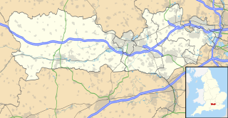
Berkshire is a county in South East England. One of the home counties, Berkshire was recognised by the Queen as the Royal County of Berkshire in 1957 because of the presence of Windsor Castle, and letters patent were issued in 1974. Berkshire is a county of historic origin, a ceremonial county and a non-metropolitan county without a county council. The county town is Reading.

The River Pang is a small chalk stream river in the west of the English county of Berkshire, and a tributary of the River Thames. It runs for approximately 23 kilometres (14 mi) from its source near the village of Compton to its confluence with the Thames in the village of Pangbourne.

The Test Way is a 44-mile (71 km) long-distance footpath in England from Walbury Hill in West Berkshire to Eling in Hampshire, which follows much of the course of the River Test.

World's End is a hamlet in Berkshire, England. It is in the district of West Berkshire, near the A34 road north of Newbury. To the north is the village of Beedon ; to the south lie Downend and Chieveley.

Ashmore Green is a small hamlet in Berkshire, England. It is situated just to the west of the village of Cold Ash and to the north of Thatcham in the West Berkshire district.

Upper Lambourn is a small village in the county of Berkshire, England. The village is situated in the civil parish of Lambourn, and is 1.2 miles (2 km) to the north-west of the village of Lambourn, just off the Lambourn to Shrivenham road. The parish is within the district of West Berkshire, close to the point where the counties of Berkshire, Oxfordshire and Wiltshire meet.

Marsh Benham is a village in the civil parish of Speen in the county of Berkshire, England. It is situated in the unitary authority of West Berkshire, just west of Newbury.

Ashmansworth is a village and civil parish in the Basingstoke and Deane district of the English county of Hampshire.

West Berkshire is a unitary authority in Berkshire, England. Until 1 April 1998 it was a non-metropolitan district.

Bartley Water is a two-branch small river in the New Forest district of Hampshire, England. It drains the north and north-east of the New Forest National Park up to the A31 road, a watershed and two villages against the north-east side of the park.

Gainfield is a small ribbon development in Buckland civil parish about 4 miles (6.4 km) east of Faringdon in the Vale of the White Horse District of England. It was part of Berkshire until the 1974 boundary changes transferred it to Oxfordshire.

Farley Hill is a village in the county of Berkshire, England. For local government purposes, the village is within the civil parish of Swallowfield, which in turn is within the unitary authority of Wokingham.

Beedon Common is a hamlet and former common in the English county of Berkshire, within the civil parish of Beedon. The settlement lies close to the A34 road, and is located approximately 6 miles (9.7 km) north of Newbury.

Benham Hill is a settlement in Berkshire, England, and is adjoined to both Thatcham and Newbury. The settlement lies on the A4 road, and is previously the site of the Turnpike School.

Brightwalton Green is a hamlet in the civil parish of Brightwalton in the county of Berkshire, England. The settlement lies near to the A338 road, and is situated approximately 8 miles (13 km) north-west of Newbury.

Colthrop is a suburb of the town of Thatcham in the English county of Berkshire, England.

Crockham Heath is a small village in Berkshire, England. Crockham Heath is part of the civil parish of Enborne. The settlement lies near to the A34 road, and is located approximately 3 miles (4.8 km) south-west of Newbury where administration occurs.

Enborne Row is a hamlet in Berkshire, England, located on the county's border with Hampshire. The hamlet is within the civil parish of Enborne. The settlement lies next to the A34 road, and is located approximately 3 miles (4.8 km) south-west of Newbury.

Wash Water is a hamlet on the border of Berkshire, and Hampshire. It is divided between the civil parishes of Enborne, Newbury, Highclere and East Woodhay. The settlement lies adjacent to the A343 and A34 highways, approximately 3 miles (4.8 km) south-south-west of Newbury.

Dean Court is a suburb 2 miles (3.2 km) west of the centre of Oxford, England. Dean Court was part of Berkshire until the 1974 local government boundary changes transferred it to Oxfordshire.


