Related Research Articles

Lake Ellesmere / Te Waihora is a broad, shallow coastal lake or waituna, in the Canterbury region of the South Island of New Zealand. It is directly to the west of Banks Peninsula, separated from the Pacific Ocean by the long, narrow, sandy Kaitorete Spit, or more correctly Kaitorete Barrier. It lies partially in extreme southeastern Selwyn District and partially in the southwestern extension of the former Banks Peninsula District, which now is a ward in the city of Christchurch. The lake holds high historical and cultural significance to the indigenous Māori population and the traditional Māori name Te Waihora, means spreading waters. It has officially had a dual English/Māori name since at least 1938.
James Frederick Stuart-Wortley JP was a politician in New Zealand and the UK. He was New Zealand's inaugural Baby of the House and remains the youngest member of parliament in the country's history; in fact he was too young to even be legally elected.

The Selwyn River flows through the Selwyn District of Canterbury in the South Island of New Zealand.

Leeston is a town on the Canterbury Plains in the South Island of New Zealand. It is located 30 kilometres southwest of Christchurch, between the shore of Lake Ellesmere / Te Waihora and the mouth of the Rakaia River. The town is home to a growing number of services which have increased and diversified along with the population. Leeston has a supermarket, schools, churches, hospital, gym, cafes, restaurants, medical centre, pharmacy and post office. The Selwyn District Council currently has a service office in Leeston, after the headquarters was shifted to Rolleston.

The Rakaia River is in the Canterbury Plains in New Zealand's South Island. The Rakaia River is one of the largest braided rivers in New Zealand. The Rakaia River has a mean flow of 203 cubic metres per second (7,200 cu ft/s) and a mean annual seven-day low flow of 87 m3/s (3,100 cu ft/s). In the 1850s, European settlers named it the Cholmondeley River, but this name lapsed into disuse. The name Rakaia comes from Māori "Ō Rakaia", meaning the place where people were arranged by ranks.

Selwyn District is a predominantly rural district in central Canterbury, on the east coast of New Zealand's South Island. It is named after the Selwyn River / Waikirikiri, which is in turn named after Bishop George Selwyn, the first Anglican bishop of New Zealand who, in 1843 and 1844, travelled the length of the country by horse, foot, boat and canoe, leaving in his wake a sprinkling of locations that now bear his name.
Ellesmere may refer to:
Ashburton was a New Zealand electorate, first created in 1881 and centred on the South Island town of Ashburton.

Port Levy is a long, sheltered bay and settlement on Banks Peninsula in Canterbury, New Zealand. The current population is under 100, but in the mid-19th century it was the largest Māori settlement in Canterbury with a population of about 400 people. It is named after Solomon Levey, an Australian merchant and ship owner who sent a number of trading vessels to the Banks Peninsula area during the 1820s.
John McLachlan was a New Zealand Member of Parliament for Ashburton in the South Island.

The Halswell River is a river in the Canterbury region of New Zealand.

The L II River is a small spring-fed river in Canterbury, New Zealand. It rises near Lincoln and flows through very flat farmland, mostly fed by land drainage ditches before emptying into Lake Ellesmere / Te Waihora just east of the mouth of the Selwyn River / Waikirikiri.
Selwyn District Council is the territorial authority for the Selwyn District of New Zealand. The council was formed in 1989. A Selwyn County Council previously operated in the area between 1876 and 1910.
Ellesmere was a parliamentary electorate in the Canterbury region of New Zealand. It existed for two periods between 1861 and 1928 and was represented by six Members of Parliament.

John Anderson was the second Mayor of Christchurch in New Zealand 1868–1869, and a successful businessman. He had a close connection with three buildings that have later received Category I heritage registrations by Heritage New Zealand. Two of these buildings were demolished following the February 2011 Christchurch earthquake.
Alfred Cox was a 19th-century runholder and Member of the New Zealand House of Representatives. Born in New South Wales into an upper middle class military family, he was sent home to England to learn about farming. Upon returning to New South Wales, he heard about the large profits that were possible in South Canterbury and bought licences for land that he had not seen. He stocked the land, put a manager in charge and made another trip to England with his wife and their, at that time, small family. He moved to New Zealand permanently in 1857 and lived on his large farm, Raukapuka, which stretched from the sea to the foothills, and of which the homestead was located in present-day Geraldine. He sold his South Canterbury interests and moved to the Waikato, where he bought large land holdings in Hamilton and Thames. He tried to drain his swamp land and lost a lot of money with those ventures. He sold up in 1882 and moved to Christchurch, where he retired.
Walter Harper was Dean of Christchurch from 1901 until 1913.

The Canterbury District Health Board was a district health board with the focus on providing healthcare to the Canterbury region of New Zealand, north of the Rangitata River. It was responsible for roughly 579,000 residents, or 12% of New Zealand's population. The Canterbury District Health Board covered a territory of 26,881 square kilometers and was divided between six territorial local authorities. In July 2022, the Canterbury DHB was merged into the national health service Te Whatu Ora.

Lake Tennyson is a glacial high-country lake in Canterbury, New Zealand. The first European settler to see the lake was Frederick Weld in 1853, who also named it. The headwaters of the Waiau Toa / Clarence River are just to the north, and the river flows through Lake Tennyson.
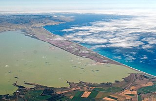
A waituna is a freshwater coastal lagoon on a mixed sand and gravel (MSG) beach, formed where a braided river meets a coastline affected by longshore drift. This type of waterbody is neither a true lake, lagoon nor estuary.
References
- ↑ "Selwyn wards maps and boundaries". Selwyn District Council . Retrieved 28 November 2022.
- ↑ Wilson, John (17 August 2015). "Canterbury places – Ellesmere district". Te Ara: The Encyclopedia of New Zealand . Retrieved 29 November 2022.
- ↑ "Ellesmere Anglican Parish of NZ". Ellesmere Anglican Parish. Retrieved 28 November 2022.
- ↑ Macdonald, George. "Dean Walter Harper". Macdonald Dictionary. Canterbury Museum . Retrieved 29 November 2022.
- ↑ Wilson, James Oakley (1985) [First published in 1913]. New Zealand Parliamentary Record, 1840–1984 (4th ed.). Wellington: V.R. Ward, Govt. Printer. p. 263. OCLC 154283103.
43°39′50″S172°21′24″E / 43.66389°S 172.35667°E
| | This Canterbury Region-related geography article is a stub. You can help Wikipedia by expanding it. |