Erie Plain

Last updated
The Erie Plain in Ohio, defined by Lake Erie and the Portage and Marshall Escarpments (in red). Erie Plain.jpg
The Erie Plain in Ohio, defined by Lake Erie and the Portage and Marshall Escarpments (in red).

The Erie Plain is a lacustrine plain that borders Lake Erie in North America. From Buffalo, New York, to Cleveland, Ohio, it is quite narrow (at best only a few miles/kilometers wide), but broadens considerably from Cleveland around Lake Erie to Southern Ontario, where it forms most of the Ontario peninsula. The Erie Plain was used in the United States as a natural gateway to the North American interior, and in both the United States and Canada the plain is heavily populated and provides very fertile agricultural land.

Contents

Creation of the plain

Early Lake Erie laid down some of the sediments that are the Erie Plain today. Glacial lakes.jpg
Early Lake Erie laid down some of the sediments that are the Erie Plain today.

The Erie Plain is a lacustrine plain [1] consisting largely of sediment laid down by a series of proglacial lakes. [2] These existed in the late Pleistocene Epoch, about 25,000 years ago to about 11,700 years ago, and were created by glaciers of the Wisconsin glaciation (the last ice age). [3] The largest of these was Lake Whittlesey. In some places in Pennsylvania and Ohio, the Erie Plain is broken by the very slight former shoreline of Lake Warren. [4] This glacial sediment was laid atop the Chagrin and the Cleveland shales created in the late Devonian Period (382.5 to 359 million years ago), [5] as well as early Carboniferous Period shale in and west of Cleveland (laid down 359 to 346 million years ago). [6] West of Sandusky, Ohio, these sediments lie atop limestone laid down in the Silurian and Devonian periods. [7]

Due to its lacustrine origin, much of the soil of the Erie Plain contains abundant clay, although in some areas it is quiet sandy where ancient beaches formed. [1] Beneath this relatively thin layer of soil is unconsolidated moraine, soil and rock left behind as the glaciers retreated. [8]

Description

Three geologically distinct plains border Lake Erie. The lowest of these is the Ontario Plain, followed by the Huron Plain and then the Erie Plain. Escarpments separate the plains from one another. Between the Erie Plain and the Appalachian Plateau is the Portage Escarpment. [9]

The Erie Plain begins just east of Auburn, New York, where the Onondaga Escarpment meets the Portage Escarpment. [10] The Onondaga Escarpment sharply distinguishes the Erie Plain from the Huron Plain east of Buffalo. But along the southern side of Lake Erie west of Buffalo, the Onondaga Escarpment is so slight that the Huron Plain and Erie Plain are essentially the same. [11] [12] At Buffalo, the plain narrows to just 2 to 3 miles (3.2 to 4.8 km) wide as the Portage Escarpment moves closer to the Lake Erie shoreline, [13] and remains 2 to 4 miles (3.2 to 6.4 km) wide in Erie County, Pennsylvania. [14] From Erie, Pennsylvania, to Cleveland, the plain broadens to about 4 to 6 miles (6.4 to 9.7 km) [2] and is starkly defined by the Portage Escarpment, [15] which rises in three terraces. [16] [17] The plain remains narrow until just west of Cleveland, where the Portage Escarpment moves to the south, [10] and the definition between the plain and escarpment becomes much less distinct. [18] The escarpment is broken in two places by the valleys of the Great Miami and Scioto rivers. [17] [19] The plain expands to 4 to 5 miles (6.4 to 8.0 km) between the Cuyahoga River and the Rocky River, and to 17 miles (27 km) west of the Rocky River around the southwest and western sides of Lake Erie. [20] All told, the Erie Plain covers about one-fourth of the state of Ohio. [17] The Erie Plain extends into Michigan [1] where the Marshall Escarpment forms the inland boundary between the Erie Plain and the interior uplands. [21] The Erie Plain also covers most of the Southern Ontario peninsula between Lake Erie and Lake Huron. Here, the Niagara Escarpment separates the Erie Plain from the Huron Plain to the north. [10]

In Ohio, the combined Huron-Erie Plain begins at a mean altitude of 573 feet (175 m) above sea level, and gradually rises in a series of slight, rolling hills to more than 1,000 feet (300 m) above sea level. In Ontario, post-glacial rebound has lifted the Huron Plain in the north higher than the Erie Plain in the south. South of Georgian Bay, the Niagara Escarpment lifts the Huron Plain to more than 1,500 feet (460 m) above sea level. [10]

The Erie Plain lacks distinguishing features, except for occasional recessional moraines, and the remnants of proglacial lake beaches and lakeside cliffs. [10] [17] In Pennsylvania, the plain is marked only by a series of slight terraces; the boundary between each marks ancient lake shorelines. [14] Cushing, Leverett, and Van Horn identify at least three moraines between Erie, Pennsylvania, and Ohio's Rocky River: The Cleveland, the Euclid, and the Defiance. [11] West of the Rocky River are three ridges (the North, Middle, and Butternut) roughly paralleling the modern lakeshore, ancient beaches formed by proglacial expansions of Early Lake Erie. [20] In Indiana, the lack of distinguishing features allows the plain to merge with the Mississippi River basin lowlands. [21] On the Niagara Peninsula, morainic ridges interrupt the Erie Plain close to the Niagara Escarpment, as well as a few east–west flowing river valleys. [22]

Settlement and economic development

The Erie Plain connects with the Mohawk Valley in the east, and provides the only natural, low-lying route north of the Gulf Coast to the North American interior from the Atlantic seaboard. Consequently, this area is heavily populated. [18] The city of Cleveland is largely built on sediments which form the Erie Plain. [23]

The Welland Canal cuts north–south across the Erie Plain on the Niagara Peninsula. The Deep Cut on the canal, between Allanburg, and Port Robinson, has created two distinct economic districts in the area. The northern district connects with shipping on Lake Ontario, while the southern district is much more aligned with shipping on Lake Erie. [24]

Settlement of Ohio largely occurred along the Erie Plain, following the natural barrier of the Portage Escarpment. In the far northwest of the state, settlement was inhibited by the poorly drained portion of the Erie Plain known as the Great Black Swamp. This area was heavily forested, but nearly all of this primeval forest (representing half of Ohio's woodlands) was clear-cut by 1900. [25] Although the Erie Plain was Ohio's richest farmland, it was also its least forested by the start of the 20th century. [26] Viticulture on the Erie Plain in Ohio has been extensive, both due to the fertile soil and the temperate climate. [27]

Watershed

Rivers of Ohio, with glacial moraines, showing how the moraines affect the watershed of the Erie Plain. Glacial moraines of Ohio.jpg
Rivers of Ohio, with glacial moraines, showing how the moraines affect the watershed of the Erie Plain.

Lake Erie essentially occupies a depression in the middle of the Erie Plain, [9] with the plain tilted toward the lake. [17] The watershed in Ohio is about 12,000 square miles (31,000 km2). [17] [lower-alpha 1]

The Erie Plain drains into Lake Erie, except for that portion east of Buffalo (which drains into Lake Ontario). [3] Water on the Appalachian Plateau, on the other hand, drains to the Gulf of Mexico. [29] In Ohio, brooks generally cut into the plain 10 to 40 feet (3.0 to 12.2 m), while rivers dig channels 40 to 100 feet (12 to 30 m) deep. [20] The plain is so narrow in Ohio that it has no watershed distinct from that which forms in the Portage Escarpment. [30] The Erie Plain in extreme northwest Ohio is not as well-drained as that in the rest of the state, as glacial moraines partially block water in the area. [17] This area was previously known as the Great Black Swamp, until drained by white settlers in the 1800s. [25]

Much of the Erie Plain lies beneath Lake Erie, [11] which has a relatively shallow average depth of just 62 feet (19 m). [31]

Climate

From the beginning of recordkeeping in the early 1800s to 1921, the average rainfall on the plain was about 34 inches (86 cm) a year, with the rainiest months being June and July and the driest October. [32] Prior to human settlement, the combination of landform and rainfall left the Erie Plain with typical prairie plants. [33] Marshes and shallow lakes formerly dotted the landscape here, but human-caused drainage since 1800 has largely erased these and left highly fertile plains behind. [17] Southeastern Michigan, however, still contains many of these distinctive hardwood forest swamps and marshy prairies. [34]

The relatively flat nature of the plain presents little inhibition to wind and the flow of weather across the plain. However, the large cities which line Lake Erie tend to create urban heat islands which can cause local instabilities. [35] Lake Erie itself, however, tends to lessen the effects of cold arctic air masses coming from the north, making the Erie Plain more temperate. [27]

See also

Proglacial lakes of the Lake Erie Basin

Related Research Articles

<span class="mw-page-title-main">Niagara Escarpment</span> Escarpment in Canada and the United States

The Niagara Escarpment is a long escarpment, or cuesta, in Canada and the United States that starts from the south shore of Lake Ontario westward, circumscribes the top of the Great Lakes Basin running from New York through Ontario, Michigan, and Wisconsin. The escarpment is the cliff over which the Niagara River plunges at Niagara Falls, for which it is named.

<span class="mw-page-title-main">Wisconsin glaciation</span> North American glacial ice sheet

The Wisconsin Glacial Episode, also called the Wisconsin glaciation, was the most recent glacial period of the North American ice sheet complex. This advance included the Cordilleran Ice Sheet, which nucleated in the northern North American Cordillera; the Innuitian ice sheet, which extended across the Canadian Arctic Archipelago; the Greenland ice sheet; and the massive Laurentide Ice Sheet, which covered the high latitudes of central and eastern North America. This advance was synchronous with global glaciation during the last glacial period, including the North American alpine glacier advance, known as the Pinedale glaciation. The Wisconsin glaciation extended from approximately 75,000 to 11,000 years ago, between the Sangamonian Stage and the current interglacial, the Holocene. The maximum ice extent occurred approximately 25,000–21,000 years ago during the last glacial maximum, also known as the Late Wisconsin in North America.

<span class="mw-page-title-main">Great Lakes region</span> Binational region of the United States and Canada

The Great Lakes region of North America is a binational Canadian–American region centered around the Great Lakes that includes eight U.S. states and the Canadian province of Ontario. Canada´s Quebec province is at times included as part of the region because the St. Lawrence River watershed is part of the continuous hydrologic system. The region forms a distinctive historical, economic, and cultural identity. A portion of the region also encompasses the Great Lakes megalopolis.

<span class="mw-page-title-main">Lake Tonawanda</span> Former lake in North America

Lake Tonawanda was a prehistoric lake that existed approximately 10,000 years ago at the end of the last ice age, in Western New York, United States.

<span class="mw-page-title-main">Lake Algonquin</span> Former lake in North America

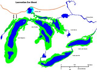
Lake Algonquin was a prehistoric proglacial lake that existed in east-central North America at the time of the last ice age. Parts of the former lake are now Lake Huron, Georgian Bay, Lake Superior, Lake Michigan, Lake Nipigon, and Lake Nipissing.

<span class="mw-page-title-main">Early Lake Erie</span> Former lake in North America

Early Lake Erie was a prehistoric proglacial lake that existed at the end of the last ice age approximately 13,000 years ago. The early Erie fed waters to Glacial Lake Iroquois.

<span class="mw-page-title-main">Lake Chicago</span> Prehistoric lake from the Wisconsin Glacial Period

Lake Chicago was a prehistoric proglacial lake that is the ancestor of what is now known as Lake Michigan, one of North America's five Great Lakes. Formed about 13,000 years ago and fed by retreating glaciers, it drained south through the Chicago Outlet River.

<span class="mw-page-title-main">Lake Maumee</span> Former lake in North America

Lake Maumee was a proglacial lake and an ancestor of present-day Lake Erie. It formed about 17,500 calendar years, or 14,000 Radiocarbon Years Before Present (RCYBP) as the Huron-Erie Lobe of the Laurentide Ice Sheet retreated at the end of the Wisconsin glaciation. As water levels continued to rise the lake evolved into Lake Arkona and then Lake Whittlesey.

The Great Lakes-St. Lawrence Lowlands, or simply St. Lawrence Lowlands, is a physiographic region of Eastern Canada that comprises a section of southern Ontario bounded on the north by the Canadian Shield and by 3 of the Great Lakes — Lake Huron, Lake Erie and Lake Ontario — and extends along the St. Lawrence River to the Strait of Belle Isle and the Atlantic Ocean. The lowlands comprise three sub-regions that were created by intrusions from adjacent physiographic regions — the West Lowland, Central Lowland and East Lowland. The West Lowland includes the Niagara Escarpment, extending from the Niagara River to the Bruce Peninsula and Manitoulin Island. The Central Lowland stretches between the Ottawa River and the St. Lawrence River. The East Lowland includes Anticosti Island, Îles de Mingan, and extends to the Strait of Belle Isle.

<span class="mw-page-title-main">Valparaiso Moraine</span> Moraine in the midwestern United States

The Valparaiso Moraine is a recessional moraine that forms an immense U around the southern Lake Michigan basin in North America. It is the longest moraine. It is a band of hilly terrain composed of glacial till and sand. The Valparaiso Moraine forms part of the Saint Lawrence River Divide, bounding the Great Lakes Basin. It begins near the border of Wisconsin and Illinois and extends south through Lake, McHenry, Cook, DuPage and Will counties in Illinois, and then turns southeast, going through northwestern Indiana. From this point, the moraine curves northeast through Lake, Porter, and LaPorte counties of Indiana into Michigan. It continues into Michigan as far as Montcalm County.

Admiralty Lake was a proglacial lake in the basin of what is now Lake Ontario. The shoreline of Admiralty Lake was about 20 metres (66 ft) lower than Lake Ontario. The shoreline of Glacial Lake Iroquois, an earlier proglacial lake, was much higher than Lake Ontario's, because a lobe of the Laurentian Glacier blocked what is now the valley of the St Lawrence River. Lake Iroquois drained over the Niagara Escarpment, and down the Mohawk River. When the lobe of the glacier retreated the weight of the glacier kept the outlet of the St Lawrence River lower than the current level. As the glacier continued to retreat the region of the Thousand Islands rebounded, and the lake filled to its current level.

<span class="mw-page-title-main">Lake Kankakee</span>

Lake Kankakee formed 14,000 years before present (YBP) in the valley of the Kankakee River. It developed from the outwash of the Michigan Lobe, Saginaw Lobe, and the Huron-Erie Lobe of the Wisconsin glaciation. These three ice sheets formed a basin across Northwestern Indiana. It was a time when the glaciers were receding, but had stopped for a thousand years in these locations. The lake drained about 13,000 YBP, until reaching the level of the Momence Ledge. The outcropping of limestone created an artificial base level, holding water throughout the upper basin, creating the Grand Kankakee Marsh.

<span class="mw-page-title-main">Nipissing Great Lakes</span> Prehistoric proglacial lake

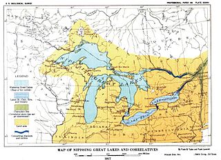
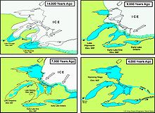
Nipissing Great Lakes was a prehistoric proglacial lake. Parts of the former lake are now Lake Superior, Lake Huron, Georgian Bay and Lake Michigan. It formed about 7,500 years before present (YBP). The lake occupied the depression left by the Labradorian Glacier. This body of water drained eastward from Georgian Bay to the Ottawa valley. This was a period of isostatic rebound raising the outlet over time, until it opened the outlet through the St. Clair valley.

<span class="mw-page-title-main">Lake Whittlesey</span>

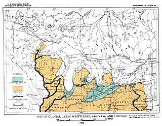
Lake Whittlesey was a proglacial lake that was an ancestor of present-day Lake Erie. It formed about 14,000 years ago. As the Erie Lobe of the Wisconsin Glacier retreated at the end of the last ice age, it left melt-water in a previously-existing depression area that was the valley of an eastward-flowing river known as the Erigan River that probably emptied into the Atlantic Ocean following the route of today's Saint Lawrence River. The lake stood at 735 feet (224 m) to 740 feet (230 m) above sea level. The remanent beach is not horizontal as there is a ‘hinge line’ southwest of a line from Ashtabula, Ohio, through the middle part of Lake St. Clair. The hinge line is where the horizontal beaches of the lake have been warped upwards towards the north by the isostatic rebound as the weight of the ice sheet was removed from the land. The rise is 60 feet (18 m) north into Michigan and the Ubly outlet. The current altitude of the outlet is 800 feet (240 m) above sea level. Where the outlet entered the Second Lake Saginaw at Cass City the elevation is 740 feet (230 m) above sea level. The Lake Whittlesey beach called the Belmore Beach and is a gravel ridge 10 feet (3.0 m) to 15 feet (4.6 m) high and one-eighth mile wide. Lake Whittlesey was maintained at the level of the Ubly outlet only until the ice melted back on the "Thumb" far enough to open a lower outlet. This ice recession went far enough to allow the lake to drop about 20 feet (6.1 m) below the lowest of the Arkona beaches to Lake Warren levels.

<span class="mw-page-title-main">Lake Arkona</span> Lake in Canada

Lake Arkona was a stage of the lake waters in the Huron-Erie-Ontario basin following the end of the Lake Maumee levels and before the Lake Whittlesey stages, named for Arkona, Ontario, about 50 miles (80 km) east of Sarnia.

<span class="mw-page-title-main">Lake Warren</span> Former proglacial lake in North America

Lake Warren was a proglacial lake that formed in the Lake Erie basin around 12,700 years before present (YBP) when Lake Whittlesey dropped in elevation. Lake Warren is divided into three stages: Warren I 690 feet (210 m), Warren II 680 feet (210 m), and Warren III 675 feet (206 m), each defined by the relative elevation above sea level.

Lake Wayne formed in the Lake Erie and Lake St. Clair basins around 12,500 years before present (YBP) when Lake Arkona dropped in elevation. About 20 feet (6.1 m) below the Lake Warren beaches it was early described as a lower Lake Warren level. Based on work in Wayne County, near the village of Wayne evidence was found that Lake Wayne succeeded Lake Whittlesey and preceded Lake Warren. From the Saginaw Basin the lake did not discharge water through Grand River but eastward along the edge of the ice sheet to Syracuse, New York, thence into the Mohawk valley. This shift in outlets warranted a separate from Lake Warren. The Wayne beach lies but a short distance inside the limits of the Warren beach. Its character is not greatly different when taken throughout its length in Michigan, Ohio, Pennsylvania and New York. At the type locality in Wayne County, Michigan, it is a sandy ridge, but farther north, and to the east through Ohio it is gravel. The results of the isostatic rebound area similar to the Lake Warren beaches.

<span class="mw-page-title-main">Saint Lawrence River Divide</span> Hydrological divide in eastern North America

The Saint Lawrence River Divide is a continental divide in central and eastern North America that separates the Great Lakes-St. Lawrence River Basin from the southerly Atlantic Ocean watersheds. Water, including rainfall and snowfall, lakes, rivers and streams, north and west of the divide, drains into the Gulf of St. Lawrence or the Labrador Sea; water south and east of the divide drains into the Atlantic Ocean or Gulf of Mexico. The divide is one of six continental divides in North America that demarcate several watersheds that flow to different gulfs, seas or oceans.

<span class="mw-page-title-main">Portage Escarpment</span>

The Portage Escarpment is a major landform in the U.S. states of Ohio, Pennsylvania, and New York which marks the boundary between the Till Plains to the north and west and the Appalachian Plateau to the east and south. The escarpment is the defining geological feature of New York's Finger Lakes region. Its proximity to Lake Erie creates a narrow but easily traveled route between upstate New York and the Midwest. Extensive industrial and residential development occurred along this route.

<span class="mw-page-title-main">Euclid Creek</span> River in Ohio, United States

Euclid Creek is a 43-mile (69 km) long stream located in Cuyahoga and Lake counties in the state of Ohio in the United States. The 11.5-mile (18.5 km) long main branch runs from the Euclid Creek Reservation of the Cleveland Metroparks to Lake Erie. The west branch is usually considered part of the main branch, and extends another 16 miles (26 km) to the creek's headwaters in Beachwood, Ohio. The east branch runs for 19 miles (31 km) and has headwaters in Willoughby Hills, Ohio.

References

Notes
  1. The Wisconsin glaciation is primarily responsible for the drainage patterns in Ohio. At first, the glaciers extended southward across most of Ohio. As they retreated, water shed from the glaciers carved channels southward to the Ohio River. When the glaciers retreated beyond the Portage Escarpment, water was trapped between the glaciers and the Portage Escarpment, creating ever-larger lakes. As the glaciers retreated northward again, the water found an outlet through the St. Lawrence River, carving new drainage valleys through the lake-facing side of the escarpment and the Erie Plain. [28]
Citations
  1. 1 2 3 Barnes & Wagner 2004, p. 372.
  2. 1 2 New York State Department of Transportation 1983, p. 22.
  3. 1 2 Cushing, Leverett & Van Horn 1931, p. 4.
  4. Wilder, Maynadier & Shaw 1911, pp. 200–201.
  5. Cushing, Leverett & Van Horn 1931, pp. 5–6, 34.
  6. Cushing, Leverett & Van Horn 1931, p. 5.
  7. Cushing, Leverett & Van Horn 1931, pp. 5–6.
  8. Hubbard et al. 1915, p. 13.
  9. 1 2 Cushing, Leverett & Van Horn 1931, pp. 2–3.
  10. 1 2 3 4 5 Cushing, Leverett & Van Horn 1931, p. 3.
  11. 1 2 3 Cushing, Leverett & Van Horn 1931, p. 14.
  12. New York State Air Pollution Control Board 1961, p. 58.
  13. Cushing, Leverett & Van Horn 1931, pp. 3, 14.
  14. 1 2 Wilder, Maynadier & Shaw 1911, p. 200.
  15. Tesmer & Bastedo 1981, p. 7.
  16. Cushing, Leverett & Van Horn 1931, pp. 13–14.
  17. 1 2 3 4 5 6 7 8 Waller 1921, p. 48.
  18. 1 2 Cushing, Leverett & Van Horn 1931, p. 10.
  19. Hubbard et al. 1915, pp. 10–11.
  20. 1 2 3 Cushing, Leverett & Van Horn 1931, p. 15.
  21. 1 2 Hubbard et al. 1915, p. 9.
  22. Jackson 1997, p. 7.
  23. Cushing, Leverett & Van Horn 1931, p. 18.
  24. Jackson 1997, p. 227.
  25. 1 2 Whitney 1994, p. 154.
  26. Whitney 1994, pp. 154–155.
  27. 1 2 Hasenstab 2007, p. 169.
  28. Hubbard et al. 1915, pp. 18–19.
  29. Hubbard et al. 1915, p. 11.
  30. Cushing, Leverett & Van Horn 1931, pp. 20–21.
  31. U.S. Environmental Protection Agency (March 9, 2006). "Great Lakes Factsheet No. 1" (PDF). National Research Council. Retrieved July 4, 2015.
  32. Waller 1921, p. 52.
  33. Waller 1921, p. 55.
  34. Barnes & Wagner 2004, p. 379.
  35. New York State Air Pollution Control Board 1961, p. 59.

Bibliography