Ferriday, Louisiana | |
---|---|
Coordinates: 31°37′50″N91°33′24″W / 31.63056°N 91.55667°W | |
Country | United States |
State | Louisiana |
Parish | Concordia |
Government | |
• Mayor | Sherrie Jacobs |
Area | |
• Total | 1.63 sq mi (4.22 km2) |
• Land | 1.63 sq mi (4.22 km2) |
• Water | 0.00 sq mi (0.00 km2) |
Elevation | 52 ft (16 m) |
Population (2020) | |
• Total | 3,189 |
• Density | 1,957.64/sq mi (755.74/km2) |
Time zone | UTC-6 (CST) |
• Summer (DST) | UTC-5 (CDT) |
ZIP codes | 71334 |
Area code | 318 |
FIPS code | 22-25440 |
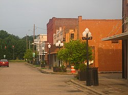
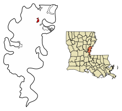
Ferriday is a town in Concordia Parish, which borders the Mississippi River and is located on the central eastern border of Louisiana, United States. With a population of 3,511 at the 2010 census, [2] it is an African-American majority town.
The town claims to have produced more famous people per square mile than any other in America. Elaine Dundy explored both celebrities and townsfolk in her book, Ferriday, Louisiana, published by E. P. Dutton in 1991. [3]
Churches of several major denominations are located here, including a large Pentecostal congregation south of town on Louisiana Highway 15, as well as Baptist, Assembly of God, Presbyterian, Methodist, and Catholic.
Ferriday is situated on the west side of Lake Concordia and 8 miles (13 km) from Lake St. John, oxbow lakes noted for recreational and professional bass fishing.
U.S. Routes 84 and 425 pass through the center of Ferriday. US 84 leads west 16 miles (26 km) to Jonesville, and US 425 leads north 6 miles (10 km) to Clayton. The two highways jointly lead southeast 11 miles (18 km) to Natchez, Mississippi.
According to the United States Census Bureau, Ferriday has a total area of 1.6 square miles (4.2 km2), all being land. [2]
Climate data for Ferriday, Louisiana | |||||||||||||
---|---|---|---|---|---|---|---|---|---|---|---|---|---|
Month | Jan | Feb | Mar | Apr | May | Jun | Jul | Aug | Sep | Oct | Nov | Dec | Year |
Record high °F (°C) | 83 (28) | 85 (29) | 91 (33) | 92 (33) | 99 (37) | 102 (39) | 102 (39) | 105 (41) | 103 (39) | 98 (37) | 87 (31) | 83 (28) | 105 (41) |
Mean daily maximum °F (°C) | 57 (14) | 63 (17) | 70 (21) | 77 (25) | 83 (28) | 89 (32) | 92 (33) | 91 (33) | 88 (31) | 79 (26) | 68 (20) | 59 (15) | 76 (24) |
Mean daily minimum °F (°C) | 39 (4) | 41 (5) | 49 (9) | 55 (13) | 63 (17) | 69 (21) | 72 (22) | 71 (22) | 66 (19) | 55 (13) | 48 (9) | 41 (5) | 56 (13) |
Record low °F (°C) | 4 (−16) | 8 (−13) | 18 (−8) | 28 (−2) | 30 (−1) | 49 (9) | 55 (13) | 50 (10) | 40 (4) | 27 (−3) | 18 (−8) | 5 (−15) | 4 (−16) |
Average precipitation inches (mm) | 6.44 (164) | 5.03 (128) | 6.74 (171) | 6.07 (154) | 5.49 (139) | 4.68 (119) | 4.03 (102) | 3.89 (99) | 3.73 (95) | 3.97 (101) | 5.58 (142) | 6.44 (164) | 62.09 (1,578) |
Average snowfall inches (cm) | 0.7 (1.8) | 0.2 (0.51) | 0.1 (0.25) | 0 (0) | 0 (0) | 0 (0) | 0 (0) | 0 (0) | 0 (0) | 0 (0) | 0 (0) | 0 (0) | 1 (2.56) |
Source: [4] |
Census | Pop. | Note | %± |
---|---|---|---|
1910 | 577 | — | |
1920 | 1,044 | 80.9% | |
1930 | 2,502 | 139.7% | |
1940 | 2,857 | 14.2% | |
1950 | 3,847 | 34.7% | |
1960 | 4,563 | 18.6% | |
1970 | 5,239 | 14.8% | |
1980 | 4,472 | −14.6% | |
1990 | 4,111 | −8.1% | |
2000 | 3,723 | −9.4% | |
2010 | 3,511 | −5.7% | |
2020 | 3,189 | −9.2% | |
U.S. Decennial Census [5] |
Race | Number | Percentage |
---|---|---|
White (non-Hispanic) | 362 | 11.35% |
Black or African American (non-Hispanic) | 2,704 | 84.79% |
Native American | 10 | 0.31% |
Asian | 7 | 0.22% |
Other/Mixed | 55 | 1.72% |
Hispanic or Latino | 51 | 1.6% |
As of the 2020 United States census, there were 3,189 people, 1,354 households, and 885 families residing in the town.
As of the census [7] of 2000, there were 3,723 people, 1,350 households, and 918 families residing in the town. The population density was 2,220.7 inhabitants per square mile (857.4/km2). There were 1,498 housing units at an average density of 893.5 per square mile (345.0/km2). The racial makeup of the town was 74.89% African American, 24.09% White, 0.19% Native American, 0.27% Asian, 0.03% Pacific Islander, 0.19% from other races, and 0.35% from two or more races. Hispanic or Latino of any race were 0.46% of the population.
There were 1,350 households, out of which 34.0% had children under the age of 18 living with them, 30.7% were married couples living together, 33.8% had a female householder with no husband present, and 32.0% were non-families. 29.3% of all households were made up of individuals, and 13.4% had someone living alone who was 65 years of age or older. The average household size was 2.62 and the average family size was 3.27.
In the town, the population was spread out, with 32.0% under the age of 18, 9.6% from 18 to 24, 22.2% from 25 to 44, 18.6% from 45 to 64, and 17.5% who were 65 years of age or older. The median age was 34 years. For every 100 females, there were 76.2 males. For every 100 females age 18 and over, there were 68.2 males.
The median income for a household in the town was $14,732, and the median income for a family was $18,636. Males had a median income of $23,654 versus $16,725 for females. The per capita income for the town was $8,767. About 40.7% of families and 47.4% of the population were below the poverty line, including 70.2% of those under age 18 and 25.1% of those age 65 or over.
In 2010, Ferriday had the 15th-lowest median household income of all places in the United States with a population over 1,000. [8]
The Concordia Parish School Board serves Ferriday. Ferriday High School is located off LA 15. Its sports teams are known as the Trojans. To the right rear of the high school is the Concordia Parish Library.
Central Louisiana Technical Community College has a campus located in Ferriday.
Concordia Parish is a parish that borders the Mississippi River in eastern central Louisiana. As of the 2020 census, the population was 18,687. The parish seat is Vidalia. The parish was formed in 1807.
Oakdale is a city in Allen Parish in south Louisiana, United States. The population was 7,780 at the 2010 census.
Oberlin is a town in and the parish seat of Allen Parish, Louisiana, United States. The population was 1,770 at the 2010 census. The town is named after Johann Friedrich Oberlin.
Evergreen is a town in Avoyelles Parish, Louisiana, United States. The population was 310 at the 2010 census. Evergreen is located east of Bunkie.
Harrisonburg is a village in and the parish seat of Catahoula Parish, Louisiana, United States. The population was 348 as of the 2010 census, down from 746 in 2000.
Jonesville is the largest town in Catahoula Parish, Louisiana, United States, at the confluence of the Ouachita, Tensas, and Little rivers. The three rivers become the Black River at Jonesville.
Clayton is a town in northern Concordia Parish, Louisiana, United States. The population was 711 at the 2010 census. Cotton is a principal commodity in the area. Clayton is located on the Tensas River, important for fishing and boating, promoted through a U.S. Army Corps of Engineers-maintained boat launch. The Tensas River merges with the Black River in Jonesville in Catahoula Parish.
Ridgecrest is a small town in Concordia Parish, Louisiana, United States. The population was 694 at the 2010 census.
Vidalia is the largest city and the parish seat of Concordia Parish, Louisiana, United States. The population was 4,299 as of the 2010 census.
West Ferriday is an Unincorporated Community and former census-designated place (CDP) in Concordia Parish, Louisiana, United States. The population was 1,541 at the 2000 census. The area was not delineated as a CDP for the 2010 or the 2020 census.
Clinton is a town in, and the parish seat of, East Feliciana Parish, Louisiana, United States. The town was named for New York Governor DeWitt Clinton. The population was 1,653 at the 2010 census. It is part of the Baton Rouge Metropolitan Statistical Area.
Jackson is a town in East Feliciana Parish, Louisiana, United States. The population was 3,842 at the 2010 U.S. census, down from 4,130 in 2000; the 2020 population estimates program determined Jackson had a population of 3,707. It is part of the Baton Rouge metropolitan statistical area.
Slaughter is a town in East Feliciana Parish, Louisiana, United States. The population was 997 at the 2010 U.S. census, down from 1,011 at the 2000 U.S. census. In the 2020 population estimates program, the U.S. Census Bureau estimated that 882 people lived in the township. Slaughter is part of the Baton Rouge metropolitan statistical area.
Mangham is a village in Richland Parish in northeastern Louisiana, United States. The population was 672 at the 2010 census. Mangham was established in 1890. It is named for Wiley P. Mangham, the publisher of the Richland Beacon-News, a weekly newspaper in Rayville, the seat of Richland Parish.
Lutcher is a town in St. James Parish, Louisiana, United States, on the east bank of the Mississippi River. It is part of the New Orleans Metropolitan Area. The population was 3,559 at the 2010 U.S. census, and 3,127 at the 2020 population estimates program.
Baldwin is a town in St. Mary Parish, Louisiana, United States. The population was 2,436 at the 2010 census, down from 2,497 in 2000. It is part of the Morgan City Micropolitan Statistical Area. Its population is majority African American. The town has been home to educational institutions for white and "colored" students.
Berwick is a town in St. Mary Parish, Louisiana, United States. The population was 4,946 at the 2010 census. It is part of the Morgan City Micropolitan Statistical Area.
Roseland is a town in Tangipahoa Parish, Louisiana, United States. The population was 1,123 at the 2010 census. It is the birthplace of Cajun chef and storyteller Justin Wilson.
Basile is a town in Acadia and Evangeline parishes in the U.S. state of Louisiana. The population was 1,214 in 2020.
The Natchez Micropolitan Statistical Area is a micropolitan area that consists of Adams County, Mississippi and Concordia Parish, Louisiana. As of the 2000 census, it had a population of 54,587.