Minnesota is a state in the upper Midwestern United States. It is the 12th largest U.S. state in area and the 22nd most populous, with over 5.7 million residents. Minnesota's geography consists of western prairies, now given over to intensive agriculture; deciduous forests in the southeast, now partially cleared, farmed, and settled; and the less populated North Woods, used for mining, forestry, and recreation. Roughly a third of the state is covered in forests, and it is known as the "Land of 10,000 Lakes" for having over 14,000 bodies of fresh water of at least ten acres. A little more than half of Minnesotans live in the Minneapolis–Saint Paul metropolitan area, known as the "Twin Cities", the state's main political, economic, and cultural hub. The Twin Cities is the 16th largest metropolitan area in the U.S. Other Minnesota minor metropolitan and micropolitan statistical areas include Duluth, Mankato, Moorhead, Rochester, and St. Cloud.

Saint Paul is the capital of the U.S. state of Minnesota and the county seat of Ramsey County. Historically a major railroad and commercial center for the Upper Midwest, the decline of those industries in the last half of the 20th century has changed the local economy and cultural identity of the city. One of the oldest cities in Minnesota, Saint Paul is a grouping of urban villages and historic neighborhoods along the Mississippi River.

Hennepin County is a county in the U.S. state of Minnesota. Its county seat is Minneapolis, the state's most populous city. The county is named in honor of the 17th-century explorer Father Louis Hennepin. The county's eastern side is influenced by Minneapolis with its financial and manufacturing activity. The western side of the county is mostly suburbs and rural communities, along with some farms, covered with extensive woods, hills, and lakes.

Dakota County is the third-most populous county in the U.S. state of Minnesota, located in the east central portion of the state. As of the 2020 United States Census, the population was 439,882. The county seat is Hastings. Dakota County is named for the Dakota Sioux tribal bands who inhabited the area. The name is recorded as "Dahkotah" in the United States Census records until 1851. Dakota County is included in the Minneapolis–St. Paul–Bloomington, MN–WI Metropolitan Statistical Area, the sixteenth largest metropolitan area in the United States with about 3.64 million residents. The largest city in Dakota County is the city of Lakeville, the eleventh-largest city in Minnesota and sixth-largest Twin Cities suburb. The county is bordered by the Minnesota and Mississippi Rivers on the north, and the state of Wisconsin on the east.

Minneapolis–Saint Paul is a metropolitan area built around the confluence of the Mississippi, Minnesota and St. Croix rivers in Minnesota. The area, historically a major railroad and flour milling center, is commonly known as the Twin Cities after its two largest cities, Minneapolis, the most populous city in the state, and Saint Paul, the state capital, which directly borders Minneapolis to the east. It is an example of twin cities in the sense of geographical proximity. Minnesotans often refer to the two together simply as "the Cities".

Minnetonka is a suburban city in Hennepin County, Minnesota, United States, about 9 miles (14 km) west of Minneapolis. The name comes from the Dakota Sioux mni tanka, meaning "great water". U.S. Highway 12 is the city’s main road.

Richfield is a city in Hennepin County, Minnesota, United States. An inner-ring suburb of the Minneapolis–Saint Paul region, it is bordered by Minneapolis to the north, Minneapolis–Saint Paul International Airport to the east, Bloomington to the south, and Edina to the west. Best Buy, the U.S.'s largest electronics retailer, has its headquarters in Richfield. The population was 36,994 at the 2020 census.

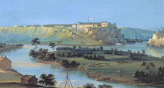
Fort Snelling is a former military fortification and National Historic Landmark in the U.S. state of Minnesota on the bluffs overlooking the confluence of the Minnesota and Mississippi rivers. The military site was initially named Fort Saint Anthony, but it was renamed Fort Snelling once its construction was completed in 1825.

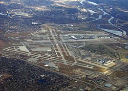
Minneapolis–Saint Paul International Airport, also less commonly known as Wold-Chamberlain Field, is a joint civil-military public use international airport. It is located in Fort Snelling Unorganized Territory, Minnesota, United States. Centrally located within 10 miles of both downtown Minneapolis and downtown Saint Paul, MSP is the busiest airport in the Upper Midwest.

The Territory of Minnesota was an organized incorporated territory of the United States that existed from March 3, 1849, until May 11, 1858, when the eastern portion of the territory was admitted to the Union as the State of Minnesota.

The history of the U.S. state of Minnesota is shaped by its original Native American residents, European exploration and settlement, and the emergence of industries made possible by the state's natural resources. Minnesota achieved prominence through fur trading, logging, and farming, and later through railroads, and iron mining. While those industries remain important, the state's economy is now driven by banking, computers, and health care.

The Archdiocese of Saint Paul and Minneapolis is a Latin Church ecclesiastical jurisdiction or diocese of the Catholic Church in the United States. It is led by an archbishop who administers the archdiocese from the cities of Saint Paul and Minneapolis. The archbishop has both a cathedral and co-cathedral: the mother church, the Cathedral of Saint Paul in Saint Paul and the co-cathedral, the Basilica of Saint Mary in Minneapolis.

The Mendota Bridge, Minnesota, United States, carries State Highways 55 and 62 over the Minnesota River between Fort Snelling and Mendota Heights. It is the final bridge over the Minnesota River before the Minnesota flows into the Mississippi River at the "Meeting of the waters" or "Mendota" in the Dakota language. Traffic on the north end of the bridge may turn onto the Fort Road Bridge to cross the Mississippi River into Saint Paul, Minnesota. The skylines of both Minneapolis and Saint Paul can be seen simultaneously from the bridge.

Compass Airlines, LLC was an American regional airline headquartered in Delta Air Lines Building C at Minneapolis−Saint Paul International Airport in Fort Snelling, Hennepin County, Minnesota; prior to December 16, 2009, it was headquartered in unincorporated Fairfax County, Virginia, United States, east of the Chantilly CDP. The airline launched inaugural service with a single Bombardier CRJ-200 aircraft under the Northwest Airlink brand between Minneapolis/St. Paul and Washington, D.C. on May 2, 2007. On August 21, 2007, it began flying two Embraer E175 76-passenger aircraft, and expanded to 36 aircraft by December 2008.

Fort Snelling National Cemetery is a United States National Cemetery located in the Fort Snelling Unorganized Territory adjacent to the historic fort and Minneapolis–Saint Paul International Airport. It is one of the two national cemeteries in the state and is the older. Administered by the United States Department of Veterans Affairs, it covers 436.3 acres (176.6 ha), and as of 2021 had over 246,000 interments. It was listed on the National Register of Historic Places in 2016.
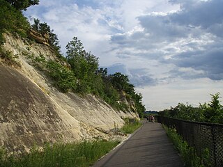
Big Rivers Regional Trail is a paved 4.5-mile (7.2 km) rail trail that overlooks the confluence of the Minnesota and Mississippi rivers along the northern edge of Dakota County, Minnesota, United States. It runs between the cities of Eagan and Lilydale.

Republic Airlines was a United States airline formed by the merger of North Central Airlines and Southern Airways on July 1, 1979. Their headquarters were at Minneapolis-St. Paul International Airport, in what is now Fort Snelling in unincorporated Hennepin County, Minnesota. The former headquarters is now Delta Air Lines Building C. Republic was acquired by and merged into Northwest Airlines in 1986.
Minnesota State Highway 62 (MN 62) is a highway in the Twin Cities region of Minnesota. The route was part of County Road 62 (CR 62) until 1988, when a portion of the route was inherited by the state. The western terminus of the highway is at Interstate 494 (I-494) in Eden Prairie, where the roadway continues west as CR 62 to CR 101. The eastern terminus of the route is at the junction with I-494 in Inver Grove Heights. Locally, the original portion of the route in Hennepin County is known as "the Crosstown," though signage with this name does not appear on the highway itself, but only on local streets adjacent to the road. It is also used as an alternate name, even by the Minnesota Department of Transportation (MnDOT). The route is 18.6 miles (29.9 km) in length.
The following outline is provided as an overview of and topical guide to the U.S. state of Minnesota:
The territorial era of Minnesota lasted from the Louisiana Purchase in 1803 to Minnesota's achieving statehood in 1858. The Minnesota Territory itself was formed only in 1849 but the area had a rich history well before this. Though there was a long history of European presence in the area before 19th century, it was during the 19th century that the United States began to establish a firm presence in what would become Minnesota.