
San Diego is a city in the U.S. state of California on the coast of the Pacific Ocean, approximately 110 miles (180 km) southeast of downtown Los Angeles and immediately adjacent to the border with Mexico. With an estimated population of 1,423,851 as of July 1, 2019, San Diego is the eighth most populous city in the United States and second most populous in California. The city is the county seat of San Diego County, the fifth most populous county in the United States, with 3,338,330 estimated residents as of 2019. San Diego is part of the San Diego–Tijuana conurbation, the second-largest transborder agglomeration between the U.S. and a bordering country, home to an estimated 4,922,723 people as of 2012. The city is known for its mild year-round climate, natural deep-water harbor, extensive beaches, long association with the United States Navy and Marine Corps, and recent emergence as a healthcare and biotechnology development center.

Ramona is a census-designated place (CDP) in San Diego County, California. The population was 20,292 at the 2010 census.

San Diego Country Estates, commonly referred to as the Estates, is a valley resort populace composed of several neighborhoods associated with the unincorporated community of Ramona, California. The Estates are a census-designated place in North County, a region of the San Diego metropolitan area. The Estates is just east of the North County city of Poway and southeast of Ramona; 38 miles (61 km) northeast of San Diego and 46 miles (74 km) from the regional center of Carlsbad. San Diego Country Estates had a population of 10,109 at the 2010 census, up from 9,262 at the 2000 census.
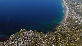
La Jolla is a hilly, seaside neighborhood within the city of San Diego, California, occupying 7 miles (11 km) of curving coastline along the Pacific Ocean within the northern city limits. The population reported in the 2010 census was 46,781.
Four Corners is a region in the southwestern United States where the corners of Colorado, Utah, New Mexico and Arizona meet.

North County is a region in the northern area of San Diego County, California. It is the second-most populous region in the county, with an estimated population of 869,322. North County is well known for its affluence, especially in Encinitas, Carlsbad, Del Mar, Rancho Santa Fe, and Solana Beach, where house prices range, on average, above $1,000,000. Cities along the 78 freeway have more mixed incomes. Places such as south Oceanside, far north Oceanside, east Vista, south Vista, north San Marcos, the San Elijo Hills region of San Marcos, and far west Escondido are typically affluent as well. Homes prices throughout the region range from around $550,000 to $25,000,000.
Southwestern College is a public community college in Chula Vista, California. Founded in 1961, Southwestern College serves approximately 19,000 students annually.

Campo is an unincorporated community in the Mountain Empire area of southeastern San Diego County, California, United States. The population was 2,684 at the 2010 census. For statistical purposes, the United States Census Bureau has defined Campo as a census-designated place (CDP). The census definition of the area may not precisely correspond to local understanding of the area with the same name.

Charles F. O'Neall was a real estate agent and an American Democratic politician from California.

University Heights is a neighborhood in Central San Diego, California centered on Park Boulevard and Adams Avenue. According to the City of San Diego Assessor/Recorder/County Clerk parcel maps, University Heights is bounded on the west and north by the edge of the mesa, the southern boundary is Lincoln Avenue, and the eastern boundary is Boundary Street along the western edge of Interstate 805. The area is filled with a number of restaurants, coffee shops, boutiques, and artist studios primarily on Park Boulevard and Adams Avenue. Live entertainment can be found most nights. Adjacent to Hillcrest, Normal Heights and North Park, additional restaurants, bars, coffee shops, and night clubs are within easy reach.

University City (UC) is a community in San Diego, California, located in the northwestern portion of the city next to the University of California, San Diego. University City is bordered by La Jolla and Interstate 5 to the west, Miramar and Interstate 805 to the east, and North Clairemont and Highway 52 to the south, giving the community a triangular-shaped boundary. University City is a part of District 1, which is represented by Councilmember Barbara Bry on the San Diego City Council.

San Diego County, officially the County of San Diego, is a county in the southwestern corner of the state of California, in the United States. As of the 2010 census, the population was 3,095,313, making it California's second-most populous county and the fifth-most populous in the United States. Its county seat is San Diego, the second-most populous city in California and the eighth-most populous city in the United States. It is the southwesternmost county in the 48 contiguous United States, and is a border county.

The Barona Group of Capitan Grande Band of Mission Indians of the Barona Reservation is a federally recognized tribe of Kumeyaay Indians, who are sometimes known as Mission Indians.

The Wooded Area is a neighborhood within the community of Point Loma, San Diego, California. It encompasses the hilltop area south of Talbot Street on both sides of Catalina Boulevard; the area west of Catalina is also referred to as the College Area. The Wooded Area borders Naval Base Point Loma to the south, La Playa to the east, Roseville-Fleetridge to the north, and Sunset Cliffs and Point Loma Nazarene University to the west. The boundaries of the neighborhood are not universally agreed upon, with different maps showing different borders.

East County is a region of San Diego County, California east of San Diego.
The Regions of the San Diego metropolitan area and San Diego County, as they cover the same area are:

Lincoln Park is an urban community in the southeastern section of San Diego, California. It is bordered by Chollas View and the San Diego Trolley on the north, Mountain View and Interstate 805 on the west, Valencia Park and Euclid Avenue on the east, and National City, California on the south. Major thoroughfares include Imperial Avenue, Ocean View Boulevard, and Logan Avenue.

Municipal elections were held in San Diego in 2012 for mayor, city attorney, five seats to the San Diego City Council, and propositions. The primary election was held on June 5, 2012, and the general election was held on November 6, 2012. This was the first city council election to use nine council districts. Two city council incumbents ran for reelection in their same district and one ran for election in the newly created ninth district.
Municipal elections were held in San Diego in 2020 for mayor, city attorney, and city council. The primary election occurred Tuesday, March 3, 2020, and the general election occurred Tuesday, November 3, 2020. Five of the nine council seats were contested. No council incumbents stood for reelection.
