Buildings, sites, districts, and objects in California listed on the National Register of Historic Places:

James Barney Marsh was an American engineer and bridge designer. He patented a new design for arch bridges. Marsh gave Archie Alexander, the first African-American to graduate as an engineer from Iowa State University, his first job. Marsh worked in the bridge building business for over 50 years, and several of his bridges are listed in the National Register of Historic Places.

The Tower Bridge is a vertical lift bridge across the Sacramento River, linking West Sacramento in Yolo County to the west, with the capital of California, Sacramento, in Sacramento County to the east. It has also been known as M Street Bridge. It was previously a part of U.S. Route 40 until that highway was truncated to east of Salt Lake City as well as US Route 99W, which served the western portion of the Sacramento Valley from Sacramento to Red Bluff. The bridge is maintained by the California Department of Transportation as part of State Route 275 and connects West Capitol Avenue and Tower Bridge Gateway in West Sacramento with the Capitol Mall in Sacramento.

Honey Run Covered Bridge was a wooden covered bridge crossing Butte Creek, in Butte County, northern California in the United States. It was located on Honey Run Road at Centerville Road, about halfway in between Chico and Paradise, until it was destroyed in the Camp Fire on November 8, 2018.

The Bridgeport Covered Bridge is located in Bridgeport, Nevada County, California, southwest of French Corral and north of Lake Wildwood. It is used as a pedestrian crossing over the South Yuba River. The bridge was built in 1862 by David John Wood. Its lumber came from Plum Valley in Sierra County, California. The bridge was closed to vehicular traffic in 1972 and pedestrian traffic in 2011 due to deferred maintenance and "structural problems".
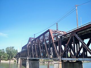
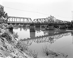
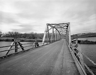
The I Street Bridge is a historic metal truss swing bridge which crosses the Sacramento River to link the capital city of Sacramento, California, with Yolo County to the west. Built in 1911, this historic bridge has a vertical clearance of 14 feet 8 inches (4.47 m) and was originally part of State Route 16. It also carries two walkways; one on either side of the roadway.

The Generals' Highway Stone Bridges, built in 1930, are part of the Generals' Highway from the General Grant Grove of giant sequoias in Kings Canyon National Park through Sequoia National Park. One bridge spans the Marble Fork of the Kaweah River in a wooded setting, while the other, similar bridge spans Clover Creek in a bare canyon.

The St. Francis River Bridge carries United States Route 70 over the St. Francis River near Madison in St. Francis County, Arkansas, United States. It consists of three Parker through trusses, each 162 feet (49 m) long, and a swing bridge span 230 feet (70 m) long. With approaches, the bridge has a total length of 921 feet (281 m). The swing span is mounted on a central pier, and is rotated by two workers operating a large hickory handle. The bridge was built in 1932–33, with the swing span design made to accommodate the demands of the United States War Department that the river remain navigable by military vessels. The bridge is one of three swing-span bridges in the state. It is likely that the swinging mechanism has never been used.

The Saugatuck River Bridge is a bridge in Connecticut carrying Route 136 over the Saugatuck River in Westport. The bridge, built in 1884, is the oldest surviving movable bridge in Connecticut and is listed on the National Register of Historic Places. The total length of the bridge is 87.5 metres (287 ft) with a deck width of 6.1 metres (20 ft) and a minimum vertical clearance of 2.1 metres (6.9 ft) above the river. The bridge carries an average of about 16,000 vehicles per day. In 2007, the bridge was named the William F. Cribari Memorial Bridge.

John Buck Leonard (1864–1945) was a pioneering bridge engineer and architect, early advocate for reinforced concrete, working mainly in northern California.

The Pengra Pass rail route, also known as the Natron Cutoff, the Cascade Subdivision, or the Cascade Line, is a Union Pacific Railroad line connecting Eugene, Oregon, with Klamath Falls, Oregon. Construction of the line began in 1905 and was completed in the mid-1920s. Its name denotes a mountain pass on the Lane County–Klamath County boundary in the Cascade Mountains of Oregon, about 1.5 miles (2.4 km) from Willamette Pass. The line heads southeast from Eugene, up the Cascades and over Pengra Pass, then southward beside U.S. Route 97 to Klamath Falls, where it splits in two, each track continuing into California. The route has at least 22 tunnels, several snow sheds and multiple bridges across canyons.

The Yosemite Valley Bridges are eight bridges in the Yosemite Valley of Yosemite National Park, most of them spanning the Merced River. Five of them were built in 1928, with the remainder built between 1921 and 1933. The bridges feature a concrete structure faced with local stone, in an elliptical or three-centered arch configuration. They are notable for their uniform character and for their conformance to tenets of the National Park Service rustic style. Design work for the seven newer bridges was by George D. Whittle of the San Francisco District Office of the U.S. Bureau of Public Roads for the National Park Service. Concrete bridges were chosen at the urging of Thomas Chalmers Vint of the Park Service, in lieu of alternative designs for steel truss bridges, or suspension bridges suggested by the park superintendent.
The DFU Elk Mountain Bridge was a Warren pony truss bridge located near Elk Mountain, Wyoming, which carried Carbon County Road 120-1 over the Medicine Bow River. The bridge was built in 1823 by contractor D. B. Miller. While the bridge's design is mainly a Warren truss, the top chord of the bridge is reminiscent of a Parker truss. At 102 feet (31 m) long, the bridge is the longest of its design in the Wyoming county highway system.

The DMJ Pick Bridge is a Parker through truss bridge located near Saratoga, Wyoming, which carries Carbon County Road CN6-508 across the North Platte River. The bridge was built from 1909 to 1910 by contractor Charles G. Sheely; it was originally located south of Fort Steele. In 1934, the bridge was moved up the river to its current location, as a new bridge had been built at its original site five years earlier. The bridge is the only Parker truss bridge remaining in Wyoming, after the Arvada Bridge was replaced in 1990.
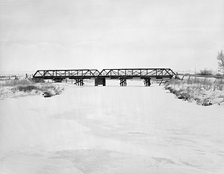
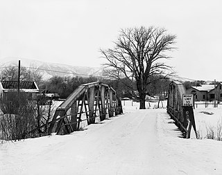
The DOE Bridge over Laramie River was a Pratt half-hip pony truss bridge located near Bosler, Wyoming, which carried Albany County Road CNA-740 across the Laramie River. The bridge was built in 1926 by contractor N. A. Swenson; it was originally part of the Lincoln Highway. In 1932, the bridge was replaced and moved to its current location. It was the last two-span Pratt half-hip truss bridge remaining in Wyoming.
The DUX Bessemer Bend Bridge was a Warren through truss bridge in Bessemer Bend, Wyoming, which carried Natrona County Road CN1-58 across the North Platte River. The bridge was built from 1921 to 1922. When nominated to the National Register of Historic Places in 1982, it was one of only three Warren through truss bridges remaining on Wyoming county highways. In addition, the bridge was located at the site of a historic river crossing on the Oregon Trail.

The St. Francis River Bridge, also known as the Lake City Bridge, was a historic bridge spanning the St. Francis River at Lake City, Arkansas. It was composed of 109 I-beam trestles and a single vertical lift span, and had a total length of 3,412 feet (1,040 m). The bridge was designed and built in 1934 by the Vincennes Bridge Company, and carried Arkansas Highway 18 until 1998, when a modern 4-span I-beam bridge was built adjacent to it. The old bridge was dismantled, leaving only the vertical lift segment on the east bank of the river.

Isleton Bridge is a historic bascule bridge carrying California State Route 160 across the Sacramento River north of Isleton, California, built in 1923. There are two concrete tied arch spans, each 102 feet (31 m) long, to the east of the main bascule span, which is 226 feet (69 m) long, and four concrete girder spans. The bridge was designed by Sacramento County engineer Charles W. Deterding, with the Strauss Bascule Bridge Company of Chicago designing the bascule span. Steel portions of the bridge were fabricated by the American Bridge Company and the bridge was constructed by Jenkins & Elton of Sacramento.

The Black River Bridge carries U.S. Route 67 (US 67) across the Black River in Pocahontas, Arkansas. The bridge is a twin span, each carrying two lanes of traffic. The northern bridge was a historic structure, built in 1934 by the Pittsburgh-Des Moines Steel Co., and was listed on the National Register of Historic Places. In 2016 demolition began on the northern bridge, and it was delisted in 2018. This bridge consisted of two Parker trusses, one on either side of a Warren swing span, and trestled approaches, giving it a total length of 1,255 feet (383 m). It was one of three surviving swing bridges in the state. The southern bridge is a modern steel girder structure, built in 1986, whose construction rendered the swing section inoperative.
The Petit Jean River Bridge is a historic bridge in rural southern Logan County, Arkansas. The bridge carries Old Highway 109 across the Petit Jean River between Sugar Grove and Magazine. It consists of a single-span steel Pratt through truss and two masonry approach spans, set on concrete piers in the river. The total structure length is 273 feet (83 m), with a roadway width of 19 feet (5.8 m) and a total width of 24 feet (7.3 m). The bridge was built in 1938.