
Ancaster is a historic town in the city of Hamilton, Ontario, Canada, located on the Niagara Escarpment. Founded as a town in 1793, it immediately developed itself into one of the first significant and influential early British Upper Canada communities established during the late 18th century eventually amalgamating with the city of Hamilton in 2001. By 1823, due to its accessible waterpower and location at the juncture of prehistoric indigenous trading routes, Ancaster had become Upper Canada's largest industrial and commercial centre. Additionally, Ancaster had at that time attracted the 2nd largest populace (1,681) in Upper Canada, trailing only Kingston, but surpassing the populations of nearby Toronto (1,376) and Hamilton (1,000). After this initial period of prosperity in the late 18th century, sudden significant water and rail transportation advancements of the early 19th century would soon better benefit Ancaster's neighbouring towns nearer the Lake Ontario waterfront. Stationary steam engines for industries rapidly developing in the 19th century would eventually make Ancaster's water-powered industries less vital. As a result, after the 1820s, Ancaster's influence would begin to wane during the remainder of the 19th century.

Ancaster—Dundas—Flamborough—Westdale was a federal electoral district in Ontario, Canada, that has been represented in the House of Commons of Canada from 2004 until the electoral boundaries were redrawn for the 2015 election.

Flamborough is a district and former municipality in the city of Hamilton, Ontario, Canada. For most of its existence before amalgamation with Hamilton in 2001, Flamborough comprised the former townships of East Flamborough, West Flamborough, and Beverly, as well as the village of Waterdown. The largest suburban community is the former village of Waterdown containing perhaps one third of its thirty thousand or so inhabitants. Other Flamborough communities include Carlisle, Christie's Corners, Clappison's Corners, Copetown, Freelton, Greensville, Lynden, Kirkwall, Millgrove, Mountsberg, Orkney, Peters Corners, Rockton, Troy, Sheffield, Valens, Strabane and Westover.

The Regional Municipality of Hamilton–Wentworth was an upper-tier regional municipality in Ontario, Canada, that existed between January 1, 1974, and January 1, 2001. It was composed of six municipalities, centered on and including the City of Hamilton, and existed to coordinate certain shared services, such as policing and public transit, for those municipalities. It was created through the restructuring of Wentworth County, and was one of the last such governments to be created in Ontario.

Stoney Creek is a community in the city of Hamilton in the Canadian province of Ontario. It was officially a city from 1984 to 2001, when it was amalgamated with Hamilton, Glanbrook, Ancaster, Dundas and Flamborough to form Hamilton.
Wentworth County, area 269,057 acres (1,089 km2), is a historic county in the Canadian province of Ontario.

Waterdown is a village in Canada which since 2001 has been a community of Hamilton, Ontario. Waterdown is approximately 60 km west of downtown Toronto. Waterdown, as of 2021, has a population of approximately 24,400 residents.

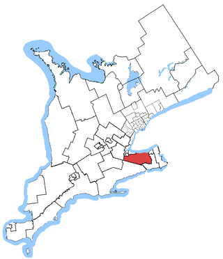
Hamilton Mountain is a federal electoral district in Ontario, Canada, that has been represented in the House of Commons of Canada since 1968. The riding is located in the Hamilton region.
Niagara West—Glanbrook was a federal electoral district in Ontario, Canada, that existed from 2004 to 2015.
Wentworth South was a federal electoral district represented in the House of Commons of Canada from 1867 to 1904. it was located near Hamilton in the province of Ontario.
Dynasty Communications was a publisher of three alternative weekly newspapers in Ontario, Canada. These publications served the Kitchener, Hamilton and Niagara areas.
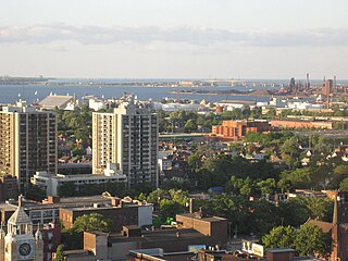
Hamilton is located on the western end of the Niagara Peninsula and wraps around the westernmost part of the Lake Ontario. Most of the city including the downtown section lies along the south shore. Situated in the geographic centre of the Golden Horseshoe, it lies roughly midway between Toronto and Buffalo. The two major physical features are Hamilton Harbour marking the northern limit of the city and the Niagara Escarpment running through the middle of the city across its entire breadth, bisecting the city into 'upper' and 'lower' parts.
Ancaster—Dundas—Flamborough—Aldershot was a provincial electoral district in southwestern Ontario, Canada, that elected one member of the Legislative Assembly of Ontario. It was created in 1999 from Wentworth North, Burlington South and Halton Centre. It was abolished in 2007 and redistributed into Ancaster—Dundas—Flamborough—Westdale, Burlington, Hamilton Centre, Hamilton Mountain and Niagara West—Glanbrook.

John Urwin Dickenson was a Hamilton, Ontario contractor and political figure. He represented Wentworth South in the Legislative Assembly of Ontario from 1896 to 1904 as a Liberal member.

Augustus Jones was a North American-born Upper Canadian farmer, land speculator, magistrate, militia captain and surveyor. Jones trained as a surveyor in New York City, and fled as a United Empire Loyalist to Upper Canada. In Upper Canada, he worked as a crown surveyor in the Nassau District, where he quickly rose to the position of Deputy Surveyor General, the highest position in a district of Upper Canada. He occupied that position from 1789 informally, and 1791 formally, until his retirement in 1799. During that time he laid down many of the township boundaries in the Niagara Peninsula and on the north shore of Lake Ontario. He led various teams that cut many of the first sideroads and concession roads into these areas, facilitating their settlement by European and American immigrants. Jones also surveyed the routes for Dundas Street and Yonge Street, and supervised their construction. After his retirement, Jones farmed first in Saltfleet Township, later moving to Brantford and finally an estate outside Paris named Cold Springs, where he died in 1836.

The flag of Hamilton was designed by Bishop Ralph Spence and granted to the city on July 15, 2003.

King Street starts off as a collector road in the east-end of town in Dundas, Hamilton, Ontario, Canada beside Cootes Paradise and the Desjardins Canal at Olympic Drive and switches to an arterial road at York Street and cuts through the town of Dundas where it ends in the west-end by the CN railway tracks at the base of the Niagara Escarpment. It is a two-way street throughout.

The 2000 Hamilton municipal election was a municipal election held on November 13, 2000, to elect municipal officials for the City of Hamilton. On election day, Hamiltonians elected a mayor, 15 city councillors, and trustees for the Hamilton-Wentworth District School Board, Hamilton-Wentworth Catholic District School Board, Conseil scolaire Viamonde, and Conseil scolaire catholique MonAvenir. This was the first election of the "New" City of Hamilton after the dissolution of the Region of Hamilton-Wentworth and the amalgamation of Dundas, Stoney Creek, Flamborough, Ancaster, Glanbrook, and Waterdown with the existing city of Hamilton.
The Hamilton Fire Department provides fire protection, technical rescue services, hazardous materials response, and first responder emergency medical assistance to the city of Hamilton, Ontario.

