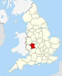
There are over 20,000 Grade II* listed buildings in England. This page is a list of these buildings in the Malvern Hills district in Worcestershire.
There are over 20,000 Grade II* listed buildings in England. This page is a list of these buildings in the Malvern Hills district in Worcestershire.
| Name | Location | Type | Completed [note 1] | Date designated | Grid ref. [note 2] Geo-coordinates | Entry number [note 3] | Image |
|---|---|---|---|---|---|---|---|
| Abberley Hall (that Part in Abberley) | Abberley Park, Abberley, Malvern Hills | House | Early 18th century | 18 June 1976 | SO7449666437 52°17′44″N2°22′31″W / 52.295463°N 2.375383°W | 1155526 |  |
| Church of St Michael | Abberley, Malvern Hills | Parish Church | 12th century | 29 July 1959 | SO7535067869 52°18′30″N2°21′47″W / 52.308376°N 2.362967°W | 1082704 |  |
| Clock Tower, to North of Abberley Hall | Abberley Park, Abberley, Malvern Hills | Clock Tower | 1883-84 | 18 June 1976 | SO7447166652 52°17′51″N2°22′33″W / 52.297395°N 2.375766°W | 1082707 |  |
| Church of St Mary Magdalene | Alfrick, Malvern Hills | Parish Church | Late 12th century | 29 July 1959 | SO7484552974 52°10′28″N2°22′09″W / 52.174445°N 2.369259°W | 1082221 |  |
| Pool House | Astley, Astley and Dunley, Malvern Hills | House | 17th century | 12 November 1951 | SO7959168393 52°18′48″N2°18′03″W / 52.313262°N 2.300796°W | 1082684 | 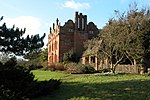 |
| Yarhampton House | Yarhampton, Astley and Dunley, Malvern Hills | Farmhouse | 1610 | 12 November 1951 | SO7761767392 52°18′15″N2°19′47″W / 52.304186°N 2.329685°W | 1082688 | 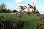 |
| Church of St Bartholomew | Bayton, Malvern Hills | Parish Church | 12th century | 18 April 1966 | SO6912373223 52°21′22″N2°27′17″W / 52.356192°N 2.45479°W | 1081471 |  |
| Shakenhurst | Bayton, Malvern Hills | Country House | 17th century | 18 April 1966 | SO6728272970 52°21′14″N2°28′54″W / 52.353811°N 2.481795°W | 1081469 | 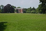 |
| Church of St Faith | Berrow, Malvern Hills | Church | 12th century | 23 March 1968 | SO7938134278 52°00′24″N2°18′06″W / 52.006549°N 2.301793°W | 1098847 | 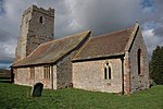 |
| Church of St Peter and St Paul | Birtsmorton, Malvern Hills | Church | 14th century | 25 March 1968 | SO8011535504 52°01′03″N2°17′28″W / 52.017599°N 2.291172°W | 1302867 | 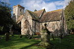 |
| Church of St Michael | Bockleton, Malvern Hills | Parish Church | 12th century | 18 April 1966 | SO5930261428 52°14′58″N2°35′51″W / 52.249515°N 2.597554°W | 1082473 | 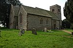 |
| Church of St John the Baptist | Bransford, Malvern Hills | Church | 13th century | 29 July 1959 | SO7970351559 52°09′43″N2°17′53″W / 52.161925°N 2.298137°W | 1098793 | 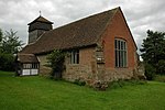 |
| Butts Farmhouse | Butts Bank, Broadwas, Malvern Hills | Farmhouse | 15th century | 12 November 1951 | SO7624755235 52°11′41″N2°20′56″W / 52.194835°N 2.348917°W | 1349343 |  Upload Photo |
| Church of St Mary Magdalene | Broadwas, Malvern Hills | Parish Church | Late 12th century | 29 July 1959 | SO7549655126 52°11′38″N2°21′36″W / 52.193822°N 2.359896°W | 1349345 | 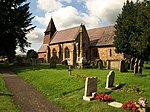 |
| Stone Farmhouse and Attached Hop Kiln | Broadwas, Malvern Hills | Farmhouse | 15th century | 12 November 1951 | SO7557155331 52°11′44″N2°21′32″W / 52.195668°N 2.358814°W | 1082977 | Upload Photo |
| Mythe Bridge (that Part in Civil Parish of Bushley) | Bushley, Malvern Hills | Road Bridge | 1825 | 11 August 1952 | SO8885833736 52°00′07″N2°09′49″W / 52.001949°N 2.163713°W | 1282810 | 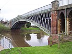 |
| Paynes Place | Bushley, Malvern Hills | House | 16th century | 11 August 1952 | SO8734334023 52°00′16″N2°11′09″W / 52.004497°N 2.185792°W | 1082219 |  |
| Pull Court, Screen, Archway and Gates | Bushley, Malvern Hills | Country House | 1834-39 | 25 March 1968 | SO8621736086 52°01′23″N2°12′08″W / 52.023018°N 2.202279°W | 1082217 | 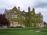 |
| Bannut Tree House | Castlemorton, Malvern Hills | House | 1890 | 23 February 1987 | SO7854237643 52°02′12″N2°18′51″W / 52.03677°N 2.314228°W | 1156932 |  |
| Church of St Kenelm | Clifton-upon-Teme, Malvern Hills | Parish Church | 13th century | 29 July 1959 | SO7149361611 52°15′07″N2°25′08″W / 52.251929°N 2.419005°W | 1083009 |  |
| Woodmanton Farmhouse, Kitchen, Outbuildings and Tower Base | Clifton upon Teme, Malvern Hills | Farmhouse | About 1827 | 12 November 1951 | SO7189660476 52°14′30″N2°24′47″W / 52.241746°N 2.413007°W | 1302591 | Upload Photo |
| Church of St Leonard | Cotheridge, Malvern Hills | Parish Church | Early 12th century | 29 July 1959 | SO7867054739 52°11′26″N2°18′48″W / 52.190475°N 2.313439°W | 1179067 |  |
| Cotheridge Court | Cotheridge, Malvern Hills | Country House | Late C16 | 12 November 1951 | SO7846854630 52°11′22″N2°18′59″W / 52.189487°N 2.316387°W | 1082941 | Upload Photo |
| Church of St Nicholas | Earls Croome, Malvern Hills | Church | Norman | 25 March 1968 | SO8703542025 52°04′35″N2°11′26″W / 52.076432°N 2.190585°W | 1302545 | 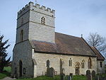 |
| Dunstall Castle | Dunstall Common, Earls Croome, Malvern Hills | Castle | 1750-60 | 25 March 1968 | SO8856242898 52°05′04″N2°10′06″W / 52.084315°N 2.168334°W | 1082583 | 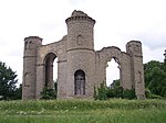 |
| Lower House Farmhouse | Eastham, Malvern Hills | Farmhouse | c. 1750 | 6 October 1952 | SO6762668098 52°18′36″N2°28′35″W / 52.310032°N 2.476274°W | 1081442 | 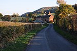 |
| Puddleford Farmhouse and adjoining Cider House and Hop Kilns | Eastham, Malvern Hills | Farmhouse | c. 1600 | 6 October 1952 | SO6843767992 52°18′33″N2°27′52″W / 52.309127°N 2.464369°W | 1350031 | Upload Photo |
| Robin's End | Eastham, Malvern Hills | House | c. 1735 | 18 April 1966 | SO6604368165 52°18′38″N2°29′58″W / 52.310539°N 2.499499°W | 1081444 | 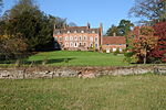 |
| Church of St John Baptist | Eldersfield, Malvern Hills | Church | 12th century | 25 March 1968 | SO7998831172 51°58′43″N2°17′34″W / 51.978647°N 2.292768°W | 1349234 | 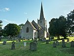 |
| Hardwick Farmhouse | Eldersfield, Malvern Hills | Farmhouse | Late 14th century | 28 March 1988 | SO8171732730 51°59′34″N2°16′04″W / 51.992714°N 2.267679°W | 1078234 | Upload Photo |
| The Red House | Eldersfield, Malvern Hills | House | Mid 17th century | 5 December 1974 | SO7933230056 51°58′07″N2°18′08″W / 51.968589°N 2.302251°W | 1098841 | Upload Photo |
| Curved Linking Wing, Pavilion and Orangery and including Five-arched Arcade to rear of Link - South-west of Witley Court | Witley Park, Great Witley, Malvern Hills | Orangery | c. 1860 | 27 November 1984 | SO7692364918 52°16′55″N2°20′23″W / 52.281915°N 2.339692°W | 1349485 |  |
| Home Farm House | Woodbury Hill, Great Witley, Malvern Hills | Farmhouse | c. 1500 | 27 November 1984 | SO7519665234 52°17′05″N2°21′54″W / 52.284681°N 2.36503°W | 1302892 | Upload Photo |
| Triton Fountain c.80m east of East Front of Witley Court | Witley Park, Great Witley, Malvern Hills | Statue | c. 1860 | 12 November 1951 | SO7709664905 52°16′55″N2°20′14″W / 52.281806°N 2.337156°W | 1082660 |  |
| Church of St Bartholomew | Grimley, Malvern Hills | Parish Church | 12th century | 29 July 1959 | SO8363060682 52°14′39″N2°14′28″W / 52.244075°N 2.241173°W | 1349352 | 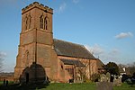 |
| Old Hill Farmhouse | Grimley, Malvern Hills | Farmhouse | Late 16th century | 15 October 1984 | SO8156461545 52°15′06″N2°16′17″W / 52.251768°N 2.271478°W | 1082945 | Upload Photo |
| Thorngrove | Grimley, Malvern Hills | Country House | Late 18th century | 29 July 1959 | SO8220960095 52°14′20″N2°15′43″W / 52.238753°N 2.261953°W | 1179144 |  |
| Church of St Philip and St James | Hallow, Malvern Hills | Parish Church | 1867-9 | 15 October 1984 | SO8285157927 52°13′09″N2°15′09″W / 52.219283°N 2.252441°W | 1349353 | 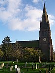 |
| Church of All Saints | Hanley William, Hanley, Malvern Hills | Parish Church | 12th century | 18 April 1966 | SO6730965976 52°17′27″N2°28′51″W / 52.290937°N 2.480716°W | 1296918 |  |
| Church of St Mary | Hanley Castle, Malvern Hills | Church | Early 14th century | 25 March 1968 | SO8388341944 52°04′32″N2°14′12″W / 52.075621°N 2.236572°W | 1349232 | 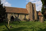 |
| Severn End | Hanley Castle, Malvern Hills | Country House | 16th century | 11 August 1952 | SO8455742643 52°04′55″N2°13′36″W / 52.081925°N 2.22677°W | 1098805 |  |
| Baughton Court | Baughton, Hill Croome, Malvern Hills | Timber Framed House | 15th century to 17th century | 11 August 1952 | SO8780341936 52°04′32″N2°10′46″W / 52.07565°N 2.179376°W | 1157153 | 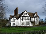 |
| Church of St Mary | Hill Croome, Hill Croome, Malvern Hills | Church | 13th century | 25 March 1968 | SO8879240422 52°03′43″N2°09′54″W / 52.062059°N 2.164896°W | 1082590 |  |
| Glebe Farmhouse | Hill Croome, Malvern Hills | Farmhouse | 14th century to 17th century | 11 August 1952 | SO8872340381 52°03′42″N2°09′57″W / 52.061689°N 2.165901°W | 1099073 | Upload Photo |
| Hillhampton House | Hillhampton, Malvern Hills | House | 17th century | 12 November 1951 | SO7747665422 52°17′11″N2°19′54″W / 52.286469°N 2.33162°W | 1082666 | Upload Photo |
| Great House and attached Outbuilding adjoining to Rear | Bickley, Knighton on Teme, Malvern Hills | Farmhouse | c. 1600 | 6 October 1952 | SO6418971278 52°20′18″N2°31′37″W / 52.338406°N 2.527024°W | 1350059 | Upload Photo |
| Manor House | Knightwick, Malvern Hills | Farmhouse | Early 18th century | 12 November 1951 | SO7216855061 52°11′35″N2°24′31″W / 52.193079°N 2.408576°W | 1156867 |  |
| Church of St Mary | Kyre Park, Kyre, Malvern Hills | Parish Church | 12th century | 18 April 1966 | SO6264663515 52°16′07″N2°32′56″W / 52.268515°N 2.548806°W | 1179365 |  |
| Dovecote about 120m north-east of Kyre Park | Kyre, Malvern Hills | Dovecote | c1600 or earlier | 18 April 1966 | SO6273763572 52°16′09″N2°32′51″W / 52.269033°N 2.547479°W | 1179454 | 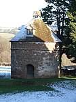 |
| Little Malvern Court | Little Malvern, Malvern Hills | House | Mid 16th century | 11 August 1952 | SO7699140368 52°03′40″N2°20′13″W / 52.061207°N 2.337022°W | 1178481 | 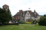 |
| Church of Saint Mary | Longdon Village, Longdon, Malvern Hills | Church | c. 1300 | 25 March 1968 | SO8382536256 52°01′28″N2°14′14″W / 52.024481°N 2.237147°W | 1238836 |  |
| Longdon Hall | Longdon, Malvern Hills | Jettied House | 16th century | 11 August 1952 | SO8411134976 52°00′47″N2°13′59″W / 52.012981°N 2.232919°W | 1238531 | Upload Photo |
| The Moat House | Longdon Village, Longdon, Malvern Hills | Moat | 16th century | 25 March 1968 | SO8391236121 52°01′24″N2°14′09″W / 52.02327°N 2.235872°W | 1238754 | Upload Photo |
| Old Church of St Bartholomew | Lower Sapey, Malvern Hills | Church | Early 12th century | 29 July 1959 | SO6993060207 52°14′21″N2°26′30″W / 52.239224°N 2.441774°W | 1098648 | 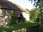 |
| Lulsley Court | Lulsley, Malvern Hills | Farmhouse | 16th century | 12 November 1951 | SO7444155982 52°12′05″N2°22′31″W / 52.201469°N 2.375395°W | 1156981 | 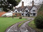 |
| Abbey Gateway | Malvern, Malvern Hills | Abbey | 15th century | 30 November 1949 | SO7753145849 52°06′38″N2°19′46″W / 52.110506°N 2.329509°W | 1349407 | 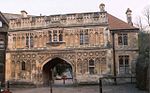 |
| Chapel and Cloister at the Convent of the Holy Name | Malvern, Malvern Hills | Chapel | 1891-1893 | 4 June 1973 | SO7913448052 52°07′49″N2°18′22″W / 52.130375°N 2.306238°W | 1082736 |  |
| Main Building of Malvern College | Malvern, Malvern Hills | School | 1862 | 1 January 1970 | SO7775745143 52°06′15″N2°19′34″W / 52.104168°N 2.326163°W | 1082796 |  |
| Laughern House School | Martley, Malvern Hills | Country House | Late 18th century | 12 November 1951 | SO7661459593 52°14′03″N2°20′38″W / 52.23403°N 2.343851°W | 1178570 | 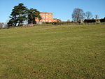 |
| Warden's Lodge, Boardroom, Chapel, Library and attached Buildings to East of Courtyard at Beauchamp Almshouses | Newland, Malvern Hills | House | 1863 | 9 February 1988 | SO7960648460 52°08′03″N2°17′58″W / 52.13406°N 2.299368°W | 1349271 | Upload Photo |
| Church of Saint Nicholas | Queenhill, Queenhill, Malvern Hills | Church | 11th century | 25 March 1968 | SO8607336647 52°01′41″N2°12′16″W / 52.028058°N 2.204401°W | 1239009 |  |
| Church of St Michael | Rochford, Malvern Hills | Parish Church | 12th century | 18 April 1966 | SO6291868506 52°18′48″N2°32′43″W / 52.313401°N 2.545371°W | 1082446 |  |
| Church of St Denys | Severn Stoke, Malvern Hills | Anglican Church | 1872 | 25 March 1968 | SO8560043991 52°05′39″N2°12′42″W / 52.094072°N 2.211607°W | 1178488 | 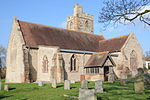 |
| The Owl House (Owl's Nest) at South End of Lake | Croome Park, Severn Stoke, Malvern Hills | Garden Temple | c. 1766 | 25 March 1968 | SO8895043646 52°05′28″N2°09′46″W / 52.091048°N 2.162697°W | 1178399 | 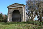 |
| Church of All Saints | Shelsey Beauchamp, Shelsley Beauchamp, Malvern Hills | Parish Church | 14th century | 27 November 1984 | SO7310962856 52°15′48″N2°23′44″W / 52.263204°N 2.395433°W | 1349514 | 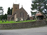 |
| Remains of Churchyard Cross | Shelsey Beauchamp, Shelsley Beauchamp, Malvern Hills | Cross | 15th century | 29 July 1959 | SO7312062844 52°15′47″N2°23′43″W / 52.263096°N 2.395271°W | 1082633 | Upload Photo |
| Base of Churchyard Cross about 5m south of Church of St Mary | Shrawley, Shrawley, Malvern Hills | Cross | 14th century | 29 July 1959 | SO8060964782 52°16′51″N2°17′08″W / 52.280836°N 2.285655°W | 1302738 | Upload Photo |
| Church of St Mary | Stanford on Teme, Stanford with Orleton, Malvern Hills | Parish Church | 1768-9 | 18 April 1966 | SO7024065728 52°17′20″N2°26′16″W / 52.288875°N 2.437723°W | 1173236 | 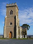 |
| Church of St Andrew | Stockton on Teme, Stockton on Teme, Malvern Hills | Parish Church | Mid 12th century | 18 April 1966 | SO7161467339 52°18′12″N2°25′04″W / 52.30343°N 2.417717°W | 1082110 | 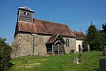 |
| Stables and adjoining Shelter Shed about 20m north-east of the Hyde | Stoke Bliss, Malvern Hills | Stables | 19th century | 6 October 1952 | SO6286961941 52°15′16″N2°32′43″W / 52.25438°N 2.545364°W | 1082454 | Upload Photo |
| Stoke Bliss Church | Stoke Bliss, Stoke Bliss, Malvern Hills | Parish Church | 12th century | 18 April 1966 | SO6514262850 52°15′46″N2°30′44″W / 52.262701°N 2.512162°W | 1179715 | 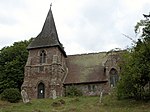 |
| The Hyde and adjoining Hop Kiln | Stoke Bliss, Malvern Hills | Farmhouse | 14th century | 6 October 1952 | SO6285461928 52°15′15″N2°32′44″W / 52.254262°N 2.545583°W | 1082453 | Upload Photo |
| Lower Tundridge Farmhouse | Suckley, Malvern Hills | Farmhouse | c. 1650 | 29 July 1959 | SO7357151144 52°09′29″N2°23′16″W / 52.157933°N 2.387746°W | 1082207 | Upload Photo |
| Church of St Mary | Tenbury Wells, Malvern Hills | Church | Anglo-Saxon | 18 April 1966 | SO5944268368 52°18′43″N2°35′47″W / 52.311914°N 2.59634°W | 1082426 |  |
| Church of St Michael and All Angels | St Michaels, Tenbury, Malvern Hills | Anglican Church | 1856-1858 | 24 October 1988 | SO5826865753 52°17′18″N2°36′48″W / 52.288318°N 2.613235°W | 1349604 |  |
| Cornwall House | Tenbury, Malvern Hills | House | Late 17th century | 6 October 1952 | SO5945768041 52°18′32″N2°35′46″W / 52.308976°N 2.596081°W | 1179894 | 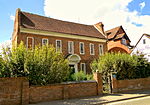 |
| Nos 5 and 6, Market Square and adjoining Railings to Front | Tenbury, Malvern Hills | House | Early 18th century | 6 October 1952 | SO5947868221 52°18′38″N2°35′45″W / 52.310596°N 2.595795°W | 1180022 | Upload Photo |
| Pump Room, Brine Baths and Reading Room | Tenbury, Malvern Hills | Spring | c. 1862 | 7 March 1972 | SO5968768288 52°18′40″N2°35′34″W / 52.311213°N 2.592737°W | 1082404 | 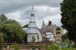 |
| St Michael's College and adjoining Cloister | St Michaels, Tenbury, Malvern Hills | Theological College | 1856-8 | 24 October 1988 | SO5829265714 52°17′17″N2°36′46″W / 52.287969°N 2.612878°W | 1349605 |  |
| Parish Church of Saint Peter and Saint Paul | Upton-upon-Severn, Malvern Hills | Parish Church | 1831 | 25 March 1968 | SO8515140277 52°03′38″N2°13′05″W / 52.060669°N 2.217998°W | 1227107 | 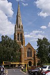 |
| Tower of Former Parish Church | Upton-upon-Severn, Malvern Hills | Bell Tower | 14th century | 25 March 1968 | SO8515340695 52°03′52″N2°13′05″W / 52.064427°N 2.217987°W | 1226692 |  |
| 2–6 Church Street | Upton-upon-Severn, Malvern Hills | House | Late 16th century | 25 March 1968 | SO8512440684 52°03′52″N2°13′06″W / 52.064328°N 2.218409°W | 1082244 | Upload Photo |
| Church of St Lawrence | Wichenford, Malvern Hills | Parish Church | 12th century | 29 July 1959 | SO7871960147 52°14′21″N2°18′47″W / 52.239096°N 2.313064°W | 1082931 | 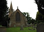 |
| Dovecote at Wichenford Court | Wichenford, Malvern Hills | Dovecote | 17th century | 15 October 1984 | SO7871859872 52°14′12″N2°18′47″W / 52.236624°N 2.313061°W | 1301822 |  |
| Wichenford Court | Wichenford, Malvern Hills | House | 15th century | 12 November 1951 | SO7879059835 52°14′11″N2°18′43″W / 52.236294°N 2.312005°W | 1082896 | Upload Photo |
| Council House | Malvern | House | 1880 | 11 May 1979 | SO7785245896 52°06′39″N2°19′29″W / 52.110941°N 2.3248251°W | 1156369 | 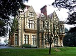 |

There are over 9000 Grade I listed buildings in England. This page is a list of these buildings in the county of Cumbria, sub-divided by district.
There are over 9,000 Grade I listed buildings in England. This is a list of these buildings and structures in the county of Dorset, grouped first by the two unitary authority areas: first Bournemouth, Christchurch and Poole, then Dorset.
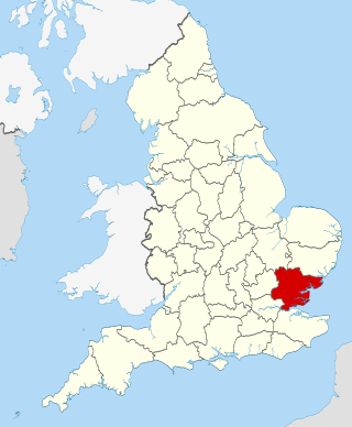
There are over 9000 Grade I listed buildings in England. This page is a list of these buildings in the county of Essex.

There are over 9,000 Grade I listed buildings in England. This page is a list of these buildings in the county of Hertfordshire, organised by district.

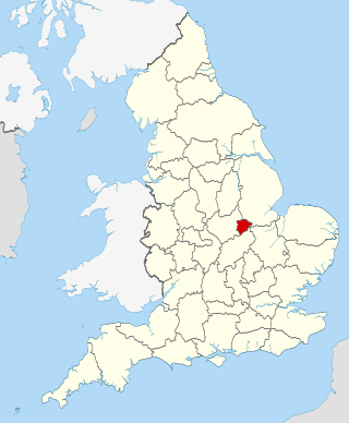
There are over 9,000 Grade I listed buildings in England. This page is a list of these buildings in the county of Nottinghamshire, by district.

There are over 9000 Grade I listed buildings in England. The following is a selected list of these buildings in the county of Shropshire, organised by district.

There are over 9000 Grade I listed buildings in England. This page is a list of these buildings in the county of Staffordshire, by district.

There are over 9,000 Grade I listed buildings in England. This page is a list of these buildings in the county of West Yorkshire, by metropolitan district.

There are over 20,000 Grade II* listed buildings in England. This page is a list of the 183 of these buildings in the ceremonial county of the East Riding of Yorkshire.
There are over 20,000 Grade II* listed buildings in England. This page is a list of the 71 of these buildings in the county of Rutland.

There are over 20,000 Grade II* listed buildings in England. This list includes those in South Yorkshire.
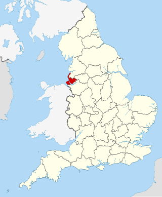
There are over 20,000 Grade II* listed buildings in England. This page is a list of these buildings in the county of Merseyside.
There are over 20,000 Grade II* listed buildings in England. This page is a list of these buildings in the county of Nottinghamshire, by district.

There are over 20,000 Grade II* listed buildings in England. This page is a list of these buildings in the county of West Midlands, by district.
This is a list of Grade II* listed buildings in Lancashire, England.
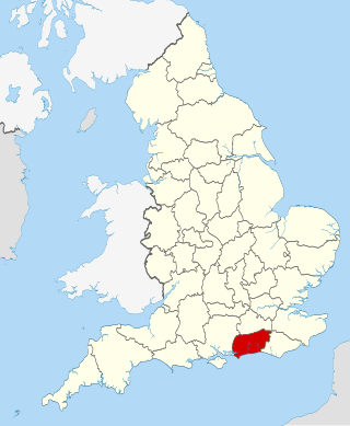
There are over 20,000 Grade II* listed buildings in England. This page is a list of these buildings in the county of West Sussex by district.
There are over 20,000 Grade II* listed buildings in England. This page is a list of these buildings in the Borough of Basildon in Essex.
There are over 20,000 Grade II* listed buildings in England. This page is a list of these buildings in the district of Braintree in Essex.
There are over 20,000 Grade II* listed buildings in England. This is a list of these buildings in the London Borough of Richmond upon Thames.
There are over 20,000 Grade II* listed buildings in England. This page is a list of these buildings in the district of Welwyn Hatfield in Hertfordshire.