Hammonds Plains, Upper Sackville and Beaverbank | |
---|---|
Planning Area | |
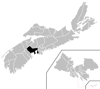
Location of Hammonds Plains, Upper Sackville and Beaverbank planning area of municipal Halifax | |
Coordinates: 44°49′N63°45′W / 44.81°N 63.75°W Coordinates: 44°49′N63°45′W / 44.81°N 63.75°W | |
Country | |
Province | |
Municipality | Halifax Regional Municipality |
Founded | 1996 (as planning area) |
Communities | Hammonds Plains, Upper Sackville, Beaver Bank |
Government | |
• Councils | Marine Drive, Valley & Canal, and Western Region Councils |
Time zone | AST (UTC-4) |
Postal code span | B |
Area code(s) | 902 |
Part of a series about Places in Nova Scotia |
Hammonds Plains, Upper Sackville and Beaver Bank is a planning area in the Halifax Regional Municipality, Nova Scotia. The area wraps from Exit 5 on Highway 103 to the west of the urban core of Halifax, and runs north and east, wrapping clockwise around the harbour along the Hammonds Plains Road, Lucasville Road and Sackville Drive, through Upper Sackville to Beaverbank.
Nova Scotia is one of Canada's three Maritime Provinces, and one of the four provinces that form Atlantic Canada. Its provincial capital is Halifax. Nova Scotia is the second-smallest of Canada's ten provinces, with an area of 55,284 square kilometres (21,300 sq mi), including Cape Breton and another 3,800 coastal islands. As of 2016, the population was 923,598. Nova Scotia is Canada's second-most-densely populated province, after Prince Edward Island, with 17.4 inhabitants per square kilometre (45/sq mi).
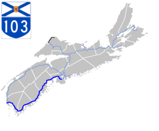
Highway 103 is an east-west highway in Nova Scotia that runs from Halifax to Yarmouth.
Hammonds Plains lies at the neck of the Chebucto Peninsula along a road that runs from Bedford to the Head of St. Margarets Bay within the Halifax Regional Municipality Nova Scotia. Upper Sackville is a Canadian suburban community in Nova Scotia's Halifax Regional Municipality. It is situated in the Sackville River valley immediately north of Middle Sackville and south of Mount Uniacke on Trunk 1. Upper Sackville is approximately 23 kilometers driving distance from downtown Halifax. Beaver Bank is a community northeast of Lower Sackville on the Beaver Bank Road (Route 354) within the Halifax Regional Municipality Nova Scotia that is 25 Kilometers from the community of Halifax.
Hammonds Plains is a suburban community located in Halifax Regional Municipality, Nova Scotia, Canada
The Chebucto Peninsula is a Canadian peninsula located in central Nova Scotia entirely within the Halifax Regional Municipality on the Atlantic coast.
Bedford is a suburban community of Halifax, Nova Scotia, Canada. It was an independent town from 1980 to 1996. Bedford is on the northwestern end of Bedford Basin, an extension of the Halifax Harbour, which ends just before Nova Scotia Highway 102 and the Bedford Bypass, next to Lower Sackville. Bedford is at the junctions of Trunks 1, 2, and 7.
Beaver Bank is a suburban community northeast of Lower Sackville on the Beaver Bank Road within the Halifax Regional Municipality, Nova Scotia, Canada. It is about 35 kilometres from the City of Halifax.
Kinsac is a suburban community in District 2 of the Halifax Regional Municipality, in Nova Scotia, Canada on Nova Scotia Route 354.
Lucasville is a Black Nova Scotian settlement within the Halifax Regional Municipality in the Canadian province of Nova Scotia.
Lower Sackville is a suburban community of Halifax, Nova Scotia, Canada. It lies just outside the urban core of the Halifax Regional Municipality.
Chester—St. Margaret's is a provincial electoral district in Nova Scotia, Canada, that elects one member of the Nova Scotia House of Assembly. It is located on the South Shore.
Highway 107 in Nova Scotia runs through the eastern suburbs of the Halifax Regional Municipality, from the Burnside Industrial Park in Dartmouth to an intersection with Trunk 7 in Musquodoboit Harbour. It is 41 km (25 mi) long, and is mostly two lane, controlled access highway.
Timberlea—Prospect is a provincial electoral district in Nova Scotia, Canada, that elects one member of the Nova Scotia House of Assembly. Its Member of the Legislative Assembly (MLA) since 2013 has been Iain Rankin of the Nova Scotia Liberal Party.
Sackville—Cobequid is a provincial electoral district in Nova Scotia, Canada, that elects one member of the Nova Scotia House of Assembly.
Hammonds Plains—Upper Sackville is a former provincial electoral district in Nova Scotia, Canada which existed from 2003-2013. It elected one member of the Nova Scotia House of Assembly. In its last configuration, the electoral district included those communities comprising the western suburbs of the Halifax Regional Municipality, namely Hammonds Plains, Yankeetown, Pockwock, Upper Sackville and Lucasville.
Trunk 1 is a secondary highway in the Canadian province of Nova Scotia.
Route 213 is a collector road in the Canadian province of Nova Scotia. It is located in the Halifax Regional Municipality, connecting Bedford at Trunk 2 with Upper Tantallon at Trunk 3 with interchanges with Highway 102 and Highway 103 located near the termini.
The Bedford Highway is a highway in the Halifax Regional Municipality, Nova Scotia that is part of Trunk 2. It runs around the western side of the Bedford Basin. The highway starts at the Windsor Street intersection on the Halifax Peninsula and passes by the communities of Fairview, Rockingham, and Bedford, where it becomes part of Trunk 1 to Highway 101.
Upper Tantallon is a suburban community that extends from the Hammonds Plains Road to the crossroads of Trunk 3 and Route 333 within the Halifax Regional Municipality, 22.3 km west from Halifax, Nova Scotia, Canada. The community is likely named for Tantallon Castle in Scotland.
Halifax, Nova Scotia, is a major multi-modal transportation centre for freight and passengers in Atlantic Canada.
Sackville-Beaver Bank is a provincial electoral district in Nova Scotia, Canada. It was created in 2012 from parts of much of Hammonds Plains-Upper Sackville and part of Waverley-Fall River-Beaver Bank. The riding also existed from 1993 to 2003.
Barry Barnet is a Canadian politician. He represented the electoral districts of Sackville-Beaver Bank and Hammonds Plains-Upper Sackville in the Nova Scotia House of Assembly from 1999 to 2009. He was a member of the Progressive Conservative Party of Nova Scotia.
Pockwock is one of four Black Nova Scotian settlements in Upper Hammonds Plains. People in this area are mostly descendants of War of 1812 refugees. It is located in the Halifax Regional Municipality in the Canadian province of Nova Scotia. The Halifax Regional Water Commission uses Pockwock Lake as a source for water for the communities of Halifax, Bedford and Lower Sackville.
Mathew Whynott is a Canadian politician, who was elected to the Nova Scotia House of Assembly in the 2009 provincial election. From 2009 to 2013, he represented the electoral district of Hammonds Plains-Upper Sackville as a member of the New Democratic Party. He is the youngest person ever elected as MLA in Nova Scotia. Whynott is majoring in political science at St. Mary's University. He lives in Lucasville with his wife Charlotte and daughter Morgan.
Upper Hammonds Plains is a Canadian suburban community located in Nova Scotia's Halifax Regional Municipality.