Hanska, Minnesota

Last updated

Hanska
Hanska, Minnesota (1917).jpg
Hanska, 1917
Brown County Minnesota Incorporated and Unincorporated areas Hanska Highlighted.svg
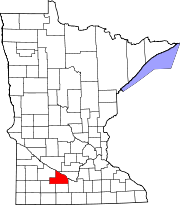
Location of Hanska, Minnesota
Coordinates: 44°08′55″N94°29′40″W / 44.14861°N 94.49444°W / 44.14861; -94.49444
Country United States
State Minnesota
County Brown
Government
  TypeMayor - Council
  MayorDaniel J Vee
Area
[1]
  Total0.25 sq mi (0.64 km2)
  Land0.25 sq mi (0.64 km2)
  Water0.00 sq mi (0.00 km2)
Elevation
[2]
1,020 ft (310 m)
Population
 (2020)
  Total382
  Density1,546.56/sq mi (598.03/km2)
Time zone UTC-6 (Central (CST))
  Summer (DST) UTC-5 (CDT)
ZIP code
56041
Area code 507
FIPS code 27-27008 [3]
GNIS feature ID2394291 [2]
Website www.cityofhanska.com

Hanska is a city in Brown County, Minnesota, United States. The population was 402 at the 2010 census. [4]

Contents

History

A post office called Hanska has been in operation since 1890. [5] Hanska was platted in 1899, and incorporated as a village in 1901. [6]

Geography

According to the United States Census Bureau, the city has a total area of 0.24 square miles (0.62 km2), all land. [7]

Demographics

Historical population
CensusPop.Note
1910 310
1920 41232.9%
1930 359−12.9%
1940 46128.4%
1950 4732.6%
1960 4913.8%
1970 442−10.0%
1980 429−2.9%
1990 4433.3%
2000 4430.0%
2010 402−9.3%
2020 382−5.0%
U.S. Decennial Census [8]

2010 census

As of the census [9] of 2010, there were 402 people, 176 households, and 105 families living in the city. The population density was 1,675.0 inhabitants per square mile (646.7/km2). There were 197 housing units at an average density of 820.8 per square mile (316.9/km2). The racial makeup of the city was 99.5% White, 0.2% African American, and 0.2% Asian. Hispanic or Latino of any race were 0.5% of the population.

There were 176 households, of which 31.3% had children under the age of 18 living with them, 46.0% were married couples living together, 7.4% had a female householder with no husband present, 6.3% had a male householder with no wife present, and 40.3% were non-families. 35.8% of all households were made up of individuals, and 12.5% had someone living alone who was 65 years of age or older. The average household size was 2.28 and the average family size was 2.98.

The median age in the city was 38.3 years. 24.9% of residents were under the age of 18; 6.5% were between the ages of 18 and 24; 30.1% were from 25 to 44; 23% were from 45 to 64; and 15.7% were 65 years of age or older. The gender makeup of the city was 51.7% male and 48.3% female.

2000 census

As of the census [3] of 2000, there were 443 people, 187 households, and 123 families living in the city. The population density was 1,856.5 inhabitants per square mile (716.8/km2). There were 196 housing units at an average density of 821.4 per square mile (317.1/km2). The racial makeup of the city was 99.10% White, 0.45% African American, 0.23% Native American and 0.23% Asian. Hispanic or Latino of any race were 0.23% of the population.

There were 187 households, out of which 31.6% had children under the age of 18 living with them, 55.6% were married couples living together, 3.2% had a female householder with no husband present, and 34.2% were non-families. 28.3% of all households were made up of individuals, and 16.0% had someone living alone who was 65 years of age or older. The average household size was 2.37 and the average family size was 2.92.

In the city, the population was spread out, with 24.6% under the age of 18, 9.0% from 18 to 24, 28.0% from 25 to 44, 21.4% from 45 to 64, and 16.9% who were 65 years of age or older. The median age was 35 years. For every 100 females, there were 103.2 males. For every 100 females age 18 and over, there were 103.7 males.

The median income for a household in the city was $40,114, and the median income for a family was $43,125. Males had a median income of $29,423 versus $18,611 for females. The per capita income for the city was $16,803. About 3.7% of families and 3.1% of the population were below the poverty line, including 1.9% of those under age 18 and 9.8% of those age 65 or over.

Related Research Articles

Albin Township is a township in Brown County, Minnesota, United States. The population was 329 at the 2000 census. Albin Township was organized in 1870.

Cottonwood Township is a township in Brown County, Minnesota, United States. The population was 938 as of the 2000 census.

Lake Hanska Township is a township in Brown County, Minnesota, United States. The population was 322 as of the 2000 census.

<span class="mw-page-title-main">Felton, Minnesota</span> City in Minnesota, United States

Felton is a city in Clay County, Minnesota, United States. The population was 177 at the 2020 census.

<span class="mw-page-title-main">Emily, Minnesota</span> City in Minnesota, United States

Emily is a city in Crow Wing County, Minnesota, United States. The population was 813 at the 2010 census. It is part of the Brainerd Micropolitan Statistical Area.

<span class="mw-page-title-main">Easton, Minnesota</span> City in Minnesota, United States

Easton is a city in Faribault County, Minnesota, United States. The population was 199 at the 2010 census.

<span class="mw-page-title-main">Calumet, Minnesota</span> City in Minnesota, United States

Calumet is a city in Itasca County, Minnesota, United States. The population was 367 at the 2010 census.

<span class="mw-page-title-main">Coleraine, Minnesota</span> City in Minnesota, United States

Coleraine is a city in Itasca County, Minnesota, United States. The population was 1,970 at the 2010 census. The community was named after Thomas F. Cole, President of the Oliver Iron Mining Company.

<span class="mw-page-title-main">Sunburg, Minnesota</span> City in Minnesota, United States

Sunburg is a city in Kandiyohi County, Minnesota, United States. The population was 100 at the 2010 census.

<span class="mw-page-title-main">Lake Bronson, Minnesota</span> City in Minnesota, United States

Lake Bronson is a city in Kittson County, Minnesota, United States. The population was 178 at the 2020 census. Lake Bronson State Park is nearby.

<span class="mw-page-title-main">Racine, Minnesota</span> City in Minnesota, United States

Racine is a city in Racine Township, Mower County, Minnesota, United States. The population was 442 at the 2010 census.

<span class="mw-page-title-main">Henning, Minnesota</span> City in Minnesota, United States

Henning is a city in Otter Tail County, Minnesota, United States. The population was 854 at the 2020 census.

<span class="mw-page-title-main">Parkers Prairie, Minnesota</span> City in Minnesota, United States

Parkers Prairie is a city in Otter Tail County, Minnesota, United States. The population was 1,020 at the 2020 census.

<span class="mw-page-title-main">Sedan, Minnesota</span> City in Minnesota, United States

Sedan is a city in Pope County, Minnesota, United States. The population was 43 at the 2020 census.

<span class="mw-page-title-main">Orr, Minnesota</span> City in Minnesota, United States

Orr is a city in Saint Louis County, Minnesota, United States. The population was 211 at the 2020 census.

<span class="mw-page-title-main">Clontarf, Minnesota</span> City in Minnesota, United States

Clontarf is a city in Swift County, Minnesota, United States. The population was 164 at the 2010 census.

<span class="mw-page-title-main">Clarissa, Minnesota</span> City in Minnesota, United States

Clarissa is a city in Todd County, Minnesota, United States. The population was 681 at the 2010 census. It dropped to 261 inhabitants by the 2020 census.

<span class="mw-page-title-main">Minnesota City, Minnesota</span> City in Minnesota, United States

Minnesota City is a city in Winona County, Minnesota, United States. The population was 202 at the 2020 census.

<span class="mw-page-title-main">Genola, Minnesota</span> City in Minnesota, United States

Genola is a city in Morrison County, Minnesota, United States. The population was 70 at the 2020 census.

<span class="mw-page-title-main">St. Stephen, Minnesota</span> City in Minnesota, United States

Saint Stephen is a city in Stearns County, Minnesota, United States. The population was 851 at the 2010 census.

References

  1. "2020 U.S. Gazetteer Files". United States Census Bureau. Retrieved July 24, 2022.
  2. 1 2 U.S. Geological Survey Geographic Names Information System: Hanska, Minnesota
  3. 1 2 "U.S. Census website". United States Census Bureau . Retrieved January 31, 2008.
  4. "2010 Census Redistricting Data (Public Law 94-171) Summary File". American FactFinder. United States Census Bureau . Retrieved April 27, 2011.[ dead link ]
  5. "Brown County". Jim Forte Postal History. Retrieved April 11, 2015.
  6. Upham, Warren (1920). Minnesota Geographic Names: Their Origin and Historic Significance. Minnesota Historical Society. p.  69.
  7. "US Gazetteer files 2010". United States Census Bureau . Retrieved November 13, 2012.
  8. "Census of Population and Housing". Census.gov. Retrieved June 4, 2015.
  9. "U.S. Census website". United States Census Bureau . Retrieved November 13, 2012.