Harrison Township, Carroll County, Ohio | |
---|---|
Coordinates: 40°36′48″N81°8′55″W / 40.61333°N 81.14861°W | |
Country | United States |
State | Ohio |
County | Carroll |
Area | |
• Total | 31.4 sq mi (81.2 km2) |
• Land | 31.3 sq mi (81.1 km2) |
• Water | 0.04 sq mi (0.1 km2) |
Elevation | 1,135 ft (346 m) |
Population (2020) | |
• Total | 2,397 |
• Density | 77/sq mi (29.6/km2) |
Time zone | UTC-5 (Eastern (EST)) |
• Summer (DST) | UTC-4 (EDT) |
FIPS code | 39-33782 [2] |
GNIS feature ID | 1085829 [1] |
Website | www |
Harrison Township is one of the fourteen townships of Carroll County, Ohio, United States. As of the 2020 census, the population was 2,397. [3]
Located in the west central part of the county, it borders the following townships:
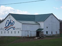
No municipalities are located in Harrison Township. The unincorporated community New Harrisburg is located centrally.
It is one of nineteen Harrison Townships statewide. [4]
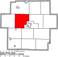
In 1817, Harrison Township was formed from a part of Sandy Township in Stark County. [5] The township originally was within Stark County until the formation of Carroll County. It had all of the original surveyed township 15, range 6 of the Old Seven Ranges, until the county commissioners took four and one-half sections in the formation of Centre (later Center) township. [6]
A route of the Underground Railroad passed through the township along Baxter Ridge. [7] [8]
Census | Pop. | Note | %± |
---|---|---|---|
1820 | 518 | — | |
1830 | 1,086 | 109.7% | |
1840 | 1,308 | 20.4% | |
1850 | 1,268 | −3.1% | |
1860 | 1,033 | −18.5% | |
1870 | 1,024 | −0.9% | |
1880 | 1,075 | 5.0% | |
1890 | 915 | −14.9% | |
1900 | 799 | −12.7% | |
1910 | 750 | −6.1% | |
1920 | 711 | −5.2% | |
1930 | 678 | −4.6% | |
1940 | 765 | 12.8% | |
1950 | 954 | 24.7% | |
1960 | 1,249 | 30.9% | |
1970 | 1,278 | 2.3% | |
1980 | 1,807 | 41.4% | |
1990 | 2,127 | 17.7% | |
2000 | 2,498 | 17.4% | |
2010 | 2,478 | −0.8% | |
2020 | 2,397 | −3.3% | |
[9] |
The township is governed by a three-member board of trustees, who are elected in November of odd-numbered years to a four-year term beginning on the following January 1. Two are elected in the year after the presidential election and one is elected in the year before it. There is also an elected township fiscal officer, [10] who serves a four-year term beginning on April 1 of the year after the election, which is held in November of the year before the presidential election. Vacancies in the fiscal officership or on the board of trustees are filled by the remaining trustees.
Students attend the Carrollton Exempted Village School District in most of the township and Brown Local School District in a corner of the township. [11]
Lake Township is one of the seventeen townships of Stark County, Ohio, United States. It is an urban township; the 2000 census found 25,892 people in the township, 23,718 of whom lived in the unincorporated portions of the township.
Pike Township is one of the seventeen townships of Stark County, Ohio, United States. The 2020 census found 3,818 people in the township, 3,069 of whom lived in the unincorporated portions of the township.
Union Township is one of the fourteen townships of Carroll County, Ohio, United States. As of the 2020 census, the population was 868.
Sugar Creek Township is one of the seventeen townships of Stark County, Ohio, United States. The 2000 census found 2,944 people in the township.
Sandy Township is one of the seventeen townships of Stark County, Ohio, United States. The 2020 census found 3,561 people in the township, 1,899 of whom lived in the unincorporated portions of the township.
Paris Township is one of the seventeen townships of Stark County, Ohio, United States. The 2000 census found 5,969 people in the township, 3,938 of whom lived in the unincorporated portions of the township.
Bethlehem Township is one of the seventeen townships of Stark County, Ohio, United States. The 2000 census found 4,210 people in the township.
Osnaburg Township is one of the seventeen townships of Stark County, Ohio, United States. The 2000 census found 5,886 people in the township, 4,257 of whom lived in the unincorporated portions of the township.
Perry Township is one of the fourteen townships of Carroll County, Ohio, United States. As of the 2020 census, the population was 934.
Orange Township is one of the fourteen townships of Carroll County, Ohio, United States. As of the 2020 census, the population was 1,133, 808 of whom lived in unincorporated portions of the township.
Augusta Township is one of the fourteen townships of Carroll County, Ohio, United States. As of the 2020 census it had a population of 1,531.
Brown Township is one of the fourteen townships of Carroll County, Ohio, United States. As of the 2020 census the township had a population of 7,214.
Center Township is one of the fourteen townships of Carroll County, Ohio, United States. As of the 2020 census there were 4,428 people living in the township, 1,341 of whom lived in the unincorporated portions of the township.
East Township is one of the fourteen townships of Carroll County, Ohio, United States. As of the 2020 census, the population was 808.
Fox Township is one of the fourteen townships of Carroll County, Ohio, United States. As of the 2020 census, the population was 977.
Lee Township is one of the fourteen townships of Carroll County, Ohio, United States. As of the 2020 census, the population was 1,022.
Loudon Township is one of the fourteen townships of Carroll County, Ohio, United States. As of the 2020 census, the population was 925.
Monroe Township is one of the fourteen townships of Carroll County, Ohio, United States. As of the 2020 census, the population was 1,924, 1,632 of whom lived in the unincorporated portions of the township.
Rose Township is one of the fourteen townships of Carroll County, Ohio, United States. As of the 2020 census, the population was 1,444, 1,168 of whom lived in the unincorporated portions of the township.
Washington Township is one of the fourteen townships of Carroll County, Ohio, United States. As of the 2020 census, the population was 1,116.