
Newlyn is a seaside town and fishing port in south-west Cornwall, England, United Kingdom. It is the largest fishing port in England.

Cape Cornwall is a small headland in West Cornwall, England. It is 4 miles (6.4 km) north of Land's End near the town of St Just. Until the first Ordnance Survey in the early 19th-century, Cape Cornwall was believed to be the most westerly point in Cornwall.

Kelly Bray is a village in east Cornwall, England, United Kingdom. It is situated one mile (1.6 km) north of Callington, immediately west of Kit Hill in a former mining area. Kelly Bray is in the parish of Callington and lies within the St Dominick, Harrowbarrow and Kelly Bray division on Cornwall Council. The population was 3,949 at the 2011 census. Kelly Bray is first recorded ca. 1286 as Kellibregh.

Calstock is a civil parish and a large village in south east Cornwall, England, United Kingdom, on the border with Devon. The village is situated on the River Tamar 6 miles (9.7 km) south west of Tavistock and 10 miles (16 km) north of Plymouth.

Gunwalloe is a coastal civil parish in Cornwall, England, United Kingdom. It is situated on the Lizard Peninsula three miles (4.8 km) south of Helston and partly contains The Loe, the largest natural freshwater lake in Cornwall. The parish population including Berepper at the 2011 census was 219. The hamlets in the parish are Chyanvounder, Berepper and Chyvarloe. To the east are the Halzephron cliffs and further east the parish church.
Colan is a village and civil parish in mid-Cornwall, England, United Kingdom. It is situated approximately three miles (5 km) east of Newquay. The electoral ward is called Colan and Mawgan. The population of this ward at the 2011 census was 4,256 The hamlets of Bosoughan, Chapel, Gwills, Kestle Mill, Lane, Mountjoy, Quintrell Downs, Trebarber and Trencreek are in the parish. The Fir Hill, and Firhill Woods near Nanswhyden, contains the ruins of Fir Hill Manor. Colan Church dates back to the thirteenth century.

Kenwyn is a settlement and civil parish in Cornwall, England, United Kingdom. The settlement is a suburb of the city of Truro and lies 0.5 mi (1 km) north of the city centre, within Truro parish, whereas Kenwyn parish covers an area west and north-west of the city. Kenwyn gives its name to one of three rivers that flow through the city.

Perranzabuloe is a coastal civil parish and a hamlet in Cornwall, England, United Kingdom. Perranzabuloe parish is bordered to the west by the Atlantic coast and St Agnes parish, to the north by Cubert parish, to the east by St Newlyn East and St Allen parishes and to the south by Kenwyn parish. The hamlet is situated just over a mile (2 km) south of the principal settlement of the parish, Perranporth; the hamlet is also seven miles (11 km) south-southwest of Newquay. Other settlements in the parish include Perrancoombe, Goonhavern, Mount and Callestick. The parish population was 5,382 in the 2001 census, increasing to 5,486 at the 2011 census.

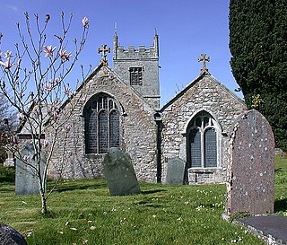
St Martin-in-Meneage is a civil parish and village in the Meneage district of the Lizard Peninsula in Cornwall, England, United Kingdom.

Lesnewth is a civil parish and village in Cornwall, England, United Kingdom. It is about six miles east of Tintagel Head and two miles east of Boscastle.

Helland is a civil parish and village in Cornwall, England, United Kingdom. It is situated 2+1⁄2 miles (4.0 km) north of Bodmin. The meaning of the name Helland is unclear: it is possible that the origin is in Cornish hen & lan. The original dedication of the church is unknown but St Helena is now recognised as the patron.

Baldhu is a village and parish in Cornwall, England, United Kingdom. It is in the civil parish of Kea.

Tresmeer is a hamlet and a civil parish in northeast Cornwall, England, United Kingdom. The hamlet is situated approximately seven miles (11 km) northwest of Launceston.
St John is a coastal civil parish and a village in south-east Cornwall, England, United Kingdom, 3 miles (4.8 km) south of Saltash and 1.5 miles (2.4 km) south-west of Torpoint.

St Dominic is a civil parish and village in Cornwall, England, United Kingdom. The village is situated 2+1⁄2 miles (4.0 km) east of Callington and five miles (8 km) north of Saltash.

Porthilly is a small coastal settlement on the east side of the River Camel estuary in Cornwall, England, United Kingdom. It is situated immediately south of the larger village of Rock approximately four miles (6.5 km) northwest of Wadebridge.
Menadarva is a hamlet in the parish of Camborne, Cornwall, England, UK. The Red River flows through the hamlet and on 9 March 1885 the machinery and materials of the Menadarva Lower Tin-Stream was put up for auction.
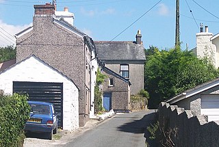
Norris Green is a village in Cornwall, England, UK. It was enlarged from a farming hamlet so that it now adjoins the neighbouring village of Higher Metherell. Both settlements are within the civil parish of Calstock which borders the River Tamar, the county boundary with Devon in south-east Cornwall.

Ponsongath is a hamlet west of Coverack in west Cornwall, England.

St Dominick, Harrowbarrow and Kelly Bray was an electoral division of Cornwall in the United Kingdom which returned one member to sit on Cornwall Council between 2013 and 2021. It was abolished at the 2021 local elections, being succeeded by Calstock and Callington and St Dominic.

