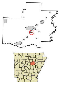
Higginson, Arkansas | |
---|---|
Coordinates: 35°11′49″N91°42′55″W / 35.19694°N 91.71528°W | |
Country | United States |
State | Arkansas |
County | White |
Area | |
• Total | 1.27 sq mi (3.29 km2) |
• Land | 1.27 sq mi (3.29 km2) |
• Water | 0.00 sq mi (0.00 km2) |
Elevation | 217 ft (66 m) |
Population (2020) | |
• Total | 705 |
• Density | 555.12/sq mi (214.36/km2) |
Time zone | UTC-6 (Central (CST)) |
• Summer (DST) | UTC-5 (CDT) |
ZIP code | 72068 |
Area code | 501 |
FIPS code | 05-32140 |
GNIS feature ID | 2405827 [2] |
Higginson is a second-class city [3] [4] in White County, Arkansas, United States. Randall Homsley is the current mayor and was a volunteer police officer until[ when? ] the volunteer police force was disbanded. [5]
The population was 621 at the 2010 census.
According to the United States Census Bureau, the town has a total area of 0.8 square miles (2.1 km2), all land.
The climate in this area is characterized by hot, humid summers and generally mild to cool winters. According to the Köppen Climate Classification system, Higginson has a humid subtropical climate, abbreviated "Cfa" on climate maps. [6]
Census | Pop. | Note | %± |
---|---|---|---|
1910 | 192 | — | |
1920 | 239 | 24.5% | |
1930 | 195 | −18.4% | |
1940 | 166 | −14.9% | |
1950 | 131 | −21.1% | |
1960 | 183 | 39.7% | |
1970 | 343 | 87.4% | |
1980 | 333 | −2.9% | |
1990 | 255 | −23.4% | |
2000 | 378 | 48.2% | |
2010 | 621 | 64.3% | |
2020 | 705 | 13.5% | |
U.S. Decennial Census [7] |
As of the census [8] of 2000, there were 378 people, 145 households, and 103 families residing in the town. The population density was 493.6 inhabitants per square mile (190.6/km2). There were 165 housing units at an average density of 215.5 per square mile (83.2/km2). The racial makeup of the town was 97.35% White, 0.26% Native American, 0.26% Asian, and 2.12% from two or more races. 1.85% of the population were Hispanic or Latino of any race.
There were 145 households, out of which 31.0% had children under the age of 18 living with them, 59.3% were married couples living together, 7.6% had a female householder with no husband present, and 28.3% were non-families. 20.0% of all households were made up of individuals, and 4.8% had someone living alone who was 65 years of age or older. The average household size was 2.61 and the average family size was 3.06.
In the town, the population was spread out, with 25.4% under the age of 18, 11.1% from 18 to 24, 28.8% from 25 to 44, 27.0% from 45 to 64, and 7.7% who were 65 years of age or older. The median age was 34 years. For every 100 females, there were 95.9 males. For every 100 females age 18 and over, there were 101.4 males.
The median income for a household in the town was $25,114, and the median income for a family was $29,250. Males had a median income of $26,750 versus $17,344 for females. The per capita income for the town was $11,568. About 13.7% of families and 18.2% of the population were below the poverty line, including 28.8% of those under age 18 and 20.0% of those age 65 or over.
It is zoned to Searcy Public Schools, [9] which operates Searcy High School.
White County is a county located in the U.S. state of Arkansas. As of the 2020 census, the population was 76,822. The county seat is Searcy. White County is Arkansas's 31st county, formed on October 23, 1835, from portions of Independence, Jackson, and Pulaski counties and named for Hugh Lawson White, a Whig candidate for President of the United States. It is an alcohol prohibition or dry county, though a few private establishments can serve alcohol.
Almyra is a town in Arkansas County, Arkansas, United States. The population was 283 at the 2010 census.
Thornton is a city in Calhoun County, Arkansas, United States. The population was 407 as of the 2010 census, down from 517 in 2000. It is part of the Camden, Arkansas micropolitan area.
Beaver is a town in Carroll County, Arkansas, United States. As of the 2020 census it had a population of 67. The community is located on the White River at the western limits of Table Rock Lake deep in the Ozark Mountains. Located north of Eureka Springs, the small town has been featured in movies for its picturesque scenery. The town is known for the Beaver Bridge, a two-panel suspension bridge over the White River listed on the National Register of Historic Places.
Mountainburg is a town in Crawford County, Arkansas, United States. It is part of the Fort Smith, Arkansas-Oklahoma Metropolitan Statistical Area. As of the 2010 census the population was 631.
Mountain Pine is a city in Garland County, Arkansas, United States. It is part of the Hot Springs Metropolitan Statistical Area. The population was 770 at the 2010 United States Census. It is located immediately southeast of Lake Ouachita below the Blakely Mountain Dam. The city consists of five defined neighborhoods, Pinewood (north), South Mountain Pine, a business district, Cozy Acres (southwest) and Mountain View/Timberland area.
Cushman is a city in Independence County, Arkansas, United States. The population was 433 at the 2020 census.
Calico Rock is a city in Izard County, Arkansas, United States. The population was 1,545 at the 2010 census, up from 991 in 2000.
Beedeville is a town in Jackson County, Arkansas, United States. The population was 107 at the 2010 census.
Keo is a town in southwest Lonoke County, Arkansas, United States. The population was 256 at the 2010 census. It is part of the Little Rock–North Little Rock–Conway Metropolitan Statistical Area.
Roe is a town in Monroe County, Arkansas, United States. Located at the junction of U.S. Route 79 and Arkansas Highway 33, the population was 68 at the 2020 census, down from 114 in 2010.
Lexa is a town in northern Phillips County, Arkansas, United States. The population was 286 at the 2010 census.
Hector is a town in Pope County, Arkansas, United States. The population was 450 at the 2010 census. It is part of the Russellville Micropolitan Statistical Area.
Hazen is a city in Prairie County, Arkansas, United States. The population was 1,481 at the 2020 census.
Gilbert is a town in Searcy County, Arkansas, United States. The population was 26 at the 2020 census, ranking it as the smallest municipality in the state and one of the smallest in the nation. Over the years, Gilbert has gained a reputation as one of the coldest locations in Arkansas.
Pindall is a town in Searcy County, Arkansas, United States. The population was 112 at the 2010 census. The town is said to be named for Governor Xenophon Overton Pindall.
Calion is a second-class city in Union County, Arkansas, United States. The population was 494 at the 2010 census.
Kensett is a city in White County, Arkansas, United States. Located adjacent to the east side of Searcy, the city is the hometown of noted legislator Wilbur D. Mills, who was influential throughout the 1960s and 1970s in the United States House of Representatives.
Searcy is the largest city and county seat of White County, Arkansas, United States. According to 2019 Census Bureau estimates, the population of the city is 23,767. It is the principal city of the Searcy, AR Micropolitan Statistical Area which encompasses all of White County. The city takes its name from Richard Searcy, a judge for the Superior Court of the Arkansas Territory. A college town, Searcy is the home of Harding University and ASU-Searcy.
Paoli is a town within Paoli Township and the county seat of Orange County, in the U.S. state of Indiana. The population was 3,677 at the 2010 census.