Highway 1 (Northern Territory)

Last updated

Highway 1
Northern Territory
Australian national highway 1.svgAustralian national route 1.svg
Highway 1 (Northern Territory) route map.png
Map of the Northern Territory with Highway 1 highlighted in red
General information
Type Highway
Opened 1955
Route number(s)
  • Australian national highway 1.svg National Highway 1 (Victoria and Stuart Highways)
  • Australian national route 1.svg National Route 1 (Carpentaria Highway)
Major junctions
NT/WA border end near Kununurra
 

WA to QLD:

Darwin spur:

NT/QLD border end near Wollogorang
Location(s)
Major settlements Katherine, Darwin (via spur), Daly Waters
Highway system

In the Northern Territory, Highway 1 is a 1,414-kilometre (879 mi) long [1] route with a 316-kilometre (196 mi) long spur, [2] that connects Darwin to northern Western Australia and Queensland. The route traverses the territory, from the Western Australian border near Kununurra, to Katherine, and then across to the Queensland border near Wollogorang, with a spur section linking Katherine to Darwin. Highway 1 continues around the rest of Australia, joining all mainland state capitals, and connecting major centres in Tasmania. All roads within the Highway 1 system are allocated a road route numbered 1, M1, A1, or B1, depending on the state route numbering system. In the Northern Territory, the highway is designated as National Highway 1 where it is concurrent with the National Highway routes linking Darwin to Adelaide and Perth. The eastern section from Daly Waters to Queensland is designated as National Route 1.

Northern Territory federal territory of Australia

The Northern Territory is an Australian territory in the central and central northern regions of Australia. It shares borders with Western Australia to the west, South Australia to the south, and Queensland to the east. To the north, the territory looks out to the Timor Sea, the Arafura Sea and the Gulf of Carpentaria, including Western New Guinea and other Indonesian islands. The NT covers 1,349,129 square kilometres (520,902 sq mi), making it the third-largest Australian federal division, and the 11th-largest country subdivision in the world. It is sparsely populated, with a population of only 246,700, making it the least-populous of Australia's eight states and major territories, with fewer than half as many people as Tasmania.

Darwin, Northern Territory City in the Northern Territory, Australia

Darwin is the capital city of the Northern Territory of Australia, situated on the Timor Sea. It is the largest city in the sparsely populated Northern Territory, with a population of 145,916. It is the smallest, wettest and most northerly of the Australian capital cities, and acts as the Top End's regional centre.

Western Australia state in Australia

Western Australia is a state occupying the entire western third of Australia. It is bounded by the Indian Ocean to the north and west, and the Southern Ocean to the south, the Northern Territory to the north-east, and South Australia to the south-east. Western Australia is Australia's largest state, with a total land area of 2,529,875 square kilometres, and the second-largest country subdivision in the world, surpassed only by Russia's Sakha Republic. The state has about 2.6 million inhabitants – around 11 percent of the national total – of whom the vast majority live in the south-west corner, 79 per cent of the population living in the Perth area, leaving the remainder of the state sparsely populated.

Contents

Road sign showing Victoria Highway as National Highway 1 2012-9-Gingers-Hill-11.jpg
Road sign showing Victoria Highway as National Highway 1

History

Highway 1 was created as part of the National Route Numbering system, adopted in 1955. The route was compiled from an existing network of state and local roads and tracks. [3]

Highways in Australia describes the highways of Australia

Highways in Australia are generally high capacity roads managed by state and territory government agencies, though Australia's federal government contributes funding for important links between capital cities and major regional centres. Prior to European settlement, the earliest needs for trade and travel were met by narrow bush tracks, used by tribes of Indigenous Australians. The formal construction of roads began in 1788, after the founding of the colony of New South Wales, and a network of three major roads across the colony emerged by the 1820s. Similar road networks were established in the other colonies of Australia. Road construction programs in the early 19th century were generally underfunded, as they were dependent on government budgets, loans, and tolls; while there was a huge increase in road usage, due to the Australian gold rushes. Local government authorities, often known as Road Boards, were therefore established to be primarily responsible for funding and undertaking road construction and maintenance. The early 1900s saw both the increasingly widespread use of motorised transportation, and the creation of state road authorities in each state, between 1913 and 1926. These authorities managed each state's road network, with the main arterial roads controlled and maintained by the state, and other roads remaining the responsibility of local governments. The federal government became involved in road funding in the 1920s, distributing funding to the states. The depression of the 1930s slowed the funding and development of the major road network until the onset on World War II. Supply roads leading to the north of the country were considered vital, resulting in the construction of Barkly, Stuart, and Eyre Highways.

States and territories of Australia first-level subdivision of Australia

The states and territories are the first-level administrative divisions of the Commonwealth of Australia. They are the second level of government in Australia, located between the federal and local government tiers.

Local government in Australia is the third tier of government in Australia administered by the states and territories, which in turn are beneath the federal tier. Local government is not mentioned in the Constitution of Australia and two referenda in the 1970s and 1980s to alter the Constitution relating to local government were unsuccessful. Every state government recognises local government in their respective constitutions. Unlike Canada or the United States, there is only one level of local government in each state, with no distinction such as cities and counties.

Route description

Kununurra to Katherine

The Northern Territory section of Highway 1 begins at the Western Australian border, east of Kununurra. It follows Victoria Highway to Katherine.

Victoria Highway highway in the Northern Territory and Western Australia

The Victoria Highway links the Great Northern Highway in Western Australia with the Stuart Highway in the Northern Territory. The highway is a part of the Perth - Darwin National Highway link. It is signed as National Highway 1, and is part of Highway 1, a circular route around the country. It is 555 kilometres (345 mi) long, and most of the route – some 470 kilometres (290 mi) – lies within the Northern Territory. In some areas it runs in parallel with the Northern Territory's Victoria River, from which its name originates.

Katherine, Northern Territory Town in the Northern Territory, Australia

Katherine is a town in the Northern Territory of Australia. It is situated on the Katherine River below the "Top End", 320 kilometres (200 mi) southeast of Darwin. It is the fourth largest settlement in the Territory and is known as the place where "The outback meets the tropics". Katherine had an urban population of approximately 6,300 at the 2016 Census. Katherine is also the closest major town to RAAF Base Tindal located 17 km southeast and provides education, health, local government services and employment opportunities for the families of Defence personnel stationed there. In the 2016 census, the base had a residential population of 857, with only around 20% of the workforce engaged in employment outside of defence, the majority commuting to work in Katherine.

Katherine to Darwin

A spur section travels north along Stuart Highway to Darwin.

Stuart Highway highway in the Northern Territory and South Australia

Stuart Highway is one of Australia's major highways. It runs from Darwin, Northern Territory, in the north, via Tennant Creek and Alice Springs, to Port Augusta, South Australia, in the south – a distance of 2,834 km (1,761 mi). Its northern and southern extremities are segments of Australia's Highway 1. The principal north-south route through the central interior of mainland Australia, the highway is often referred to simply as "The Track".

Katherine to Wollogorang

Highway 1 continues south along Stuart Highway to Daly Waters. At Daly Waters, the Stuart Highway continues south towards Adelaide as National Highway 87, whilst Highway 1 turns east along Carpentaria Highway, as National Route 1, to the Queensland border east of Wollogorang

Daly Waters, Northern Territory Town in the Northern Territory, Australia

Daly Waters is a small town in the Northern Territory of Australia, about 620 kilometres south of Darwin at the intersection of the Savannah Way and the Stuart Highway.

Adelaide City in South Australia

Adelaide is the capital city of the state of South Australia, and the fifth-most populous city of Australia. In June 2017, Adelaide had an estimated resident population of 1,333,927. Adelaide is home to more than 75 percent of the South Australian population, making it the most centralised population of any state in Australia.

Carpentaria Highway highway in the Northern Territory

The Carpentaria Highway is a 380-kilometre-long (240 mi) highway, which runs from near Daly Waters to Borroloola in the Northern Territory, Australia. It is a sealed road and is part of National Highway 1. The Highway takes its name from the Gulf of Carpentaria, which it links with the Stuart Highway. The Carpentaria Highway also provides road access to the McArthur River mineral deposits and port facilities at Bing Bong, as well as the isolated community of Borroloola and the popular fishing location at King Ash Bay. Funding for maintenance is provided by the Northern Territory government.

Major intersections

Western Australia to Queensland
Buchanan Highway track in the Northern Territory

The Buchanan Highway, Northern Territory, Australia runs west from Birdum on the Stuart Highway crossing the Buntine Highway at Top Springs and eventually connecting with the Victoria Highway near Timber Creek. It is unsealed for its entire length, at 393 kilometres. Funding for maintenance is provided by the Northern Territory government.

Buntine Highway highway in the Northern Territory and Western Australia

The Buntine Highway is a 581-kilometre highway in the Northern Territory and Western Australia. It runs from the Victoria Highway via Top Springs and Kalkarindji and then to Nicholson, Western Australia. The section from the Victoria Highway to Kalkaringi is a single-lane sealed road with a few dual-lane sections; the remaining section is unsealed. Funding for maintenance is provided by the Northern Territory government.

Central Arnhem Road Northern Territory of Australia road

The Central Arnhem Road, also known as the Central Arnhem Highway and Bulman Track is a designated state route in the Northern Territory of Australia providing the main overland access to the East Arnhem Region and the mining town of Nhulunbuy on the Gove Peninsula. The route traverses Aboriginal owned land for most of its length, and road conditions vary with the vast majority being unsealed and prone to seasonal flooding. Permits from the Northern Land Council are required for non-indigenous persons to travel its length. Due to road conditions, four-wheel drive vehicles are recommended and permits will not be granted to tow caravans. Owing to its remoteness, only two locations along the track offer fuel - the Mainoru Store, 200 km (120 mi) from the junction with the Stuart Highway and in the town of Bulman.

Darwin spur

Related Research Articles

Highway 1 (Australia) circumnavigational highway in Australia

Australia's Highway 1 is a network of highways that circumnavigate the country, joining all mainland state capitals. At a total length of approximately 14,500 km (9,000 mi) it is the longest national highway in the world, surpassing the Trans-Siberian Highway and the Trans-Canada Highway. Every day more than a million people travel on a part of it.

Outback Highway series of roads and dirt tracks across Australia

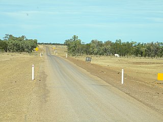
The Outback Highway or Outback Way is a series of roads and dirt tracks linking Winton, Queensland and Laverton, Western Australia. At 2,800 km (1,740 mi), it crosses Central Australia, passing through Queensland, the Northern Territory and Western Australia.

Barkly Highway highway in the Northern Territory and Queensland

The Barkly Highway is a national highway of both Queensland and the Northern Territory.

The Arnhem Highway is a 227—kilometre highway in the Northern Territory of Australia. It links the mining town of Jabiru, in Kakadu National Park, to the Stuart Highway at a point 35 kilometres south of Darwin.

Savannah Way route in Australia

The Savannah Way is a route of highways and major roads across the tropical savannahs of northern Australia, linking Cairns in Queensland with Broome in Western Australia. Promoted as a self-drive tourist route, it joins Cairns, Normanton, Borroloola, Katherine, Kununurra, Fitzroy Crossing, Derby and Broome. It has been designated by the Queensland Government as a State Strategic Touring Route.

Highway 1 (South Australia) road route in South Australia

In South Australia, Highway 1 is a 1,717-kilometre (1,067 mi) long route that follows the coastline of the state, from the Victorian border near Mount Gambier to the Western Australian border near Eucla. Highway 1 continues around the rest of Australia, joining all mainland state capitals, and connecting major centres in Tasmania. All roads within the Highway 1 system are allocated a road route numbered 1, M1, A1, or B1, depending on the state route numbering system, and parts are concurrent with National Highway routes. In South Australia, most of the highway is designated as route A1, with multi-lane, dual-carriage-way sections generally designated route M1. South-east of Tailem Bend, it is designated route B1.

Cox Peninsula Road road in the Northern Territory

The Cox Peninsula Road is a rural road in the Northern Territory of Australia linking the Cox Peninsula and western shore of Darwin Harbour to the Stuart Highway in the rural suburb of Noonamah on the outskirts of Darwin. The route is approximately 80 km (50 mi) and passes through the town of Berry Springs as well as the rural areas of Tumbling Waters and Blackmore heading west, before turning north towards the Indigenous community of Belyuen. The road ends at a junction with Charles Point Road in Wagait Shire, a few kilometres west of Mandorah on the Cox Peninsula.

Dorat Road is a designated state route in the Northern Territory of Australia providing an alternative route to the Stuart Highway from Adelaide River and rejoining north of Hayes Creek, a distance of 65 km (40 mi). The road provides access to tourist attractions including Robin Falls and Douglas-Daly Hot Springs, several World War II heritage locations, and forms part of the road access to Daly River and Wadeye via the Daly River Road which branches from Dorat Road approximately 31 km (19 mi) south of Adelaide River.

Highway 1 (Western Australia) road route in Western Australia

In Western Australia, Highway 1 is a 5,305-kilometre (3,296 mi) long route around the state, from the South Australian border near Eucla to the Northern Territory border near Kununurra. Highway 1 continues around the rest of Australia, joining all mainland state capitals, and connecting major centres in Tasmania. All roads within the Highway 1 system are allocated a road route numbered 1, M1, A1, or B1, depending on the state route numbering system. In Western Australia, most of the highway is designated as National Route 1; however, the sections in the north-east and south-east of the state that are concurrent with the National Highway routes linking Perth to Adelaide and Darwin are designated as National Highway 1.

Highway 1 (Queensland) road route in Queensland

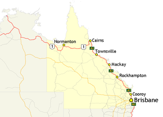
In Queensland, Highway 1 is a 2,964-kilometre (1,842 mi) long route that crosses the state, from the Northern Territory (NT) border near Wollogorang to Cairns, and then travels along the coastline to the New South Wales (NSW) border near Coolangatta. Highway 1 continues around the rest of Australia, joining all mainland state capitals, and connecting major centres in Tasmania. All roads within the Highway 1 system are allocated a road route numbered 1, M1, A1, or B1, depending on the state route numbering system. In Queensland, the highway is designated as National Route 1 from the NT border to Cairns, Route A1 from Cairns to Kybong, and then Route M1 down to the NSW border.

Highway 1 (New South Wales) road route in New South Wales

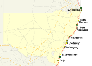
In New South Wales, Highway 1 is a 1,351-kilometre (839 mi) long route that crosses the state, from the Queensland/New South Wales border near Tweed Heads to the Victorian border near Timbillica. It provides the main coastal route between Brisbane and Melbourne via Sydney. Highway 1 continues around the rest of Australia, joining all mainland state capitals, and connecting major centres in Tasmania.

Highway 1 (Tasmania) road route in Tasmania

In Tasmania, Highway 1 is a 336-kilometre (209 mi) long route that connects Hobart to the state's north coast, and to Launceston via a 3.8-kilometre (2.4 mi) long spur. Highway 1 also exists on the mainland of Australia, linking the state capitals via a circular route around the coastline. All roads within the Highway 1 system are allocated a road route numbered 1, M1, A1, or B1, depending on the state route numbering system. In Tasmania the highway is designated as National Highway 1, though all other routes in the state are alphanumeric.

Highway 1 (Victoria) road route in Victoria

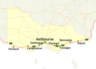
In Victoria, Highway 1 is a 958-kilometre (595 mi) long route that follows the coastline of the state, from the New South Wales border near Genoa to the South Australian border near Dartmoor. Highway 1 continues around the rest of Australia, joining all mainland state capitals, and connecting major centres in Tasmania. All roads within the Highway 1 system are allocated a road route numbered 1, M1, A1, or B1, depending on the state route numbering system. In Victoria, the highway is designated as State Route M1 between Traralgon and Winchelsea, and route A1 elsewhere.

Main Roads Western Australia controls the major roads in the state's Kimberley region. Great Northern Highway is the major road connection through the region, with sealed roads spurring off it to connect to population centres, and unsealed roads offering an alternative route between Derby and Wyndham.

Settlement Creek river in Australia

The Settlement Creek is a creek located in the Northern Territory and the state of Queensland, Australia.

References

  1. Google (19 March 2013). "Highway 1 (Northern Territory) – Western Australia to Queensland" (Map). Google Maps . Google. Retrieved 19 March 2013.
  2. Google (19 March 2013). "Highway 1 (Northern Territory) – Katherine to Darwin" (Map). Google Maps . Google. Retrieved 19 March 2013.
  3. Taylor, David (2012). The Highway One travel companion. Volume 1, Melbourne to Tweed Heads. Salisbury, Queensland: Boolarong Press. p. 9. ISBN   9780987218902.

See also

Route map: Google

KML file (edithelp)
KML is from Wikidata