You can help expand this article with text translated from the corresponding article in Hebrew. Click [show] for important translation instructions.
Machine translation, like DeepL or Google Translate, is a useful starting point for translations, but translators must revise errors as necessary and confirm that the translation is accurate, rather than simply copy-pasting machine-translated text into the English Wikipedia.
Consider adding a topic to this template: there are already 417 articles in the main category, and specifying|topic= will aid in categorization.
Do not translate text that appears unreliable or low-quality. If possible, verify the text with references provided in the foreign-language article.
You must provide copyright attribution in the edit summary accompanying your translation by providing an interlanguage link to the source of your translation. A model attribution edit summary is Content in this edit is translated from the existing Hebrew Wikipedia article at [[:he:כביש 65]]; see its history for attribution.
You should also add the template {{Translated|he|כביש 65}} to the talk page.
This road is the shortest and simplest way to connect these two major regions. Historically, people traveled on or near this route for thousands of years from the coastal plain to reach the Galilee, and beyond it the Golan, Syria, Lebanon, and Jordan (seeVia Maris). In the 1949 Armistice Agreements Israel received the portion of this road in Wadi Ara for this reason.[citation needed]
The road passes by many Arab villages and cities but few Jewish habitations in Nahal Iron. In October 2000, at the beginning of the Second Intifada, the road was blocked by local Palestinian protesters. For security reasons Highway 70, which runs parallel to the north of Highway 65, has been improved.[citation needed]
The northern section of the highway, between Golani and Nahal Amud (nearby Kadarim) is a freeway.
The long term plans are for the entire highway to be converted to a freeway, including a new bypass section just north of Afula. Given the extremely high cost of the overall effort required (estimated at nearly NIS 3.5 billion, equivalent to almost US$1 billion), this will be implemented in phases, with work on the Afula–Golani section expected to be implemented first as it is the only section of the road which still consists of only two lanes. Construction on this section is expected to begin by 2019.[needs update]
The Jordan River or River Jordan, also known as Nahr Al-Sharieat, is a 251-kilometre-long (156 mi) river in the Middle East that flows roughly north to south through the Sea of Galilee and on to the Dead Sea. Jordan and the Golan Heights border the river to the east, while the West Bank and Israel lie to its west. Both Jordan and the West Bank take their names from the river.
The Megiddo Junction is an intersection of Highways 65 and 66 in northern Israel, at the exit from the mountain pass coming up through Wadi Ara into the Jezreel Valley. It is named for the nearby ruins of the biblical city of Megiddo, also known as Armageddon, and the sites of several historic battles. Adjacent to the junction is the large Megiddo Prison, and less than 1 kilometre (0.62 mi) to the northwest is kibbutz Megiddo.
Highway 20, more commonly known as the Ayalon Highway, or simply Ayalon, is a major intracity freeway in Gush Dan, Israel. The road runs along the eastern border of central Tel Aviv from north to south and connects all of the major highways leading to the city—such as Highway 4 from Ashdod and the Southern regions, Highway 2 from Haifa and the Northern regions, Highway 5 from the East, and Highway 1 from Jerusalem and the Southeast. The Ayalon Highway is heavily used; on an average day almost 600,000 vehicles enter the freeway. It consists of a multi-lane highway with a multi-track railway located between the opposite travel lanes. Some of the highway's route is along the Ayalon River, hence its name.
Israeli coastal plain is the coastal plain along Israel's Mediterranean Sea coast, extending 187 kilometres (116 mi) north to south. It is a geographical region defined morphologically by the sea, in terms of topography and soil, and also in its climate, flora and fauna. It is narrow in the north and broadens considerably towards the south, and is continuous, except the short section where Mount Carmel reaches almost all the way to the sea. The Coastal Plain is bordered to the east by – north to south – the topographically higher regions of the Galilee, the low and flat Jezreel Valley, the Carmel range, the mountains of Samaria, the hill country of Judea known as the Shephelah, and the Negev Mountains in the south. To the north it is separated from the coastal plain of Lebanon by the cliffs of Rosh HaNikra, which jut out into the sea from the Galilee mountains, but to the south it continues into the Egyptian Sinai Peninsula.
Highway 1 is the main highway in Israel, connecting Tel Aviv and Jerusalem, and continuing eastwards to the Jordan Valley in the West Bank.
The Menashe Regional Council is a regional council near the city of Hadera, on Israel's north-central coastal plain in the southern Haifa District. It is named after the tribe of Menashe which had been allotted this region according to the Book of Joshua (17:1-10).
Binyamina railway station is an Israel Railways passenger station located in the region of Binyamina-Giv'at Ada and serves these towns, as well as Zikhron Ya'akov, Or Akiva and other small communities in the area.
Highway 2 is an Israeli highway located on the coastal plain of the Mediterranean Sea. It begins as a major arterial road within Tel Aviv, becoming a freeway as it exits the city northward continuing to Haifa. North of Tel Aviv, the highway is also called The Coastal Highway.
Highway 4 is an Israeli highway that runs along Israel's entire coastal plain of the Mediterranean Sea, from the Rosh HaNikra border crossing with Lebanon in the North to the Erez Border Crossing with the Gaza Strip in the South. The highway follows in part the route of the ancient Via Maris.
Wadi Ara or Nahal 'Iron, is a valley and its surrounding area in Israel populated mainly by Arab Israelis. The area is also known as the "Northern Triangle".
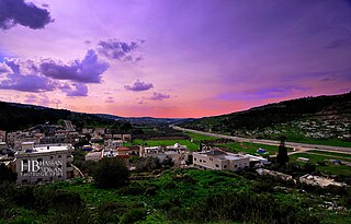
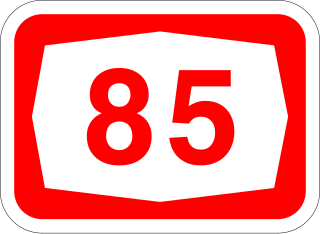
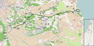
Highway 85 is an east-west highway in Northern Israel. It is one of the most important roads through the Galilee, connecting the western Galilee with the Eastern Galilee. The road begins in Akko on the west coast of Israel and ends in the east just north of Lake Kinneret.
The Jezreel Valley railway, or the Valley Train was a railroad that existed in Ottoman and British Palestine, reconstituted as a modern railway in Israel in the 21st century. It runs from the Mediterranean coast inland along the length of the Jezreel Valley. The historical line was a segment of the longer Haifa–Dera'a Line, which was itself a branch of the larger Hejaz railway.
Hadera Stream, known in Arabic as Nahr Mufjir and previously also as Nahr Akhdar, is a seasonal watercourse in Israel.
Highway 70 is a highway, 76 km in length, running through the Western Galilee region in the Northern District of Israel. It connects the Mount Carmel region east of Zikhron Ya'akov to the Lower Galilee, Kiryat Ata, and Shlomi near Israel's border with Lebanon. The highway runs concurrently with Highway 6 for 2.5 km between Ein Tut Interchange and Elyakim Interchange and for 4 km between Tel Qashish and Ha'Amakim Interchange, then with Highway 75 for 4 km between Ha'Amakim Interchange and Yagur Junction, then again with Highway 6 for 5 km between Givot Alonim Interchange and Somekh Interchange.
Highway 77 is an east-west highway in northern Israel. It crosses the Lower Galilee in the region of the Beit Netofa Valley. The road leads from the Tel Qashish Interchange nearby Yokneam Illit to Tiberias. It is 48 km long. Its western section, from the Tel Qashish Interchange to the Golani Interchange is a freeway.
Route 531, is a suburban freeway in the southern Sharon region of Israel, just north of the Tel Aviv Metropolitan Area. The highway begins at Highway 6 and terminates at the Ayalon Highway with an extension to the Coastal Highway.
Nahal Amud, also known as the Wadi al-Amud, is a stream in the Upper Galilee region of Israel that flows into the Sea of Galilee.
The Eastern Railway refers to a railroad in central Israel stretching from Lod to Hadera. The section between Kfar Saba and Lod, as well as a short section just north of Hadera are currently in use but the rest of the railway has not been operative since 1969. However, in 2019 a large-scale project began to rebuild and upgrade the railway along the entire route.
The Road of the Patriarchs or Way of the Patriarchs, is an ancient north–south route traversing the land of Israel. The name is used by biblical scholars because of mentions in biblical narratives that it was frequently travelled by Abraham, Isaac and Jacob.
Hadera East railway station is a former railway station in Hadera, Israel. It originally served as the northern terminus of the Eastern Railway. In 1968, the line was closed to passengers and the railway south of the station to Kfar Saba was abandoned. A short section of the Eastern Railway connecting the station north to the Coastal railway line was left in operation—being used by freight trains serving the Granot "Ambar North" large feed mill complex near Gan Shmuel that is located adjacent to Hadera East station.
This page is based on this Wikipedia article Text is available under the CC BY-SA 4.0 license; additional terms may apply. Images, videos and audio are available under their respective licenses.