Holland (CDP), New York

Last updated • 2 min readFrom Wikipedia, The Free Encyclopedia
Holland, New York
North Main Street, Holland, New York - 20210610.jpg
View along North Main Street in the town center, as seen in June 2021
Erie County New York incorporated and unincorporated areas Holland (CDP) highlighted.svg
Location in Erie County and the state of New York
Coordinates: 42°38′29″N78°32′36″W / 42.64139°N 78.54333°W / 42.64139; -78.54333 Coordinates: 42°38′29″N78°32′36″W / 42.64139°N 78.54333°W / 42.64139; -78.54333
Country United States
State New York
County Erie
Town Holland
Area
[1]
  Total4.00 sq mi (10.37 km2)
  Land4.00 sq mi (10.37 km2)
  Water0.00 sq mi (0.00 km2)
Elevation
1,106 ft (337 m)
Population
 (2020)
  Total1,173
  Density292.96/sq mi (113.11/km2)
Time zone UTC-5 (Eastern (EST))
  Summer (DST) UTC-4 (EDT)
ZIP code
14080
Area code 716
FIPS code 36-35111
GNIS feature ID0952987

Holland is a hamlet and census-designated place (CDP) in Erie County, New York, United States. The population was 1,206 at the 2010 census. It is in the town of Holland and is part of the Buffalo Niagara Falls Metropolitan Statistical Area.

Contents

Geography

Holland is located at 42°38′28″N78°32′36″W / 42.64111°N 78.54333°W / 42.64111; -78.54333 (42.641305, -78.543367). [2]

According to the United States Census Bureau, the CDP has a total area of 3.6 square miles (9.2 km2), all land.

Demographics

Historical population
CensusPop.
2020 1,173
U.S. Decennial Census [3]

As of the census [4] of 2000, there were 1,261 people, 488 households, and 328 families living in the CDP. The population density was 354.7 per square mile (136.8/km2). There were 507 housing units at an average density of 142.6/sq mi (55.0/km2). The racial makeup of the CDP was 98.10% White, 0.63% Black or African American, 0.08% Native American, 0.48% Asian, 0.08% from other races, and 0.63% from two or more races. Hispanic or Latino of any race were 0.32% of the population.

There were 488 households, out of which 34.0% had children under the age of 18 living with them, 54.3% were married couples living together, 10.2% had a female householder with no husband present, and 32.6% were non-families. 27.0% of all households were made up of individuals, and 13.3% had someone living alone who was 65 years of age or older. The average household size was 2.58 and the average family size was 3.19.

In the CDP, the population was spread out, with 27.1% under the age of 18, 7.5% from 18 to 24, 30.1% from 25 to 44, 22.1% from 45 to 64, and 13.1% who were 65 years of age or older. The median age was 37 years. For every 100 females, there were 96.4 males. For every 100 females age 18 and over, there were 95.5 males.

The median income for a household in the CDP was $39,702, and the median income for a family was $56,806. Males had a median income of $40,250 versus $25,461 for females. The per capita income for the CDP was $18,721. About 7.5% of families and 10.2% of the population were below the poverty line, including 11.6% of those under age 18 and 14.6% of those age 65 or over.

Related Research Articles

<span class="mw-page-title-main">North Weeki Wachee, Florida</span> Census-designated place in Florida, United States

North Weeki Wachee is a census-designated place (CDP) in Hernando County, Florida, United States. The population was 8,524 at the 2010 census, up from 4,253 at the 2000 census.

<span class="mw-page-title-main">Billington Heights, New York</span> Census-designated place in New York, United States

Billington Heights is a hamlet and census-designated place (CDP) in the towns of Elma and Aurora in Erie County, New York, United States. The population was 1,685 at the 2010 census. It is part of the Buffalo–Niagara Falls Metropolitan Statistical Area.

<span class="mw-page-title-main">Elma Center, New York</span> Census-designated place in New York, United States

Elma Center is a hamlet and census-designated place (CDP) in the town of Elma in Erie County, New York, United States. As of the 2010 census, this community population was 2,571. It is part of the Buffalo–Niagara Falls Metropolitan Statistical Area.

<span class="mw-page-title-main">North Boston, New York</span> Census-designated place in New York, United States

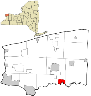
North Boston is a hamlet and census-designated place (CDP) in the town of Boston in Erie County, New York, United States. As of the 2010 census, the CDP population was 2,521. It is part of the Buffalo–Niagara Falls Metropolitan Statistical Area.

<span class="mw-page-title-main">Rapids, New York</span> CDP in New York, United States

Rapids is a hamlet located in the Town of Lockport in Niagara County, New York, United States. The population was 1,636 at the 2010 census. The ZIP code for Rapids is 14094.

<span class="mw-page-title-main">Gilgo-Oak Beach-Captree, New York</span> Census-designated place in New York, United States

Gilgo-Oak Beach-Captree, frequently just called Oak Beach, was a census-designated place (CDP) in Suffolk County, New York within the Town of Babylon. The population was 333 at the 2000 census.

<span class="mw-page-title-main">Dennis, Oklahoma</span> Census-designated place in Oklahoma, United States

Dennis is an unincorporated community and census-designated place (CDP) in Delaware County, Oklahoma, near Grand Lake. The population was 195 at the 2010 census. The Dennis Post Office existed from March 25, 1914, until January 31, 1956. It is said to be named for a local resident, Peter Dennis.

<span class="mw-page-title-main">Vinco, Pennsylvania</span> Census-designated place in Pennsylvania, United States

Vinco is an unincorporated community and census-designated place (CDP) in Jackson Township, Cambria County, in the U.S. state of Pennsylvania. The population was 1,305 at the 2010 census.

<span class="mw-page-title-main">Plymptonville, Pennsylvania</span> Census-designated place in Pennsylvania, United States

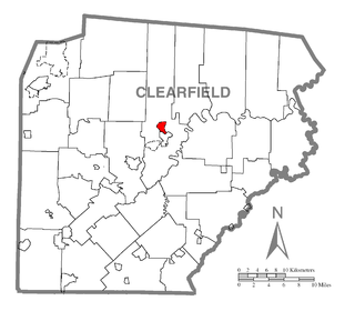
Plymptonville is a census-designated place (CDP) in Clearfield County, Pennsylvania, United States. The population was 972 at the 2020 census.

<span class="mw-page-title-main">Sandy, Pennsylvania</span> Census-designated place in Pennsylvania, United States

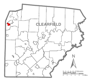
Sandy is a census-designated place (CDP) in Clearfield County, Pennsylvania, United States. The population was 1,429 at the 2010 census.

<span class="mw-page-title-main">Mexico, Juniata County, Pennsylvania</span> Census-designated place in Pennsylvania, United States

Mexico is an unincorporated community and census-designated place (CDP) in Walker Township, Juniata County, Pennsylvania, United States. The population was 472 at the 2010 census.

Yeagertown is a census-designated place (CDP) in Mifflin County, Pennsylvania, United States. The population was 1,035 at the 2000 census.

Cane Savannah is a census-designated place (CDP) in Sumter County, South Carolina, United States. The population was 1,452 at the 2000 census. It is included in the Sumter, South Carolina Metropolitan Statistical Area.

<span class="mw-page-title-main">Chester (CDP), Vermont</span> Census-designated place in Vermont, United States

Chester is a census-designated place (CDP) in Windsor County, Vermont, United States. The population was 1,005 at the 2010 census. The CDP is a statistical area encompassing three distinct places: the urbanized center of the town of Chester; a locale known as Chester Depot, which is separated from the town center by the tracks of the former Rutland Railroad; and the village of North Chester.

Northeast Itasca is an unorganized territory in Itasca County, Minnesota, United States. The population was 1,179 at the 2010 census.

<span class="mw-page-title-main">Andover (CDP), Massachusetts</span> Census-designated place in Massachusetts, United States

Andover is a census-designated place (CDP) in the town of Andover in Essex County, Massachusetts, United States. The population was 8,762 at the 2010 census.

<span class="mw-page-title-main">Cheektowaga (CDP), New York</span> Census-designated place in New York, United States

Cheektowaga is a suburban community and census-designated place (CDP) in Erie County, New York, United States. The population was 75,178 at the 2010 census, making it the most populous census-designated place in New York. It is within the town of Cheektowaga. The CDP includes Buffalo Niagara International Airport.

<span class="mw-page-title-main">Eden (CDP), New York</span> Census-designated place in New York, United States

Eden is a hamlet and census-designated place (CDP) in Erie County, New York, United States. The population was 3,516 at the 2010 census. It is part of the Buffalo–Niagara Falls Metropolitan Statistical Area.

<span class="mw-page-title-main">Tonawanda (CDP), New York</span> Census-designated place in New York, United States

Tonawanda is a census-designated place (CDP) in Erie County, New York, United States. The CDP comprises the town of Tonawanda minus its subsidiary village of Kenmore. As of the 2010 census, the CDP population was 58,144.

<span class="mw-page-title-main">Alloway (CDP), New Jersey</span> Census-designated place in New Jersey, United States

Alloway is an unincorporated community and census-designated place (CDP) located within Alloway Township, in Salem County, New Jersey, United States. As of the 2010 United States Census, the CDP's population was 1,402.

References

  1. "ArcGIS REST Services Directory". United States Census Bureau. Retrieved September 20, 2022.
  2. "US Gazetteer files: 2010, 2000, and 1990". United States Census Bureau. 2011-02-12. Retrieved 2011-04-23.
  3. "Census of Population and Housing". Census.gov. Retrieved June 4, 2016.
  4. "U.S. Census website". United States Census Bureau . Retrieved 2008-01-31.