Horton, Berkshire

Last updated

Horton
Village and civil parish
St Michael the Archangel in Horton Berkshire.jpg
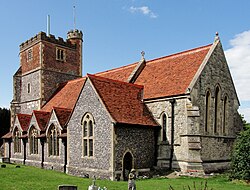
St Michael and All Angels parish church
Berkshire UK location map.svg
Red pog.svg
Horton
Location within Berkshire
Population983 
2001 United Kingdom census [1]
1,033 (2011 Census) [2]
OS grid reference TQ0175
Civil parish
  • Horton
Unitary authority
Ceremonial county
Region
Country England
Sovereign state United Kingdom
Post town Slough
Postcode district SL3
Dialling code 01753
Police Thames Valley
Fire Royal Berkshire
Ambulance South Central
UK Parliament
List of places
UK
England
Berkshire
51°28′23″N0°32′35″W / 51.473°N 0.543°W / 51.473; -0.543 Coordinates: 51°28′23″N0°32′35″W / 51.473°N 0.543°W / 51.473; -0.543

Horton is a village and civil parish in Berkshire, England. It is between Windsor and Staines-upon-Thames.

Contents

History and etymology

The village name is a common one in England. It is Old English in origin and derives from the two words horu 'dirt' and tūn 'settlement, farm, estate', presumably meaning 'farm on muddy soil'. [3] In the Domesday Book of 1086 it was recorded as Hortune. [3] [4] The Horton Manor was assessed at 10 hides and held by Walter son of Other.

Geography

Through the Horton parish flows the Colne Brook which runs to the River Thames from the River Colne. [5] Wraysbury railway station is nearest to its southern end, and Sunnymeads railway station is nearest to its western end. Heathrow Airport is to its east. [6] Horton has a local nature reserve, the Arthur Jacob Nature Reserve. [7]

Parish church

The Church of England parish church of St Michael has a 12th-century nave, [8] with an ornate Norman arch over the north door in the porch. [9] The north transept is 15th century [8] and the square bell-tower is late 16th century. [9] The aisle, chancel and vestry were rebuilt in 1875–76. [5] [8] The exterior of the church is chequered with brickwork, limestone and flint. The tower is square and between 70 and 80 feet (21 and 24 m) high. [3] [4] It has a clock, and the ring of bells was augmented from five to six in 1987.[ citation needed ]

Governance

Horton was transferred from Buckinghamshire to Berkshire in 1974. At parish level the village is represented by nine councillors of the Horton Parish Council. [10] At borough level the town is part of the Datchet Horton and Wraysbury electoral ward and is currently represented by three councillors, David Cannon (Conservative), Ewan Larcombe (independent) and Gary Muir (Conservative), in the Royal Borough of Windsor and Maidenhead. [11] Nationally, since 1997 the ward has formed part of the UK Parliamentary constituency of Windsor, which has been represented since 2005 by Adam Afriyie of the Conservative Party. Before 1997 the town was part of the UK Parliamentary constituency of Windsor and Maidenhead which was consistently held by the Conservative Party.

Notable residents

John Milton the English poet is one of the more famous former residents of Horton. [3] [4] [12] His family rented Berkyn Manor, a house that belonged to Sir John Egerton, in the parish between 1632 and 1640. The chancel of St Michael's parish church contains the grave of Milton's mother Sara; and a 19th-century stained glass window on the church commemorates Milton's poem Paradise Lost. The current Berkyn Manor was rebuilt in 1848 by Edward Tyrrell (Remembrancer of the City of London) reputedly on the site of Milton's house.

Related Research Articles

<span class="mw-page-title-main">Staines-upon-Thames</span> Town in Surrey, England

Staines-upon-Thames is a market town in northwest Surrey, England, around 17 mi (27 km) west of central London. It is in the Borough of Spelthorne, at the confluence of the River Thames and Colne. Historically part of Middlesex, the town was transferred to Surrey in 1965. Staines is close to Heathrow Airport and is linked to the national motorway network by the M25 and M3.

<span class="mw-page-title-main">Colnbrook</span> Human settlement in England

Colnbrook is a village in the Slough district in Berkshire, England. It lies within the historic boundaries of Buckinghamshire, and straddles two distributaries of the Colne, the Colne Brook and Wraysbury River. These two streams have their confluence just to the southeast of the village. Colnbrook is centred 3 miles (4.8 km) southeast of Slough town centre, 3.5 miles (5.6 km) east of Windsor, and 19 miles (31 km) west of central London.

<span class="mw-page-title-main">Maidenhead</span> Human settlement in England

Maidenhead is a market town in the Royal Borough of Windsor and Maidenhead in the county of Berkshire, England, on the southwestern bank of the River Thames. It had an estimated population of 70,374 and forms part of the border with southern Buckinghamshire. The town is situated 27 miles (43 km) west of Charing Cross, London and 13 miles (21 km) east-northeast of the county town of Reading. The town differs from the Parliamentary constituency of Maidenhead, which includes a number of outer suburbs and villages such as Twyford, Charvil, Remenham, Ruscombe and Wargrave.

<span class="mw-page-title-main">Royal Borough of Windsor and Maidenhead</span> Borough and unitary authority in Berkshire, England

The Royal Borough of Windsor and Maidenhead is a Royal Borough of Berkshire, in South East England. It is named after both the towns of Maidenhead and Windsor, the borough also covers the nearby towns of Ascot and Eton. It is home to Windsor Castle, Eton College, Legoland Windsor and Ascot Racecourse. It is one of four boroughs entitled to be prefixed Royal and is one of six unitary authorities in the county, which has historic and ceremonial status.

<span class="mw-page-title-main">Wraysbury</span> Human settlement in England

Wraysbury is a village and civil parish in the Royal Borough of Windsor and Maidenhead in England. It is under the western approach path of London Heathrow Airport. It is located on the east bank of the River Thames, roughly midway between Windsor and Staines-upon-Thames, and 18 miles (29 km) west by south-west of London. Historically part of Buckinghamshire, Wraysbury was made part of the new non-metropolitan county of Berkshire in 1974, under the Local Government Act 1972. The Wraysbury Reservoir is located to the east, administratively wholly in the Spelthorne district of Surrey, although it was historically divided between Buckinghamshire and Middlesex.

<span class="mw-page-title-main">Windsor, Berkshire</span> Market town in Berkshire, England

Windsor is a historic market town and unparished area in the Royal Borough of Windsor and Maidenhead in Berkshire, England. It is the site of Windsor Castle, one of the official residences of the British monarch. The town is situated 21.8 miles (35.1 km) west of Charing Cross, central London, 5.8 miles (9.3 km) southeast of Maidenhead, and 15.8 miles (25.4 km) east of the county town of Reading. It is immediately south of the River Thames, which forms its boundary with its smaller, ancient twin town of Eton. The village of Old Windsor, just over 2 miles (3 km) to the south, predates what is now called Windsor by around 300 years; in the past Windsor was formally referred to as New Windsor to distinguish the two.

<span class="mw-page-title-main">Eton, Berkshire</span> Town in Berkshire, England

Eton is a town in Berkshire, England, on the opposite bank of the River Thames to Windsor, connected to it by Windsor Bridge. The civil parish, which also includes the village of Eton Wick two miles west of the town, had a population of 4,692 at the 2011 Census. Within the boundaries of the historic county of Buckinghamshire, in 1974 it became part of the Berkshire admin area following the Local Government Act 1972; since 1998 it has been part of the unitary authority of Windsor and Maidenhead. The town is best known as the location of Eton College.

<span class="mw-page-title-main">Borough of Spelthorne</span> Place in England

Spelthorne is a local government district and borough in Surrey, England. Its council is based in Staines-upon-Thames; other settlements in the area include Ashford, Sunbury-on-Thames, Shepperton, Stanwell and Laleham.

<span class="mw-page-title-main">Ashford, Surrey</span> Human settlement in England

Ashford is a town in Surrey, England, 14 mi (23 km) west of central London. Its name derives from a crossing point of the River Ash, a distributary of the River Colne. Historically part of Middlesex, the town has been part of Surrey since 1965. Ashford consists of relatively low density low- and medium-rise buildings, none of them being high rise. If excluding apartments most houses are semi-detached.

<span class="mw-page-title-main">Bray, Berkshire</span> Village in Berkshire, England

Bray, occasionally Bray on Thames, is a suburban village and civil parish in the English county of Berkshire. It sits on the banks of the River Thames, to the southeast of Maidenhead of which it is a suburb. The village is mentioned in the comedic song "The Vicar of Bray". Bray contains two of the eight three-Michelin-starred restaurants in the United Kingdom and has several large business premises including Bray Studios at Water Oakley, where the first series of Hammer Horror films were produced.

<span class="mw-page-title-main">Windsor (UK Parliament constituency)</span> UK Parliament constituency

Windsor (/ˈwɪnzə/) is a constituency in Berkshire represented in the House of Commons of the UK Parliament since 2005 by Adam Afriyie of the Conservative Party. It was re-created for the 1997 general election after it was abolished following the 1970 general election and replaced by the Windsor and Maidenhead constituency.

<span class="mw-page-title-main">Cookham</span> Village in Berkshire, England

Cookham is a historic Thames-side village and civil parish on the north-eastern edge of Berkshire, England, 2.9 miles (5 km) north-north-east of Maidenhead and opposite the village of Bourne End. Cookham forms the southernmost and most rural part of the High Wycombe urban area. With adjoining Cookham Rise and Cookham Dean, it had a combined population of 5,779 at the 2011 Census. In 2011, The Daily Telegraph deemed Cookham Britain's second richest village.

Clewer is an ecclesiastical parish and an area of Windsor in the county of Berkshire, England. Clewer makes up three wards of the Royal Borough of Windsor and Maidenhead, namely Clewer North, Clewer South and Clewer East.

<span class="mw-page-title-main">East Berkshire (UK Parliament constituency)</span>

East Berkshire was a county constituency in the county of Berkshire. It returned one Member of Parliament (MP) to the House of Commons of the Parliament of the United Kingdom, elected by the first past the post voting system.

The Colne Brook is a river in England that is a distributary of the River Colne which runs from Uxbridge Moor, there forming the western border of Greater London, to the River Thames just below Bell Weir Lock in Hythe End, Wraysbury, Berkshire.

<span class="mw-page-title-main">St Mary's, Staines</span> Church in United Kingdom

St Mary's, Staines, is a Church of England parish church in the town and parish of Staines-upon-Thames, in the Spelthorne borough of Surrey and the Greater London Urban Area. The parish is in the Archdeaconry of Middlesex in the Diocese of London. The church building is on an unusual rise against the Thames at the west end of the town. It has been a Grade II* listed building since 11 August 1952.

Horton and Wraysbury is an electoral ward represented by two councillors in the Royal Borough of Windsor and Maidenhead. Nationally, the ward forms part of the UK Parliamentary constituency of Windsor and is represented by Adam Afriyie of the Conservative Party.

The 2015 Windsor and Maidenhead Borough Council election took place on 7 May 2015 to elect all members of the council of the Royal Borough of Windsor and Maidenhead in England. This was on the same day as other local elections and coincided with the 2015 United Kingdom general election.

References

  1. "Parish Headcounts : Windsor and Maidenhead". Census 2001. Office for National Statistics.
  2. "Civil Parish population 2011". Neighbourhood Statistics. Office for National Statistics. Retrieved 30 November 2016.
  3. 1 2 3 4 Watts, Victor, ed. (2004). The Cambridge Dictionary of English Place-Names, Based on the Collections of the English Place-Name Society. Cambridge: Cambridge University Press.
  4. 1 2 3 Gyll, G.W.J. (1862). History of the Parish of Wraysbury, Ankerwycke Priory, and Magna Charta Island; with the History of Horton, and the town of Colnbrook, Bucks. London: H. G. Bohn. online version at Google Books: OCLC: 5001532
  5. 1 2 Page, William H, ed. (1925). "Horton". A History of the County of Buckingham, Volume 3. pp. 281–286.
  6. "Amenities". Archived from the original on 18 August 2018. Retrieved 18 August 2018.
  7. "Magic Map Application". Magic.defra.gov.uk. Retrieved 8 May 2017.
  8. 1 2 3 Historic England. "Church of St Michael, Stanwell Road (1117644)". National Heritage List for England . Retrieved 28 May 2013.
  9. 1 2 Pevsner, Nikolaus (1966). Berkshire. The Buildings of England. Harmondsworth: Penguin Books. p. 171.
  10. "homepage". Horton Parish Council. 8 April 2012. Archived from the original on 15 March 2012.
  11. "Horton and Wraysbury Ward". Councillors. Royal Borough of Windsor and Maidenhead. 1 February 2013. Archived from the original on 21 July 2011.
  12. Masson, David (1859). The life of John Milton: narrated in connexion with the political, ecclesiastical, and literary history of his time. Vol. 1. Boston: Gould and Lincoln.