
Windermere is a town and civil parish in the South Lakeland District of Cumbria, England. In the 2001 census the parish had a population of 8,245, increasing at the 2011 census to 8,359. It lies about half a mile (1 km) east of the lake, Windermere. Although the town Windermere does not touch the lake, it has now grown together with the older lakeside town of Bowness-on-Windermere, though the two retain distinguishable town centres. Tourism is popular in the town owing to its proximity to the lake and local scenery. Boats from the piers in Bowness sail around the lake, many calling at Ambleside or at Lakeside where there is a restored railway. Windermere Hotel opened at the same time as the railway.
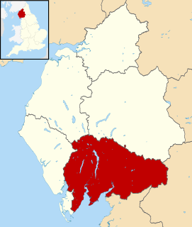
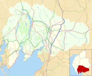
South Lakeland is a local government district in Cumbria, England. The population of the non-metropolitan district was 102,301 according to the 2001 census, increasing to 103,658 at the 2011 Census. Its council is based in Kendal. It includes much of the Lake District as well as northwestern parts of the Yorkshire Dales.
Arnside is a village and civil parish in Cumbria, historically part of Westmorland, near the border with Lancashire, England. The Lake District National Park is located a few miles North. Travelling by road, Arnside is 22 miles (35 km) to the south of Kendal, 25.3 miles (40.7 km) to the east of Ulverston, 35.2 miles (56.6 km) to the east of Barrow-in-Furness, 15.7 miles (25.3 km) to the west of Lancaster and 14.3 miles (23.0 km) to the east of Grange-over-Sands. In the 2001 census the parish had a population of 2,301, increasing at the 2011 census to 2,334.

Grayrigg is a small village and civil parish in the South Lakeland district of Cumbria, England. In the 2001 census the parish had a population of 223, decreasing at the 2011 census to 242. It lies on undulated and partly mountainous land, 4.9 miles (8 km) north east of Kendal, on the north side of the West Coast Main Line, and west side of the M6 motorway.

Lakes is a large civil parish in the South Lakeland district of Cumbria, England. In the 2001 census the parish had a population of 5,127, decreasing at the 2011 census to 4,420. It covers the small town of Ambleside, and the villages and hamlets of Clappersgate, Rydal, Grasmere, Troutbeck, Chapel Stile, Elterwater, Little Langdale and Waterhead.

Aldingham is a village and civil parish in the South Lakeland district of Cumbria, England. Historically in Lancashire, it is situated on the east coast of the Furness peninsula, facing into Morecambe Bay, and is about 8 miles (13 km) east of Barrow-in-Furness, and 6 miles (9.7 km) south of Ulverston. The parish includes the nearby villages of Baycliff, Dendron, Leece, Gleaston, Newbiggin, Roosebeck, Scales and a number of smaller hamlets. According to the 2001 census the parish had a population of 1,187, reducing to 1,105 at the 2011 Census.

Ravenstonedale is a village and large civil parish in Cumbria, on the watershed between the River Lune and River Eden. The village lies 4 miles (6 km) south west of Kirkby Stephen. The parish includes the village of Newbiggin-on-Lune and several smaller settlements including Bowderdale, Brownber, Greenside, Stennerskeugh, Wath and Weasdale. Large areas of moorland lie within the parish, extending 5 miles (8 km) south west of the village to the northern side of the Howgill Fells. The parish had a population of 570 in 2001, increasing to 594 at the 2011 Census.

Mungrisdale is a small village and civil parish in the north east of the English Lake District in Cumbria. It is also the name of the valley in which the village sits. Mungrisdale is a popular starting point for ascents of the nearby hills, such as Bowscale Fell, Bannerdale Crags and Souther Fell. It lies on the River Glenderamackin, a tributary of the Greta.

Sedgwick is a village and civil parish in Cumbria, England, 4.5 miles (7.2 km) south of Kendal. In the 2001 census the parish had a population of 380, decreasing at the 2011 census to 349.

Underbarrow is a small village in Cumbria, England, located 3 miles (4.8 km) west of Kendal. The village is in the Lake District National Park. It is in the civil parish of Underbarrow and Bradleyfield, in South Lakeland district, and has a parish council. In the 2001 census Underbarrow and Bradleyfield had a population of 351, decreasing at the 2011 census to 330.

Lupton is a linear village and civil parish in the South Lakeland district of Cumbria, England, along the main A65 road north west of Kirkby Lonsdale, 2.3 miles (3.7 km) from the village of Hutton Roof. In the 2001 census the parish had a population of 165, decreasing slightly at the 2011 census to 162.

Cartmel Fell is a hamlet and a civil parish in the South Lakeland district of Cumbria, England. In the 2001 census the parish had a population of 309, increasing at the 2011 census to 329. The village of Cartmel and Cartmel Priory are not in this parish but in Lower Allithwaite, to the south: Cartmel Fell church is about 7 miles north of Cartmel Priory.
Meathop and Ulpha is a former civil parish, now in the parish of Witherslack, Meathop and Ulpha, in the South Lakeland district of the English county of Cumbria. Historically in Westmorland, it is located 3.6 miles (5.8 km) north east of Grange-over-Sands, 10.6 miles (17.1 km) south west of Kendal and 64.0 miles (103.0 km) south of Carlisle, between the confluence of the River Kent estuary and the River Winster. In 2001 it had a population of 143, increasing slightly to 154 at the Census 2011. It included the village of Meathop.

Witherslack is a small village and former civil parish, now in the parish of Witherslack, Meathop and Ulpha, in the south of Cumbria. It lies on the north eastern side of Morecambe Bay, England. The eastern side of the village borders Whitbarrow Scar with Yewbarrow, which is a small limestone hill, located in the centre of the village.

Killington is a village and civil parish in the South Lakeland district of the county of Cumbria, England. It had a population of 152 in 2001, At the 2011 census Killington was grouped with Firbank giving a total population of 261.

Egton with Newland, sometimes written as "Egton-with-Newland", is a civil parish in the South Lakeland district of the English county of Cumbria. It includes the villages of Greenodd and Penny Bridge, and the hamlets of Arrad Foot, Newland and Newland Bottom. In the 2001 census the parish had a population of 898, decreasing at the 2011 census to 817.

Staveley-in-Cartmel is a small village and civil parish in South Lakeland district, Cumbria, England. It lies east of Newby Bridge, near the south end of Windermere, 9 miles (14 km) northeast of Ulverston. It is sometimes known as Staveley-in-Furness. Both names distinguish it from another Staveley in Cumbria. In the 2001 census the parish had a population of 428, decreasing at the 2011 census to 405.

Old Hutton is a village in South Lakeland, Cumbria, England. It is in the civil parish of Old Hutton and Holmescales. In the 2001 census the parish had a population of 357, increasing at the 2011 census to 417.
Nether Staveley is a civil parish in South Lakeland, Cumbria, England. The parish comprises the part of the village of Staveley south of the River Gowan and River Kent, and areas of farmland south of the village. In the 2001 census the parish had a population of 677, increasing at the 2011 census to 710.

Witherslack, Meathop and Ulpha is a civil parish in the South Lakeland district of the English county of Cumbria. Historically in Westmorland, it is located 3.6 miles (5.8 km) north east of Grange-over-Sands and 10.6 miles (17.1 km) south west of Kendal, between the confluence of the River Kent estuary and the River Winster. It was created following the amalgamation of former civil parishes Witherslack and Meathop and Ulpha on 1 April 2015. In 2011 there was a total population of 653. It includes the villages of Witherslack and Meathop.

