The Cheney Brothers Historic District was a center of the silk industry in the late 19th and early 20th century. The 175-acre (71 ha) district in Manchester, Connecticut includes over 275 mill buildings, workers houses, churches, schools and Cheney family mansions. These structures represent the well-preserved company town of the Cheney Brothers silk manufacturing company, the first America-based silk company to properly raise and process silkworms, and to develop the difficult techniques of spinning and weaving silk. The area was declared a National Historic Landmark in 1978.

The John Rider House is located on Main Street in Danbury, Connecticut, United States. It is a wooden frame house dating to the late 18th century.

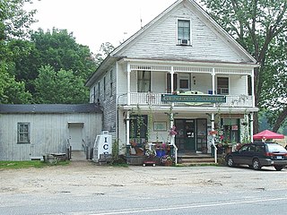
The Talcottville Historic District is a historic district in the town of Vernon, Connecticut. Centered on Elm Hill Road and Main Street, it encompasses a 19th-century mill village, including archaeological remnants of very early cotton-spinning facilities, and old stone dam, and a major wood-frame mill constructed by the Talcott brothers. Also included in the village are a significant number of mill worker housing units, many dating to the middle decades of the 19th century, and an 1891 lenticular pony truss bridge, built by the Berlin Iron Bridge Company. The district was listed on the National Register of Historic Places in 1989.

The Glastonbury-Rocky Hill Ferry Historic District is a historic district in Glastonbury and Rocky Hill, Connecticut, encompassing a landscape with more than 300 years of colonial and post-colonial history. It includes the ferry landings and water traversed by the Rocky Hill – Glastonbury Ferry, one of the longest-running ferry services the nation, and the surrounding farmscapes and ferry landing village. The district was listed on the National Register of Historic Places in 2005.

The South Glastonbury Historic District is a historic district in Glastonbury, Connecticut. It encompasses the historic village center of South Glastonbury, which was first settled in the 17th century. The district was listed on the National Register of Historic Places in 1984, and enlarged in 2009 to include properties further along Main Street as far as Chestnut Hill Road. Locals refer to it as Nayaug.

The Strickland Road Historic District of Greenwich, Connecticut is a 9-acre (3.6 ha) historic district that was listed on the U.S. National Register of Historic Places in 1990. The district extends along Strickland Road in the Cos Cob section of Greenwich, between its junction River Road in the south, to just north of its junction with Loughlin Road in the north. It represents a well-preserved cross-section of residential architecture dating coverint a 200-year period, from about 1740 to 1934. It includes the c. 1730 Bush-Holley House, a historic house museum which is a National Historic Landmark for it role in the Cos Cob art colony. There are 28 primary contributing buildings in the district. Most of the buildings are wood frame structures between one and three stories in height; the notable exceptions are two of the later houses, which are Tudor Revival in style and have brick and stucco exteriors.

The Renwick Building is located in downtown Davenport, Iowa, United States. It has been listed on the National Register of Historic Places since 1983, and on the Davenport Register of Historic Properties since 2000. It is known locally for the large painted sign on the north side of the building depicting the Bix 7 Road Race.
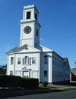
The Mansfield Center Historic District encompasses the historic early village center of Mansfield, Connecticut. First settled about 1692, it is one of the oldest settlements in Tolland County, and retains a strong sense of 18th century colonial layout. It extends along Storrs Street extending from Chaffeeville Road in the north to Centre Street in the south, and was listed on the National Register of Historic Places in 1972.

The Captain Benjamin Williams House, also known as deKoven House or DeKoven Community Center, is a historic house at 27 Washington Street in Middletown, Connecticut. Now owned and operated by the Rockfall Foundation, it was listed on the National Register of Historic Places in 1978.

The Glastonbury Historic District encompasses a streetscape dating to the 17th century, along Main St. from Hebron Ave. to Talcott Rd. in Glastonbury, Connecticut. In addition to a significant number of 17th and 18th-century houses, it shows the architectural development of the town over time, with buildings spanning three centuries in construction dates. It was listed on the National Register of Historic Places in 1984.

The Charlestown Main Street Historic District encompasses the historic heart of Charlestown, New Hampshire. It is located along Main Street, roughly between Lower Landing Road and Bridge Street, and encapsulates more than two hundred years of the town's history. The district was listed on the National Register of Historic Places in 1987.
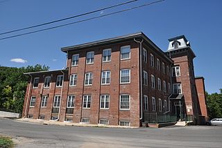
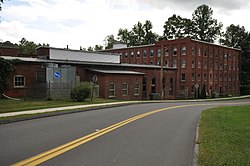
The Gilbert Clock Factory is a historic factory complex at 13 Wallens Street in Winchester, Connecticut. Developed between 1871 and 1897, its surviving elements are a preservation of the state's history as a center for the manufacture of low-cost clocks. The company was one of the town's largest employers for many years. The surviving buildings were listed on the National Register of Historic Places in 1984; they are now house apartments.
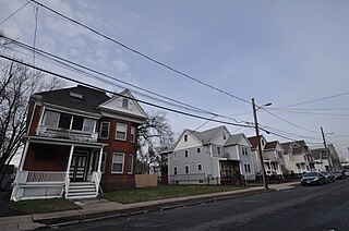
The Allen Place–Lincoln Street Historic District encompasses a small neighborhood of late 19th-century housing built for white-collar service workers in southern Hartford, Connecticut. It is roughly bounded by Madison, Washington, and Vernon Streets, and Zion Hill Cemetery, and has well-preserved examples of vernacular Queen Anne and Colonial Revival architecture. It was listed on the National Register of Historic Places in 2003.

The Central Avenue-Center Cemetery Historic District encompasses part of the town center of East Hartford, Connecticut. Although it was founded in the mid-17th century, it is now dominated by architecture of the late 19th and early 20th centuries. The Center Cemetery is the town's oldest surviving property, and includes the grave of William Pitkin, a colonial governor. The district, including portions of Main Street and Central Avenue, was listed on the National Register of Historic Places in 1993.

The Curtisville Historic District encompasses a predominantly residential area along Naubuc Avenue and Pratt Streets in northwestern Glastonbury, Connecticut. Developed mainly in the 19th century, it illustrates the coexistence of agricultural and industrial pursuits in a single village area, mixing worker housing, former farm properties, and a small mill complex. The district was listed on the National Register of Historic Places in 1992.

The Elm Street Historic District encompasses a colonial-era roadway layout and a cross-section of historical residential architecture styles in Rocky Hill, Connecticut. Elm Street between Silas Deane Highway and Grimes Road is an old colonial road, laid out in the late 17th century, and has retained an unusually wide right-of-way, typical for the period but rarely preserved. The houses lining it date from 1769 to the 1930s. The district was listed on the National Register of Historic Places in 1998.

The Lewis-Zukowski House is a historic house at 1095 South Grand Street in Suffield, Connecticut. Built in 1781, it is rare in the town as an 18th-century residence built out of brick, accompanied by a mid-19th century barn. It was listed on the National Register of Historic Places in 1990.

The Naubuc Avenue-Broad Street Historic District encompasses a largely agrarian village area of southwestern East Hartford, Connecticut. Extending along Naubuc Avenue from the Glastonbury line to Broad Street, and along Broad to Main Street, its architecture encapsulates the area's history between the 18th and early 20th centuries. It was listed on the National Register of Historic Places in 1998.
The Rocky Hill Center Historic District encompasses the traditional town center and surrounding residential area of Rocky Hill, Connecticut. It extends along Old Main Street from the Wethersfield line southward to a triangular area bounded by Old Main, Riverview Road, and Glastonbury Avenue. Included in a basically 19th-century streetscape are the town's principal civic and religious buildings, as well as a fine collection of mainly 18th and 19th-century residential architecture. The district was listed on the National Register of Historic Places in 2007.