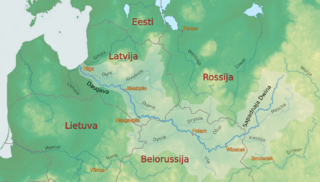
The Daugava or Western Dvina is a large river rising in the Valdai Hills of Russia that flows through Belarus and Latvia into the Gulf of Riga of the Baltic Sea. The Daugava rises close to the source of the Volga. It is 1,020 km (630 mi) in length, of which 352 km (219 mi) are in Latvia and 325 km (202 mi) in Russia. It is a westward-flowing river, tracing out a great south-bending curve as it passes through northern Belarus.
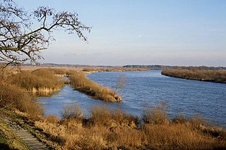
The Bug or Western Bug is a major river in Central Europe that flows through Belarus (border), Poland, and Ukraine, with a total length of 774 kilometres (481 mi). A tributary of the Narew, the Bug forms part of the border between Belarus and Poland for 178 kilometres (111 mi) and part of the border between Ukraine and Poland for 185 kilometres (115 mi).

The Velikaya is a river in Novosokolnichesky, Pustoshkinsky, Sebezhsky, Opochetsky, Pushkinogorsky, Ostrovsky, Palkinsky, and Pskovsky Districts of Pskov Oblast, as well as in the city of Pskov in Russia. It is the largest tributary of Lake Peipus and belongs to the drainage basin of the Narva. It is 430 kilometres (270 mi) long, and the area of its basin 25,200 square kilometres (9,700 sq mi). The name of the river literally means "Grand" or "Great" in Russian. The towns of Opochka, Ostrov and Pskov are located on the banks of the Velikaya. The principal tributaries of the Velikaya are the Alolya (right), the Issa (left), the Sorot (right), the Sinyaya (left), the Utroya (left), the Kukhva (left), the Cheryokha (right), and the Pskova (right).
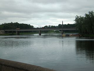
The Lovat is a river in Vitebsk Oblast of Belarus, Usvyatsky, Velikoluksky, and Loknyansky Districts, as well as of the city of Velikiye Luki, of Pskov Oblast and Kholmsky, Poddorsky, Starorussky, and Parfinsky Districts of Novgorod Oblast in Russia. The source of the Lovat is Lake Lovatets in northeastern Belarus, and the Lovat is a tributary of Lake Ilmen. Its main tributaries are the Loknya (left), the Kunya (right), the Polist (left), the Redya (left), and the Robya (right). The towns of Velikiye Luki and Kholm, as well as the urban-type settlement of Parfino, are located on the banks of the Lovat.

The Shosha is a river in Zubtsovsky, Staritsky, Kalininsky and Konakovsky districts of Tver Oblast and Lotoshinsky District of Moscow Oblast in Russia. It is a right tributary of the Volga. The length of the Shosha is 163 kilometres (101 mi). The area of its basin is 3,080 square kilometres (1,190 sq mi). The river flows into the Ivankovo Reservoir. The Shosha freezes up in November through early January and stays icebound until late March or early April.

The Mezha is a river in Nelidovsky, Zharkovsky, and Zapadnodvinsky Districts of Tver Oblast and Velizhsky District of Smolensk Oblast in Russia. It flows out of the Valdai Hills and continues west into the Daugava. The town of Nelidovo and the urban-type settlement of Zharkovsky are located along the Mezha. The Mezha is 259 kilometres (161 mi) long, and drains a basin of 9,080 square kilometres (3,510 sq mi). Its main tributaries are the Bereza, the Luchesa, the Obsha, and the Yelsha.

Demidov is a town and the administrative center of Demidovsky District in Smolensk Oblast, Russia, located on the Kasplya River at its confluence with the Gobza River. Population: 7,333 (2010 Census); 8,786 (2002 Census); 10,198 (1989 Soviet census). It was previously known as Porechye.

Rudnya is a town and the administrative center of Rudnyansky District in Smolensk Oblast, Russia, located on the Malaya Berezina River 68 kilometers (42 mi) northwest of Smolensk, the administrative center of the oblast. Population: 10,030 (2010 Census); 9,853 (2002 Census); 11,032 (1989 Soviet census).

Krasninsky District is an administrative and municipal district (raion), one of the twenty-five in Smolensk Oblast, Russia. It is located in the west of the oblast and borders with Rudnyansky District in the north, Smolensky District in the east, Monastyrshchinsky District in the south, Horki District of Mogilev Region of Belarus in the southwest, and with Dubrowna District of Vitebsk Region, also of Belarus, in the west. The area of the district is 1,507.67 square kilometers (582.11 sq mi). Its administrative center is the urban locality of Krasny. Population: 12,895 ; 15,537 (2002 Census); 18,758 (1989 Soviet census). The population of Krasny accounts for 33.7% of the district's total population.

The Sozh is a river flowing in Russia, Belarus, and Ukraine. It is a left bank tributary of the Dnieper. The Sozh passes through Gomel, the second largest city in Belarus.

Demidovsky District is an administrative and municipal district (raion), one of the twenty-five in Smolensk Oblast, Russia. It is located in the northwest of the oblast and borders with Zharkovsky District of Tver Oblast in the north, Velizhsky District in the northwest, Rudnyansky District in the southwest, Smolensky District in the south, and with Dukhovshchinsky District in the east. The area of the district is 2,514.02 square kilometers (970.67 sq mi). Its administrative center is the town of Demidov. Population: 14,039 ; 18,167 (2002 Census); 24,237 (1989 Soviet census). The population of Demidov accounts for 52.2% of the district's total population.

Dukhovshchinsky District is an administrative and municipal district (raion), one of the twenty-five in Smolensk Oblast, Russia. It is located in the north of the oblast and borders with Belsky District of Tver Oblast in the north, Kholm-Zhirkovsky District in the northeast, Yartsevsky District in the east, Kardymovsky District in the south, Smolensky District in the southwest, Demidovsky District in the west, and with Zharkovsky District of Tver Oblast in the northwest. The area of the district is 2,610.78 square kilometers (1,008.03 sq mi). Its administrative center is the town of Dukhovshchina. Population: 16,658 ; 19,182 (2002 Census); 23,720 (1989 Soviet census). The population of Dukhovshchina accounts for 42.4% of the district's total population.

Kardymovsky District is an administrative and municipal district (raion), one of the twenty-five in Smolensk Oblast, Russia. It is located in the center of the oblast and borders with Dukhovshchinsky District in the north, Yartsevsky District in the northeast, Dorogobuzhsky District in the east, Glinkovsky District in the southeast, Pochinkovsky District in the south, and with Smolensky District in the west. The area of the district is 1,093.15 square kilometers (422.07 sq mi). Its administrative center is the urban locality of Kardymovo. Population: 11,852 ; 12,521 (2002 Census); 13,505 (1989 Soviet census). The population of Kardymovo accounts for 39.3% of the district's total population.
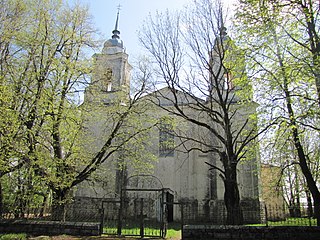
Rudnyansky District is an administrative and municipal district (raion), one of the twenty-five in Smolensk Oblast, Russia. It is located in the west and northwest of the oblast and borders with Velizhsky District in the north, Demidovsky District in the northeast, Smolensky District in the east, Krasnensky District in the south, and with Vitebsk, Liozna, and Dubrowna Districts of Vitebsk Region of Belarus in the west. The area of the district is 2,111.41 square kilometers (815.22 sq mi). Its administrative center is the town of Rudnya. Population: 25,244 ; 28,037 (2002 Census); 34,724 (1989 Soviet census). The population of Rudnya accounts for 39.7% of the district's total population.
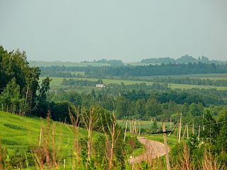
Smolensky District is an administrative and municipal district (raion), one of the twenty-five in Smolensk Oblast, Russia. It is located in the west of the oblast and borders with Demidovsky District in the north, Dukhovshchinsky District in the northeast, Kardymovsky District in the east, Pochinkovsky District in the south, Monastyrshchinsky District in the southwest, Krasninsky District in the west, and with Rudnyansky District in the northwest. The area of the district is 2,494.98 square kilometers (963.32 sq mi). Its administrative center is the city of Smolensk. Population: 44,964 ; 47,281 (2002 Census); 50,620 (1989 Soviet census).

The Usvyacha is a river in Kunyinsky and Usvyatsky Districts of Pskov Oblast in Russia and in Vitebsk Raion of Vitebsk Region in northern Belarus. A right tributary of the Daugava, the Usvyacha is 100 kilometres (62 mi) long, and its basin drains an area of 2,340 square kilometres (900 sq mi).

The Vikhra, or Vichra is a river in Smolensky, Krasninsky, and Monastyrshchinsky Districts of Smolensk Oblast, Russia, and Mstsislaw District of Mogilev Region, Belarus. A right tributary of the Sozh, the Vikhra flows through Monastyrshchinsky District and is 128 kilometres (80 mi) long. The urban-type settlement of Monastyrshchina is located on the banks of the Vikhra. The Battle of the Vikhra River occurred in the area.

The Ostyor, or Ascior is a river in Pochinkovsky, Roslavlsky, and Shumyachsky Districts of Smolensk Oblast in Russia and in Klimavichy and Krychaw Districts of Mogilev Region of Belarus. It is a left tributary of the Sozh. The Ostyor is 274 kilometres (170 mi) long, and has a 3,490 square kilometres (1,350 sq mi) basin. The town of Roslavl is located on the left bank of the Ostyor. The lower course of the Ostyor marks the state border between Russia and Belarus.

The Khmost is a river in Dukhovshchinsky, Smolensky, and Kardymovsky Districts of Smolensk Oblast, Russia, a right tributary of the Dnieper. The length of the river is 135 kilometres (84 mi), and the area of its drainage basin is 636 square kilometres (246 sq mi). The settlement of Kardymovo is located near the river mouth.
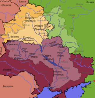
The Dnieper Basin is the drainage basin of the Dnieper River, covering an area of 531,817 square kilometres (205,336 sq mi). Its water resources compose around 80% of the total for all Ukraine.


