The Mologa is a river in Maksatikhinsky, Bezhetsky, Lesnoy, and Sandovsky Districts of Tver Oblast, Pestovsky District in Novgorod Oblast, and Ustyuzhensky and Cherepovetsky Districts in Vologda Oblast Russia. It is a left tributary of the Volga. The lower course of the Mologa has been turned into the Rybinsk Reservoir. It is 456 kilometres (283 mi) long, and the area of its basin 29,700 square kilometres (11,500 sq mi). The principal tributaries of the Mologa are the Osen (right), the Volchina (left), the Kobozha (left), the Chagodoshcha (left) and the Sit.

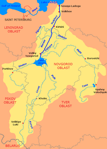
The Volkhov is a river in Novgorodsky and Chudovsky Districts of Novgorod Oblast and Kirishsky and Volkhovsky Districts of Leningrad Oblast in northwestern Russia. It connects Lake Ilmen and Lake Ladoga and forms part of the basin of the Neva. The length of the river is 224 kilometres (139 mi), and the area of its drainage basin is 80,200 square kilometres (31,000 sq mi). The city of Veliky Novgorod, the towns of Kirishi, Volkhov and Novaya Ladoga, and the historically important village of Staraya Ladoga are located along the Volkhov.
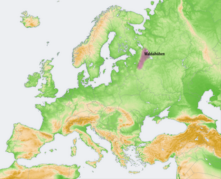
The Valdai Hills, sometimes shortened to Valdai, are an upland region in the north-west of central European Russia running north–south, about midway between Saint Petersburg and Moscow, spanning Leningrad, Novgorod, Tver, Pskov, and Smolensk Oblasts.

The Tvertsa is a river in Vyshnevolotsky, Spirovsky, Torzhoksky, and Kalininsky Districts, as well as in the cities of Torzhok and Tver in Tver Oblast, Russia, a left tributary of the Volga. It is 188 kilometres (117 mi) long, and the area of its basin 6,510 square kilometres (2,510 sq mi). The principal tributaries of the Tvertsa are the Malaya Tigma (left), the Shchegrinka (right), the Osuga (right), the Logovyazh (left), and the Kava (left).

Vyshny Volochyok is a town in Tver Oblast, Russia. Population: 52,370 (2010 Census); 56,405 (2002 Census); 64,789 (1989 Soviet census).
Borovichi is the second largest town in Novgorod Oblast, Russia, located on the Msta River in the northern spurs of the Valdai Hills, 194 kilometers (121 mi) east of Veliky Novgorod, the administrative center of the oblast. As of the 2010 Census, its population was 53,690.
The Berezayka is a river in Valdaysky District of Novgorod Oblast and Bologovsky District of Tver Oblast of Russia. It is left tributary of the Msta and belongs to the drainage basin of the Neva and the Baltic Sea. It is 150 kilometres (93 mi) long, and the area of its drainage basin is 3,230 square kilometres (1,250 sq mi). The principal tributary of the Berezayka is the Valdayka (left).
The Uver is a river in Moshenskoy and Borovichsky Districts of Novgorod Oblast. It is a right tributary of the Msta. It is 90 kilometres (56 mi) long, and the area of its basin 3,930 square kilometres (1,520 sq mi). The principal tributary is the Syezha (left).

The Tsna is a river in Kuvshinovsky, Ostashkovsky, Firovsky, and Vyshnevolotsky Districts of Tver Oblast of Russia. It flows into Lake Mstino, which is drained by the Msta and belongs to the drainage basin of the Neva and the Baltic Sea. It is 160 kilometres (99 mi) long, and the area of its basin 4,140 square kilometres (1,600 sq mi). The principal tributaries of the Tsna are the Belaya (right) and the Shlina, that flows into the Vyshny Volochyok Reservoir. In 1719, the river was dammed some 10 km above its mouth, creating the Vyshny Volochyok Reservoir.

Borovichsky District is an administrative and municipal district (raion), one of the twenty-one in Novgorod Oblast, Russia. It is located in the east of the oblast and borders with Khvoyninsky District in the north, Moshenskoy District in the east, Udomelsky District of Tver Oblast in the southeast, Bologovsky District of Tver Oblast in the south, Okulovsky District in the west, and with Lyubytinsky District in the northwest. The area of the district is 3,100 square kilometers (1,200 sq mi). Its administrative center is the town of Borovichi. Population: 15,675 (2010 Census); 19,085 ; 21,648 (1989 Soviet census).

Lyubytinsky District is an administrative and municipal district (raion), one of the twenty-one in Novgorod Oblast, Russia. It is located in the northeast of the oblast and borders with Tikhvinsky District of Leningrad Oblast in the north, Boksitogorsky District of Leningrad Oblast in the northeast, Khvoyninsky District in the east, Borovichsky District in the southeast, Okulovsky District in the southwest, Malovishersky District in the west, and with Kirishsky District of Leningrad Oblast in the northwest. The area of the district is 4,500 square kilometers (1,700 sq mi). Its administrative center is the urban locality of Lyubytino. Population: 9,744 (2010 Census); 12,432 ; 15,263 (1989 Soviet census). The population of Lyubytino accounts for 28.8% of the district's total population.

Okulovsky District is an administrative and municipal district (raion), one of the twenty-one in Novgorod Oblast, Russia. It is located in the center of the oblast and borders with Lyubytinsky District in the northeast, Borovichsky District in the east, Bologovsky District of Tver Oblast in the southeast, Valdaysky District in the southwest, Krestetsky District in the west, and with Malovishersky District in the northwest. The area of the district is 2,500 square kilometers (970 sq mi). Its administrative center is the town of Okulovka. Population: 25,808 (2010 Census); 31,153 ; 36,852 (1989 Soviet census). The population of Okulovka accounts for 48.3% of the district's total population.

Bologovsky District is an administrative and municipal district (raion), one of the thirty-six in Tver Oblast, Russia. It is located in the north of the oblast and borders with Borovichsky District of Novgorod Oblast in the north, Udomelsky District in the east, Vyshnevolotsky District in the southeast, Firovsky District and the urban-type settlement of Ozyorny in the south, Valdaysky District of Novgorod Oblast in the west, and with Okulovsky District, also of Novgorod Oblast, to the northwest. The area of the district is 2,463.7 square kilometers (951.2 sq mi). Its administrative center is the town of Bologoye. Population: 38,557 ; 18,757 (2002 Census); 32,790 (1989 Soviet census). The population of Bologoye accounts for 60.9% of the district's total population.

Firovsky District is an administrative and municipal district (raion), one of the thirty-six in Tver Oblast, Russia. It is located in the north of the oblast and borders with the urban-type settlement of Ozyorny in the north, Bologovsky District in the northeast, Vyshnevolotsky District in the east, Kuvshinovsky District in the south, Ostashkovsky District in the southwest, Demyansky District of Novgorod Oblast in the west, and with Valdaysky District, also of Novgorod Oblast, in the northwest. The area of the district is 1,836 square kilometers (709 sq mi). Its administrative center is the urban locality of Firovo. Population: 9,396 ; 11,919 (2002 Census); 14,282 (1989 Soviet census). The population of Firovo accounts for 25.9% of the district's total population.

Kuvshinovsky District is an administrative and municipal district (raion), one of the thirty-six in Tver Oblast, Russia. It is located in the center of the oblast and borders with Vyshnevolotsky District in the north, Torzhoksky District in the east, Staritsky District in the south, Selizharovsky District in the southwest, Ostashkovsky District in the west, and with Firovsky District in the northwest. The area of the district is 1,874 square kilometers (724 sq mi). Its administrative center is the town of Kuvshinovo. Population: 15,386 ; 17,847 (2002 Census); 20,601 (1989 Soviet census). The population of Kuvshinovo accounts for 65.0% of the district's total population.

Udomelsky District is an administrative and municipal district (raion), one of the thirty-six in Tver Oblast, Russia. It is located in the north of the oblast and borders with Moshenskoy District of Novgorod Oblast in the north, Lesnoy District in the northeast, Maksatikhinsky District in the east, Vyshnevolotsky District in the south, Bologovsky District in the west, and with Borovichsky District of Novgorod Oblast in the west. The area of the district is 2,476.2 square kilometers (956.1 sq mi). Its administrative center is the town of Udomlya. Population: 40,292 ; 10,401 (2002 Census); 12,426 (1989 Soviet census). The population of Udomlya accounts for 77.1% of the district's total population.
Vyshnevolotsky District is an administrative and municipal district (raion), one of the thirty-six in Tver Oblast, Russia. It is located in the north of the oblast and borders with Udomelsky District in the north, Maksatikhinsky District in the northeast, Spirovsky District in the east, Torzhoksky District in the south, Kuvshinovsky District in the southwest, Firovsky District in the west, and with Bologovsky District in the northwest. The area of the district is 3,400 square kilometers (1,300 sq mi). Its administrative center is the town of Vyshny Volochyok. Population: 25,421 ; 28,918 (2002 Census); 34,579 (1989 Soviet census).
The Kholova is a river in Krestetsky and Malovishersky Districts of Novgorod Oblast in Russia. It is a left tributary of the Msta. It is 126 kilometres (78 mi) long, and the area of its basin 1,900 square kilometres (730 sq mi). The principal tributaries of the Kholova are the Khuba (right) and the Moshnya (left). The urban-type settlement of Kresttsy is located on the Kholova.

The Shlina is a river in Firovsky, Bologovsky, and Vyshnevolotsky Districts, as well as of the closed urban-type settlement of Ozyorny of Tver Oblast of Russia. It is a tributary of the Tsna River and belongs to the drainage basin of the Neva and the Baltic Sea. It is 102 kilometres (63 mi) long, and the area of its basin 2,300 square kilometres (890 sq mi). The principal tributaries of the Shlina are the Granichnaya (right), the Shlinka (left), and the Lonnitsa (right). The Lonnitsa is technically an inflow of the Vyshny Volochyok Reservoir.

Vyshny Volochyok Waterway is a waterway connecting the basins of the Baltic and Caspian Seas, or, more specifically, the Msta River and the Tvertsa River, around the town of Vyshny Volochyok of Tver Oblast, Russia. It was constructed in the 1700s and became the first waterway to connect the basins of the two seas. The waterway is still in operation, though it was superseded by the Volga–Baltic Waterway and cannot take big ships. The Vyshny Volochyok Waterway is one of the three canal systems connecting the Neva and the Volga, the other two being the Volga–Baltic Waterway and the Tikhvinskaya water system.