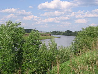
The Kostroma is a river in the European part of Russia. It flows through the Kostroma and Yaroslavl Oblasts, and becomes a left tributary of the Volga, which it enters at the Gorky Reservoir, at the city of Kostroma.

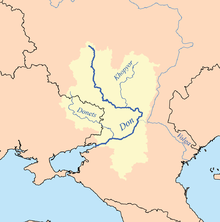
The Kuban is a river in Russia that flows through the Western Caucasus and drains into the Sea of Azov. The Kuban runs mostly through Krasnodar Krai for 660 kilometres (410 mi), but also in the Karachay–Cherkess Republic, Stavropol Krai and the Republic of Adygea.
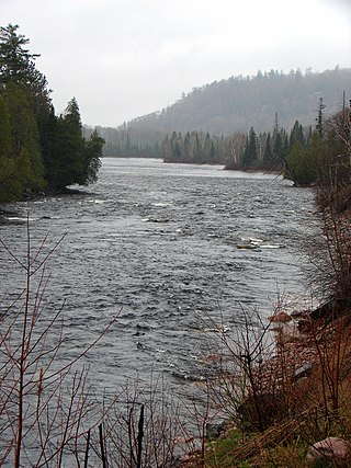
The Mississagi River is a river in Algoma and Sudbury Districts, Ontario, Canada, that originates in Sudbury District and flows 266 kilometres (165 mi) to Lake Huron at Blind River, Algoma District.

The Nizhnyaya Tunguska is a river in Siberia, Russia, that flows through the Irkutsk Oblast and the Krasnoyarsk Krai. The river is a right tributary of the Yenisey joining it at Turukhansk. The ice-free period on the Nizhnyaya Tunguska starts in mid-June and ends in the first half of October. The river forms the western limit of the Lena Plateau.

The Chusovaya is a river flowing in Perm Krai, Sverdlovsk Oblast and Chelyabinsk Oblast of Russia. A tributary of the Kama, which in turn is a tributary of the Volga, discharges into the Chusovskoy Cove of the Kamsky Reservoir. The river is remarkable in that it originates on the eastern slopes of the Ural Mountains in Asia, crosses the mountains, and mostly runs on their western slopes in Europe. The Chusovaya River is widely used as a source of water. In particular, its water is taken from the Volchikhinsky Reservoir, 37 square kilometres (14 sq mi), to the Verkhneisetsky Reservoir to supply the major city of Yekaterinburg. Fifteen smaller reservoirs are spread over about 150 tributaries of the river.

The Ardèche is a 125-kilometre (78 mi) long river in south-central France, a right-bank tributary of the River Rhône. Its source is in the Massif Central, near the village of Astet. It flows into the Rhône near Pont-Saint-Esprit, north-west of Orange. The river gives its name to the French department of Ardèche.

The Onega is a river in Kargopolsky, Plesetsky, and Onezhsky Districts of Arkhangelsk Oblast in Russia. The Onega connects Lake Lacha with the Onega Bay in the White Sea southwest of Arkhangelsk, flowing in the northern direction. The discharge at the source is 74.1 cubic metres per second (2,620 cu ft/s) and at the mouth is 505 cubic metres per second (17,800 cu ft/s). The river is 416 kilometres (258 mi) long, and the area of its basin 56,900 square kilometres (22,000 sq mi). Its main tributaries are the Voloshka (right), the Kena (left), the Mosha (right), the Kodina (right), and the Kozha (left). The major tributary of the Lake Lacha is the Svid.
The Syun is a river in Bashkortostan and Tatarstan, Russian Federation, a left-bank tributary of the Belaya. It is 209 kilometres (130 mi) long, of which 74 kilometres (46 mi) are in Tatarstan. Its drainage basin covers 4,500 square kilometres (1,700 sq mi). Major tributaries in Tatarstan are the Kalmiya, Sikiya, Terpelya, Bezyada, and Sharan in Bashkortostan. The maximal water discharge is 655 cubic metres per second (23,100 cu ft/s) (1979), and the maximal mineralization 500 to 1000 mg/L. Average sediment at the mouth per year is 120 millimetres (4.7 in). Drainage is regulated. Since 1978 it is protected as a "natural monument of Tatarstan".

The Kubnya is a river in Chuvashia and Tatarstan, Russian Federation, a left-bank tributary of the Sviyaga. It is 176 kilometres (109 mi) long, of which 121 kilometres (75 mi) are in Tatarstan, and its drainage basin covers 2,480 square kilometres (960 sq mi). It begins in Chuvashia and flows to the Sviyaga 4 kilometres (2.5 mi) south of Burunduki.

The Toyma is a river in Udmurtia and Tatarstan, Russian Federation, a right-bank tributary of the Kama. It is 121 kilometres (75 mi) long, of which 84 kilometres (52 mi) are in Tatarstan, and its drainage basin covers 1,450 square kilometres (560 sq mi). It begins in Udmurtia and falls to the Kama near Yelabuga, Tatarstan.
The Vorona is a river in the Penza, Tambov, and Voronezh oblasts in Russia. It is a right tributary of the Khopyor, and is 454 kilometres (282 mi) long, with a drainage basin of 13,200 square kilometres (5,100 sq mi). The average discharge at the mouth is 41.5 cubic metres per second (1,470 cu ft/s). The river is frozen over from the beginning of December to the first half of April. Its main tributary is the Chembar.

The Savala is a river in the Tambov and Voronezh oblasts of Russia. It is a right tributary of the Khopyor. The Savala is 285 kilometres (177 mi) long, with a drainage basin of 7,720 square kilometres (2,980 sq mi). It flows over the southern part of the Oka–Don Lowland. Its main tributary is the Yelan. Most of the river's waters are from melting snow. Its average discharge is 20 cubic metres per second (710 cu ft/s). It freezes over in late November, and stays icebound until the spring thaw starts in late March or early April. The town of Zherdevka is along the banks of the Savala.

The Konda is a river in the Khanty–Mansia region of Russia. The town of Uray and the Shaimskoye oil field are along the Konda.
The Usa is a river in the northeast corner of European Russia that drains the Polar Urals southwest into the Pechora. The Polar Urals tend to the northeast and the Usa runs parallel to them. It is in the Komi Republic of Russia and the largest tributary of the Pechora, which it joins from the right. It is 565 kilometres (351 mi) long, with a drainage basin of 93,600 square kilometres (36,100 sq mi).
The Inya is a river in Kemerovo and Novosibirsk Oblasts of Russia. It is a right tributary of the Ob. It is 663 kilometres (412 mi) long, with a drainage basin of 17,600 square kilometres (6,800 sq mi).
The Pyshma is a river in Sverdlovsk and Tyumen Oblasts of Russia. It is a right tributary of the Tura. It is 603 kilometres (375 mi) long, with a drainage basin of 19,700 square kilometres (7,600 sq mi).

The Bezdna is a river in Tatarstan, Russian Federation, a left-bank tributary of the Volga, flowing into the Kuybyshev Reservoir near Kuralovo, Spassky District. It is 45 kilometres (28 mi) long, and its drainage basin covers 805 square kilometres (311 sq mi).
The Redstone River is a large river in the Northwest Territories of Canada. It is about 289 kilometres (180 mi) long. It is a tributary of the Mackenzie River, joining it on the left bank some 100 kilometres (62 mi) north of Wrigley. Draining a rugged and high area of the Mackenzie Mountains, the Redstone watershed is sparsely populated by people but remains an ecological haven for wildlife including moose, caribou, wolves Dall's Sheep and Bears. It is a pristine mountain wilderness.

The Cleurie or rupt de Cleurie is a river in Lorraine in France, which flows in the Vosges department. It is a right tributary of the Moselotte, and thus a sub-tributary of the Rhine, via the Moselotte and the Moselle. It is 18.9 km (11.7 mi) long.

The Fensch or Fentsch is a river in the Moselle department of the Grand Est region of France. It is a left tributary of the Moselle, and thus a sub-tributary of the Rhine.