Kaviyoor

Last updated

Kaviyoor
Kaviyur
Village
KaviyoorTemple-EastGate-Dinakarr-May2011-DSC0032.jpg
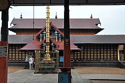
Kaviyoor Temple, Main Entrance
India Kerala location map.svg
Red pog.svg
Kaviyoor
Kaviyoor (Kerala)
India location map.svg
Red pog.svg
Kaviyoor
Kaviyoor (India)
Coordinates: 9°24′00.7″N76°36′49.7″E / 9.400194°N 76.613806°E / 9.400194; 76.613806
Country Flag of India.svg  India
State Kerala
District Pathanamthitta
Elevation
55.33 m (181.53 ft)
Languages
  Official Malayalam, English
Time zone UTC+5:30 (IST)
PIN
689582 [1]
Vehicle registration KL-27 THIRUVALLA
Coastline0 kilometres (0 mi)
Climate Tropical monsoon (Köppen)
Avg. summer temperature35 °C (95 °F)
Avg. winter temperature20 °C (68 °F)

Kaviyoor is a village located in Thiruvalla taluk in Pathanamthitta [2] of Kerala in India, situated on the western bank of the Manimala River. [3] It comes under Thiruvalla sub-district & Thiruvalla constituency.

Contents

Demographics

(Note: These figures are based on statistics of Census Dept. The summary given by them is different: Literacy 98.27%, M - 98.64%, F - 97.96%)

Majority of the residents belong to the Hindu community. The total population is estimated to be about 16,852 people with a literacy rate of about 97%.

See also

Related Research Articles

<span class="mw-page-title-main">Changanassery</span> Town in Kerala, India

Changanassery, also spelt Changanacherry, is a municipality in Kottayam district in Kerala, India. It is also the headquarters of the Changanassery Taluk. The town is spread over an area of 14.3 km2 (5.5 sq mi) and has a population of 47,685. Changanassery is located 17 km (11 mi) south of the district headquarters Kottayam and 117 km (73 mi) north of the state capital Thiruvananthapuram.

<span class="mw-page-title-main">Pathanamthitta district</span> District in Kerala, India

Pathanamthitta District, is one of the 14 districts in the Indian state of Kerala. The district headquarters is in the town of Pathanamthitta. There are four municipalities in Pathanamthitta: Adoor, Pandalam, Pathanamthitta and Thiruvalla.

<span class="mw-page-title-main">Thiruvalla</span> City in Kerala, India

Thiruvalla, also spelled Tiruvalla, is a municipality in Pathanamthitta district, Kerala, India. It is also the headquarters of the Thiruvalla taluk. The town is spread over an area of 25.5 km2 (9.8 sq mi) and has a population of 52,883, down from 56,837 in 2001. It lies on the northern banks of the Manimala River, in a land-locked region surrounded by irrigating canals and rivers. It is the largest town in the district, and is one of the financial, educational, cultural, and commercial centres of central Travancore.

<span class="mw-page-title-main">Mavelikkara</span> Town in Kerala, India

Mavelikara is a taluk and municipality in the Onattukara region of Alappuzha district in the Indian state of Kerala. Located in the southern part of the district on the banks of the Achankovil River.

<span class="mw-page-title-main">Azhikode and Azhikkal</span> Town in Kerala, India

Azhikode is a coastal town and a suburb of Kannur city situated in Kannur district of Kerala, India. Azhikode town is divided into Azhikode North and Azhikode South. The northern end of the Azhikode North is called Azhikkal. The place is the birthplace of Sukumar Azhikode, an influential thinker and literary critic. It is about 7 km (4.3 mi) from Kannur city.

<span class="mw-page-title-main">Ranni, Kerala</span> Taluk in Kerala, India

Ranni or Ranny is a town in the Pathanamthitta district of Kerala, India, and the 16th largest taluk in Kerala, located on both sides of the Pamba River. It Is located 27 km from Chengannur railway station & NH 183 in Chengannur.

<span class="mw-page-title-main">Pathanamthitta</span> Town in Kerala, India

Pathanamthitta, is a municipality situated in the Southern Kerala, India, spread over an area of 23.50 km2. It is the administrative capital of Pathanamthitta district. The town has a population of 37,538. The Hindu pilgrim centre Sabarimala is situated in the Pathanamthitta district; as the main transport hub to Sabarimala, the town is known as the 'Pilgrim Capital of Kerala'. Pathanamthitta District, the thirteenth revenue district of the State of Kerala, was formed with effect from 1 November 1982, with headquarters at Pathanamthitta. Forest covers more than half of the total area of the District. Pathanamthitta District ranks the 7th in area in the State. The district has its borders with Allepey, Kottayam, Kollam and Idukki districts of Kerala and Tamil Nadu. Nearest city Is Thiruvalla, located at a distance of 30 km. Thiruvalla railway station Is 30 km via Thiruvalla-Kumbazha highway. Buses ply every 5 Minutes from Thiruvalla To Pathanamthitta & vice versa.

<span class="mw-page-title-main">Puthuppally, Kottayam</span> Town in Kerala, India

Puthuppally is one of the few major centers and towns in the Kottayam district of Kerala, India as many areas can be reached only via Puthuppally. The community is known for its ancient Malankara Orthodox Syrian Church, Puthuppally Palli. The town is growing further owing to the increasing number of major roads connecting it to other major towns in the region.

Pullad is a town in Thiruvalla in the Pathanamthitta district, Kerala. Pullad is a part of Koipuram village. It is designated as a "Special Grade below Municipality level". Situated 12 km east from Thiruvalla SCS Junction and 3 km from Kumbanad along the TK Road.It Is Part Of Thiruvalla Sub-District.

<span class="mw-page-title-main">Venmony</span> Village in Kerala, India

Venmony is a village in Chengannur taluk of Alappuzha district of Central Travancore area in Kerala state, India. Venmoney is 18 km south of Thiruvalla, 11 km east of Mavelikkara and 9 km northwest of Pandalam. 12 km from Chengannur. It is located 55 km towards East from District headquarters Alappuzha. 107 km from State capital Thiruvananthapuram and 138 km from Cochin International Airport. The village is on the border of the Alappuzha District and Pathanamthitta District. The Achenkovil river flows on its southern boundary and is spanned by the Pulakadavu bridge.

Kadannapalli is a census town in Kannur district of Kerala state, India.

<span class="mw-page-title-main">Thirumeni</span> Village in Kerala, India

Thirumeni is a village in Kannur district in the Kerala state of India. It is known for its hill station Chathamangalam Hills. The village has several recently migrated families from various parts of the erstwhile political entity (state) of Travancore who settled here in the famed "Malabar migration period" in the nineteenth century. Most of the inhabitants of the village reside in the valley of three major hills by name Chathamangalam Theruvamala alias Alumbumala, Kottathalachimala and Thevarkunnumala. Thirumeni is a small junction with a few government institutions, religious institutions and small shops in int. and is subdivided into smaller villages like Kokkadave, Prapoyil, Chathamangalam (Kannur), Thabore, Muthuvom, Korali, Chattivayal, Thannichal, Paruthikallu etc.

Eraviperoor is a village in Thiruvalla Taluk,Pathanamthitta district in the state of Kerala. Eraviperoor is the part of Thiruvalla Taluk in east location and is part of the Aranmula legislative assembly constituency.It Comes Under Thiruvalla Sub-District.Located At 8 km Distance From Thiruvalla Sub-District Headquarter And NH 183 In Thiruvalla City India.

<span class="mw-page-title-main">Ezhumattoor</span> Village in Kerala, India

Ezhumattoor is a village in Pathanamthitta district in the state of Kerala, India.It Is Part Of Thiruvalla Constituency.It has 27.89 km2 area,it is divided into 14 wards for administrative purpose,it was formed by a government Order on 16 January 1952.

Kadapra is one of the developing Area in Thiruvalla Taluk, Pathanamthitta district in the state of Kerala, India. It lies near to Parumala and Niranam. Much development is occurring.It Is Part Of Thiruvalla Sub-District.It Also Comes Under Thiruvalla Constituency.

Kavumbhagom, also spelled Kavumbhagam, is a ward and a census village in Thiruvalla municipality, in the Pathanamthitta district of Kerala, India. The village has a population of 6644 as of 2011. Kavumbhagom is an important junction serving as a major road route connecting Changanasserry, Thiruvalla, Chathenkary, and Mavelikkara. The Thiruvalla Sree Vallabha temple, after which the town of Thiruvalla has been named, is located in Kavumbhagom.

Koipuram is a large census village in Tiruvalla, Pathanamthitta district in the state of Kerala, India. Kumbanad, Muttumon, Pullad, Poovathoor, are the nodal points.

Peringara is a village and in the Peringara gram panchayat in Pathanamthitta district, Kerala. Peringara is located 3.9 km from Thiruvalla. The gram panchayat includes the wards of Mepral, Idinjillam, Perumthuruthy, and Chathenkary.

Thelliyoor is a village Near Thiruvalla in Pathanamthitta district in the state of Kerala, India.

The Pathanamthitta district has four types of administrative hierarchies:

References

  1. "KAVIYOOR Pin Code - 689582, Tiruvalla All Post Office Areas PIN Codes, Search PATHANAMTHITTA Post Office Address". news.abplive.com. Retrieved 19 November 2023.
  2. "Revenue Portal". village.kerala.gov.in. Retrieved 19 November 2023.
  3. "Kaviyoor, India Tourist Information". www.touristlink.com. Retrieved 19 November 2023.