Kadampanad

Last updated

Kadampanad
village
St.Thomas Malankara Syrian Orthodox Cathedral, Kadampanad, Adoor, Established - AD 325.jpg
Kadampanad Cathedral
Coordinates: 9°7′0″N76°41′0″E / 9.11667°N 76.68333°E / 9.11667; 76.68333
CountryFlag of India.svg  India
State Kerala
District Pathanamthitta
Population
 (2001)
  Total26,880
Languages
  Official Malayalam, Hindi, English
Time zone UTC+5:30 (IST)
PIN
691553
Telephone code04734
Vehicle registration KL-26
Nearest city ADOOR
Lok Sabha constituencyPathanamthitta
Vidhan Sabha constituencyAdoor
Website https://kadampanad.com/

Kadampanad grama panchayath is the southernmost part of Pathanamthitta district. It comes under Parakkode block of Adoor taluk. The panchayath shared boundaries with Erathu panchayath in the north, Ezhamkulam panchayath in the east, Kunnathur panchayath and Kalladayar in the south and Pallikkal and Poruvazhy Panchayaths in the west. Kakkathikkunnu in the north and Pandimalakkunnu (Pandimalappuram) in the south stands as two strong forts in this panchayath which balances the climatic conditions of this area.

Contents

Kadampanad, Kallukuzhi, Thuvayoor and Mannadi areas form Kadampanad panchayath. Mannadi is known as the place where Veluthambi Dalawa, the great freedom fighter, died.

Etymology

The name Kadampanad might have been derived from the word " khada nadu". [1] There is also a belief that this place was occupied by Kadampa dynasty kings and hence the name Kadampanad was derived.

History

It is mentioned in many literary works of Sangha period like "Pathittupathu" that Kadampanad was a part of ancient Tamil Nadu. The beautiful architecture of Parakkadavu snanaghatas and kalmandapas, built on the banks of Kallada river, in connection with the Pazhayakavu and Puthiyakavu devi temple of Mannadi are proofs of ancient civilization in this place. Kadampanad was a trade center [2] in the ancient period. Under the Kulashekhara kings, who ruled Travancore with Mahodayapuram as their headquarters, there were many autonomous provinces. Kadampanad was such a province under the control of a Naduvazhi. [3] After the decline of Kulasekhara reign, Kadampanad came under the rule of Venad Kings. [4] Later, Kadamapanad became the part of Kayamkulam territory and when Marthanda Varma formed modern Travancore, it fell under this region. When Sir C.P. Ramaswamy Iyyer was the Divan of Central Travancore, Village uplift unions were formed for the development of villages in Kerala. The village uplift unions were composed of Government nominated representatives. The places come under Kadampanad grama panchayath were part of Kunnathur uplift union at that time. Thonnuram Panthiyil K. Kesavakurup was the president of Kunnathur uplift union. In 1953, when panchayaths formed, panchayath bodies elected by people came into being. The first president of the elected body of Kadampanad panchayath was Koyippurath K. Neelakandan Nair. After the formation of Kerala State, Kadampanad panchayath continued to be a part of Kollam district, under Kunnathur Taluk. In 1983, when Pathanamthitta district was formed, Kadampanad panchayath became a part of it.

Geography

Kadampanad panchayath covers an area of 23.95 km2. The land is situated in a slanting position from east to west and from south to north. Kallada and Pallickal rivers flow along the south and west sides of the panchayat respectively. The land consists of hilly areas, plains and paddy fields. Paddy, coconut and tapioca were cultivated abundantly in this region. Mannadi and Thuvayoor are two important places in this panchayath. Major portion of Thuvayoor was laid down as a corridor in the east–west direction between the Kakkathikkunnu and Pandimalakkunnu.

Divisions

There are 17 wards in Kadampanad grama panchayath. [5]

Demographics

As per the latest India census, Kadampanad has a population of 26839 with 12769 males and 14070 females. [6] The literacy rate as per the census data is 92.2%

Culture

Religious

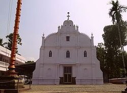
St. Thomas Orthodox Cathedral (Kadampanad Church),St. John’s Orthodox Syrian Church Thuvayoor, St. George Malankara Catholic Church, Shalom Marthoma Church, St. Andrew's Marthoma Church, '''St. Mary's orthodox church kadampanad north''', St. Thomas Catholic Church, St. Mary’s Catholic Church, St. Thomas Marthoma Church, St. Peter's Marthoma Church, Lourdes Matha Church and St. James CSI Church are the Christian devotional centres in this panchayath.The Church of God at Thuvayoor is the first Pentecostal church in Kerala. The Jama-ath mosques in Mannadi and Nilakkal are also part of the diverse culture of this place.

The Kadampanad Bhagavathy Temple and the Kundom Vettuthu Malanada temple,kochuveettil Bhagavathy temple,the Maharshi Mangalam temple in Thuvayoor, the Kannankara Yakshi temple in Manjali junction, the Mudippura Devi temple, Pazhayakavu and Puthiyakavu Devi temples in Mannadi are the important temples in Kadampanad Panchayath. Kadampanad panchayath consists of 8 other temples also.

Tourist Spots

The memorial of Veluthambi Dalawa and the Aravakkalu Chani Cave in Mannadi are places of tourist attractions. The Kerala institute of folklore and folk arts also functions in Mannadi.

See also

Related Research Articles

<span class="mw-page-title-main">Pathanamthitta district</span> District in Kerala, India

Pathanamthitta District, is one of the 14 districts in the Indian state of Kerala. The district headquarters is in the town of Pathanamthitta. There are four municipalities in Pathanamthitta: Adoor, Pandalam, Pathanamthitta and Thiruvalla.

<span class="mw-page-title-main">Nedumangad</span> Municipality in Kerala, India

Nedumangad is a municipal town in the Thiruvananthapuram district in the Indian state of Kerala. It is the headquarters of Nedumangad Tehsil and Nedumangad Revenue Division. It is a suburb of the extended metropolitan region of Thiruvananthapuram. It is located around 16 km (9.9 mi) to the north-east of Thiruvananthapuram on the State Highway 2. It is an important commercial center in the district. It is a growing commercial and educational hub and all important government institutions are situated in the town. The Nedumangadu market has significance in southern Kerala.

<span class="mw-page-title-main">Kollam district</span> District in Kerala, India

Kollam district, is one of 14 districts of the state of Kerala, India. The district has a cross-section of Kerala's natural attributes; it is endowed with a long coastline, a major Laccadive Sea seaport and an inland lake. The district has many water bodies. Kallada River is one among them, and land on the east bank of the river is East Kallada and that on the west bank is West Kallada.

<span class="mw-page-title-main">Adoor</span> Municipality in Kerala, India

Adoor is a municipality in the Pathanamthitta district of Kerala, India. It is the headquarters of the Adoor Taluk and Adoor Revenue Division. Adoor is located 18 km (11.2 mi) southwest of the district headquarters Pathanamthitta and 85 km (52.8 mi) north of the state capital Thiruvananthapuram.

<span class="mw-page-title-main">Chengannur</span> Municipal Town in Kerala, India

Chengannur is a municipality and Town in Alappuzha district, Kerala, India. It is also the headquarters of the Chengannur Taluk. Chengannur is located in the south-eastern part of the district, in the region known as Odanad, along the banks of Pamba River. Chengannur is 36 kilometres (22 mi) southeast of the district headquarters Alappuzha and 117 kilometres (73 mi) north of the state capital Thiruvananthapuram. Both the NH 183 and Main Central Road pass through the town.

Edathala is a gram panchayat near Aluva town. It is also a village in Aluva taluk of Ernakulam district, in the state of Kerala, India.

<span class="mw-page-title-main">Thalavoor</span> Village in Kerala, India

Thalavoor is a village located in the district of Kollam in the Kerala state of India. It is 77 km to the north of the State Capital, Thiruvananthapuram, and 28 km to the east of District Capital, Kollam. Thalavoor village is bordered by Pattazhy village to the north, Pidavoor village to the north-east, Vilakkudy village to the south-east, Melila village to the south and Mylom village to the west. Thalavoor is a part of Pathanapuram Block Panchayat

Padanilam is a town located in Onattukara region of Alappuzha district, Kerala. The word Padanilam means "land of battles". It is located on the banks of river Achankovil. The Padanilam temple is one of the important centres of worship in Kerala. Nooranad is named as the Nandikesha Paithruka Gramam by the Government of Kerala due to its importance in kettukala construction, which is an icon of Onattukara region.

<span class="mw-page-title-main">Sooranad</span> Village in Kerala, India

Sooranad North is a village in Kollam district in the south west Indian state of Kerala. It is believed that Sooranad was ruled by King SOORAN and hence the name.

Kulanada is a village in the district of Pathanamthitta bordering with Alappuzha district in Kerala state within India. Kulanada assumed its name from the combination of words "Kulam" and "Nada". Kulam meaning pond and Nada meaning the temple where the king of Pandalam worshiped.

<span class="mw-page-title-main">Kallada River</span> River in South kerala

The Kallada River is the longest river in Kollam District, Kerala, India. The river originates in Kulathupuzha, in the Western Ghats, and flows west, reaching the Arabian Sea after traveling a distance of 120 km (75 mi).

Karunagappally is a municipality in the Kollam district of Kerala, India. It is 24 km north of Kollam and 60 km (37 mi) south of Alappuzha. Karunagappally taluk consists of Alappad, Ochira, Adinad, Karunagappally, Thazhava, Pavumba, Thodiyoor, Kallalibhagom, Thevalakkara, Chavara, Neendakara, Clappana, Kulasekharapuram, Thekkumbhagam, Ayanivelikulangara, Panmana, Ponmana and Vadakumthala. The taluk is bound on the north by Kayamkulam, on the east by Kunnathur taluk, on the south by Kollam and on the west by the Arabian Sea. It is one of the fastest developing towns in Kerala and is part of Kollam metropolitan area.

Thadiyoor is a town located in Mallappally and Ranni taluks of Pathanamthitta district. It is part of both Ezhumattoor and Ayroor Panchayaths. It is Approximately 18kms from Thiruvalla and 11kms from Ranni.

Kunnathur (Kunnattūr,കുന്നത്തൂർ) is a taluk in Kollam district in the Indian state of Kerala.

<span class="mw-page-title-main">Nooranad</span> Town in Kerala, India

Nooranad is a developing town in Mavelikkara taluk of Alappuzha district in the Indian state of Kerala. It is located at a distance of 8 Km south-west of Pandalam, in Kayamkulam route. Padanilam is the cultural centre of Nooranad region. The Padanilam Parabrahma Temple, known for the biggest Shivarathri Kettukazhcha in Kerala, is situated in Nooranad. Nooranad is declared by the Government of Kerala as the Nandikesha Paithruka Gramam due to its importance in Kettukala making, which is an icon of Onattukara region of Central Travancore. Nooranad is also known as Pakshi Gramam of kerala.

Kallooppara is a village near Thiruvalla in Pathanamthitta district in the state of Kerala, India. It is part of the Thiruvalla constituency.

Mylapra is a village in Pathanamthitta district in the Indian state of Kerala. It comes under the Mylapra Panchayath. It is on the way to the famous Hindu pilgrim center of Sabarimala. The Main Eastern Highway passes through Mylapra.

Mannadi is a village in Kadampanad grama panchayat at Adoor Taluk, Pathanamthitta District of Kerala, India.

<span class="mw-page-title-main">St. Thomas Orthodox Cathedral, Kadampanad</span> Church in Kerala, India

St. Thomas Orthodox Cathedral, Kadampanad, popularly known as Kadampanad Church is an ancient church of Saint Thomas Christians situated in the Central Travancore village of Kadampanad, in Pathanamthitta District, Kerala, India. This Church belongs to the Malankara Orthodox Syrian Church under the Diocese of Adoor-Kadampanad.

References

  1. Prof. A.P. Shankunni Nair; Dr. N.V. Krishnawarier (24–30 November 1991). Mathrubhumi Weekly, Book 69. 38.{{cite journal}}: Missing or empty |title= (help)
  2. L.K. Ananthakrishna Ayyar (1930). "Anthropology of the Syrian Christians". Nature. 125 (3162): 15. Bibcode:1930Natur.125S.852.. doi: 10.1038/125852c0 .
  3. "Pattazhi chembupattayam". 971.{{cite journal}}: Cite journal requires |journal= (help)
  4. Shri Veera Deva Marthandavarma (343). "description about the geography of Chengazhinnur". Kilimanoor Shasana.
  5. panchayath/general-information/ "Kadampanad, General Information" . Retrieved 13 April 2013.{{cite web}}: Check |url= value (help)
  6. "India Census". Archived from the original on 11 February 2008. Retrieved 13 April 2013.