
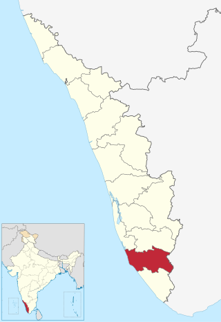
Pathanamthitta District, is one of the 14 districts in the Indian state of Kerala. The district headquarters is in the town of Pathanamthitta. There are four municipalities in Pathanamthitta: Adoor, Pandalam, Pathanamthitta and Thiruvalla.
Kollam district, is one of 14 districts of the state of Kerala, India. The district has a cross-section of Kerala's natural attributes; it is endowed with a long coastline, a major Laccadive Sea seaport and an inland lake. The district has many water bodies. Kallada River is one among them, and land on the east bank of the river is East Kallada and that on the west bank is West Kallada.
Kayamkulam is a municipality in the Alappuzha district of Kerala, India. It is located 90 km (55.9 mi) south of the district headquarters in Alappuzha and about 98 km (60.9 mi) north of the state capital Thiruvananthapuram. As per the 2011 Indian census, Kayamkulam has a population of 68,634 people, and a population density of 3,149/km2 (8,160/sq mi).
Adoor is a municipality in the Pathanamthitta district of Kerala, India. It is the headquarters of the Adoor Taluk and Adoor Revenue Division. Adoor is located 18 km (11.2 mi) southwest of the district headquarters Pathanamthitta and 85 km (52.8 mi) north of the state capital Thiruvananthapuram.
The Main Central Road popularly known as MC Road is the arterial State Highway starting from Kesavadasapuram in Trivandrum city and ends at Angamaly, a suburb of Kochi city in Ernakulam District, in the state of Kerala, India. It is designated as State Highway 1 by the Kerala Public Works Department. The highway was built by Raja Kesavadas, Dewan of Travancore, in the 1790s. Plan for a new highway called Thiruvananthapuram–Angamaly Greenfield Highway, which runs parallel to the MC Road is proposed and is under early stage of development.

Kottarakkara, also transliterated as Kottarakara, is a town and municipality in the Kollam district of the Kerala, India. Kottarakkara lies 27 kilometres (17 mi) to the east of Kollam city centre.

Pathanamthitta, is a municipality situated in the Southern Kerala, India, spread over an area of 23.50 km2. It is the administrative capital of Pathanamthitta district. The town has a population of 37,538. The Hindu pilgrim centre Sabarimala is situated in the Pathanamthitta district; as the main transport hub to Sabarimala, the town is known as the 'Pilgrim Capital of Kerala'. Pathanamthitta District, the thirteenth revenue district of the State of Kerala, was formed with effect from 1 November 1982, with headquarters at Pathanamthitta. Forest covers more than half of the total area of the District. Pathanamthitta District ranks the 7th in area in the State. The district has its borders with Allepey, Kottayam, Kollam and Idukki districts of Kerala and Tamil Nadu. Nearest town is Thiruvalla, located at a distance of 30 km. Thiruvalla railway station is 30 km via Thiruvalla-Kumbazha highway. Buses ply every 5 Minutes from Thiruvalla To Pathanamthitta & vice versa.

Konni, also spelt Konny, is a town and taluk headquarters in Pathanamthitta district of Kerala, India. Konni is known for its elephant cages, forests, and rubber plantations. It is also known as "Aanakoodinte Nadu". Nearest town is Pathanamthitta. Konni is located 32 km (20 mi) from Chengannur railway station and NH 183 in Chengannur. It is well-connected via Muvattupuzha - Punalur state highway. Buses ply frequently from Pathanamthitta KSRTC bus station to Konni.

The Main Eastern Highway is the lifeline of the high range townships of the Travancore region of Kerala state, India. It is also known as Punalur-Muvattupuzha Highway. Main Eastern Highway is categorized as State Highway - 08 of Kerala. It is the second longest State Highway of Kerala covering a distance of 153.6 km. The districts it passes through are Kollam, Pathanamthitta, Kottayam, Idukki and Ernakulam.
Elikkattoor is a village in India near Punalur, Kerala.
Kunnicode is a town on NH 744 in the Kollam District.
Enadimangalam is a village in the Pathanamthitta district of the state of Kerala, India. Enadimagalam includes mainly Elamanoor and Maroor. Enadimagalam is often recognised as a Panchayat. Enadimangalam had a population of around 30,000.
Ezhamkulam is a village in Adoor Thaluk of Pathanamthitta district in the state of Kerala, India. It is located about 5 km from central Adoor.

Kalanjoor is a village located in Pathanamthitta district state of Kerala, India. The place is 22 km away from district headquarters. As a part of Konni Assembly constituency and Pathanamthitta Lok Sabha constituency. Kalanjoor is also a panchayath where share the border of Kollam and Pathanamthitta district as the part of Parakode Block Panchayat.
Pathady / pathadi is a village about 6 km east from Anchal town, east of Kollam district, Kerala state, India.
Yeroor is a village situated near Anchal, Kollam district, Kerala, India.
Nadutheri is a village near Thalavoor in Kollam District, Kerala state, India.

Konni State assembly constituency is one of the 140 state legislative assembly constituencies in Kerala state in southern India. It is also one of the 7 state legislative assembly constituencies included in the Pathanamthitta Lok Sabha constituency. As of the 2021 Kerala Legislative Assembly election, the current MLA is K. U. Jenish Kumar of CPI(M).
Arukalickal is a small Village/hamlet in Parakode block in Pathanamthitta District of Kerala State, India. It comes under Ezhamkulam Panchayath. It belongs to South Kerala Division. It is located 15 km south of the district headquarters Pathanamthitta, 1 km from Parakode, and 89 km from the state capital Thiruvananthapuram.

Adoor State assembly constituency is one of the 140 state legislative assembly constituencies representing Adoor in the Pathanamthitta district of the state Kerala in India. It is also one of the 7 state legislative assembly constituencies included in the Pathanamthitta Lok Sabha constituency. The current MLA is Chittayam Gopakumar of CPI.


