Aarhus C is a postal district in the city of Aarhus, Denmark, consisting of the Inner city, Vesterbro, University of Aarhus, Frederiksbjerg, Langenæs and Aarhus Ø, with postal code 8000. The district is commonly defined as the area enclosed by the ring road of Ring 1, and in the west by the Aarhus Harbour and shoreline.

The Church of Our Lady is one of the larger church structures of Århus, Denmark. It is situated in the centre of the city not far from Aarhus Cathedral. The church and associated structures were built in several stages in the course of the Middle Ages, from the late 1200s to 1500 AD. The original church at the site, stood finished as early as 1060 AD, but only the stone crypt remains today as evidence of its existence.

Midtbyen, also known as Aarhus Center or City, is the inner part of Aarhus. Midtbyen is part of district Aarhus C, mainly with postal code 8000, together with Vesterbro, Nørre Stenbro Trøjborg and Frederiksbjerg and has a population of around 90000
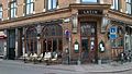
Latinerkvarteret in Aarhus, is the oldest part of the city and is itself part of the inner city. The quarter comprise the streets of Badstuegade, Klostergade, Volden, Studsgade, Borggade, Rosensgade, Mejlgade and Graven, with Pustervig Torv as the main square.

Our Lady's Priory, Aarhus was an early Dominican foundation just outside the original walls of Aarhus, Denmark. The buildings are part of the Church of Our Lady complex, now part of the inner city of Aarhus, but they have been repurposed.

The Aarhus School of Architecture was founded in 1965 in Aarhus, Denmark. Along with the Royal Danish Academy of Fine Arts, School of Architecture in Copenhagen, it is responsible for the education of architects in Denmark. The school has approximately 750 students.
Indre By is a neighborhood in the city of Aarhus, Denmark. The neighborhood is bounded by Nørre Allé, Vester Allé and Sønder Allé and is composed of the neighborhood and historical centre of the Latin Quarter and the areas around the Central Station and the City Hall Park. The neighborhood is one of the three main neighborhoods in the district of Aarhus C, along with Frederiksbjerg and Vesterbro.

St. Oluf Cemetery is a small public park and historic site in central Aarhus, Denmark. The park is situated by the coast in the city center of Midtbyen, in the Latin Quarter, bounded by the streets of Kystvejen and St. Olufs Stræde, overlooking the Docklands and the Bay of Aarhus in the East. It is one of only two green spaces in the historic inner city, the other one being Frue Kirkeplads at the Church of Our Lady, but is one of five protected scheduled monuments.

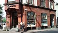
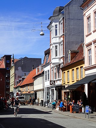
Mejlgade is a street in Aarhus which runs north to south from Østbanetorvet to Skolegade and intersects Nørrebrogade. The street is situated in the historic Latin Quarter neighborhood and has the highest number of historic and listed buildings in the city. Mejlgade is one-way and no-parking zone for cars for most of its length and pedestrians and cyclists are given priority. The single lane is tiled and a part of the Cykelringen bicycle ring which circumnavigates the city center. Mejlgade has a high number of small specialty shops and some cafés and bars.
Vestergade is a street in Aarhus, Denmark, which runs east to west from the central square of Store Torv to the city park of Åparken at Carl Blochs Gade, intersecting the main streets of Grønnegade and Vester Allé along its course. Vestergade begins in the Indre By neighborhood and ends in neighborhood of Vesterbro, close to CeresByen. Vestergade has some of the best preserved 18th-century merchant estates in Aarhus and a history of creativity and artistic expression.
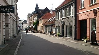
Studsgade is a street in Aarhus which runs north to south from Nørreport to Klostergade and Graven. The street is situated in the historic Latin Quarter neighborhood and is home to four listed buildings. The street has existed since at least the 1400s, when it was known as Sturisgade and Stus Gaden, probably for councillor Jep Sture, who had a house there. It was officially given its current name in 1796.

Rudolf Frimodt Clausen was a Danish architect born in Copenhagen on 29 June 1861 to the bishop Johannes Clausen and grandson of the theologian Henrik Nicolai Clausen.

Catholic Church of Our Lady is a church in Aarhus, Denmark. The church is situated in the central Indre By neighbourhood on the pedestrian street Ryesgade, close to the Central Station and City Hall. It is a catholic church under the Roman Catholic Diocese of Copenhagen; built between 1877 and 1880 by designs of the German architect Franz Schmitz and later renovated by the architect Carl R. Frederiksen. The church has seating for 500 people.

The Concert Hall Park is a public park in central Aarhus, Denmark. The park is laid out in front of the Aarhus Concert Hall main entrances in the Indre By neighborhood of the inner city. It is bordered by the street Frederiks Allé to the east, Thomas Jensen's Allé to the south and Vester Allé to the north, behind the historic buildings of the former Vester Allés Barracks. The park is named after the Aarhus Concert Hall which is situated prominently immediately west of the park. The Concert Hall Park forms a center-point between some of the most prominent buildings in the city, the ARoS Aarhus Art Museum, Vester Allé Barracks, the concert halls, and Aarhus City Hall in view behind the City Hall Park across Frederiks Allé. The Concert Hall Park was designed by the landscape architect Sven Hansen as a parterre garden, and it was established in the 1980s.

The architecture of Aarhus comprises numerous architectural styles and works from the Middle Ages to present-day. Aarhus has a well-preserved medieval city center with the oldest dwellings dating back to the mid-1500s and some ecclesiastical structures such as St. Clemen's Cathedral and numerous smaller churches that can be traced back to the 1100s. The industrialization of the 19th and 20th centuries left distinctive industrial structures, important National romantic works and some of the best examples of Functionalist architecture in the country. The history of the city as a Viking fort is evidenced in the street layout of the Latin Quarter, the wider Indre By neighborhood testifies to its later role as a Market town and center of commerce while the Frederiksbjerg, Trøjborg and Marselisborg districts showcase the first cohesive urban planning efforts of the early 20th century.

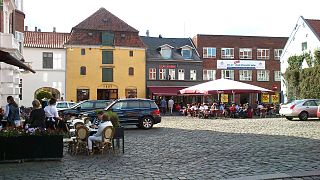
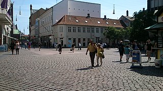
Store Torv is a public square located in the Indre By neighborhood in Aarhus, Denmark. It is situated between Lille Torv and Aarhus Cathedral, shaped as an elongated triangle. It is the largest public square in Aarhus and one of the oldest venues for markets in the city. The square is home to many notable buildings including the dominating cathedral and is frequently host to cultural events.
Lille Torv is a cobbled public square located in the Indre By neighborhood in Aarhus, Denmark. It is situated between the squares of Store Torv and Immervad in the historic Latin Quarter neighborhood and it is one of the oldest public squares in Aarhus. The streets of Vestergade, Guldsmedgade, Immervad and Badstuegade radiates from Lille Torv. It is today a venue for public events and gatherings in the city. The square is home to some notable buildings such as the storied Meulengracht's House and the listed Business- and Agricultural Bank of Jutland.
Graven is a street in Aarhus, Denmark. Graven was created some time before year 1500 on and in the northernmost moat used to defend the early Viking settlement. It is one of the oldest streets in the city and used to mark the northern city limits along with Klostergade. Graven runs 220 meter west to east from Klostergade to Mejlgade and is situated in the historic Latin Quarter neighborhood. Graven is fairly narrow and is a designated one-way street for motorized traffic in the direction of Mejlgade towards Klostergade. Graven is characterized by low housing, cafés and speciality shops, and has much foot and bicycle traffic. As Klostergade and Mejlgade, Graven is a shared bikeway, part of the city's bicycle infrastructure network.

Møllestien is a street in Aarhus, Denmark which runs west to east from Vester Allé to Grønnegade and intersects Møllegade roughly in the middle. The street is situated in the historic Indre By neighborhood and is known for its small houses and cobblestone pavement. The street has existed since before 1300 and the name has been used since the 15th century. The majority of the buildings in the street were constructed between 1870 and 1885.

Vesterbro Torv is a public square located in the Vesterbro neighborhood of Aarhus, Denmark. Vesterbro Torv is the junction where 8 street meet; Vesterbrogade, Hjortensgade, Langelandsgade, Teglværksgade, Nørre Allé, Vesterport, Vester Allé and Janus la Cours Gade. It is one of the most heavily trafficked areas in the city, receiving traffic from Åbyhøj and Brabrand in the west along Silkeborgvej and from Tilst in the north-west along Viborgvej. The square is designed as a central "island" surrounded by streets. The central part is primarily used for parking although there is a few recreational facilities such as public toilets and benches.