History
The city of Kuito is built in the historical heart of the Ovimbundu kingdom. The ruler of the Ovimbundu was named Viye and he married a Songo woman named Cahanda. Together they built the city and later the Portuguese would name the Bié Province after the ruler. [3] The Ovimbundu were known for selling captives from neighbouring tribes to the European slave traders which made the area an ideal location for the slave business and brought colonists to the area. The Portuguese "founded" the city in 1750. [4] They later called it Silva Porto after António da Silva Porto who built his home embala Belmonte in the area. [5] The pleasant climate in the Bié Province was attractive to Portuguese settlers and many made their home in Silva Porto in the early 1900s when the Benguela Railway connected the city to the coast.
Kuito had a long history of violence starting with the African slave trade and tribal warfare. Later in the 1960s the Portuguese used the town of Silva Porto as a training centre for training black Portuguese Army soldiers to send Northern Portuguese Angola in order to fight the nationalist guerrillas, during the Portuguese Colonial War.
After independence from Portugal in 1975, Kuito saw its worst times on 6 January 1993 when UNITA, during the Angolan Civil War, laid siege of the city for over 9 months and over 30,000 people were killed, both from war effects and starvation. Nobody was permitted to enter or leave the city for 9 months and the city suffered heavy damage. UNITA was eventually driven from Kuito and a second attempt was made to capture the city in 1998 using huge artillery and tanks. [6]

Luanda, formerly named São Paulo da Assunção de Loanda, is the capital and largest city in Angola, It is Angola's primary port, and its major industrial, cultural and urban centre. Located on Angola's northern coast with the Atlantic Ocean, Luanda is both Angola's chief seaport and its administrative centre. It is also the capital city of Luanda Province. Luanda and its metropolitan area is the most populous Portuguese-speaking capital city in the world, with over 8 million inhabitants in 2019. Among the oldest colonial cities of Africa, it was founded in January 1576 by Portuguese explorer Paulo Dias de Novais, under the name of São Paulo da Assunção de Loanda. The city served as the centre of the slave trade to Brazil before its prohibition. At the start of the Angolan Civil War in 1975, most of the white Portuguese left as refugees, principally for Portugal. Luanda's population increased greatly from refugees fleeing the war, but its infrastructure was inadequate to handle the increase. This also caused the exacerbation of slums, or musseques, around Luanda. The city is currently undergoing a major reconstruction, with many large developments taking place that will alter its cityscape significantly.
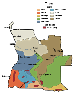
The culture of Angola is influenced by the Portuguese. Portugal occupied the coastal enclave Luanda, and later also Benguela, since the 16th/17th centuries, and expanded into the territory of what is now Angola in the 19th/20th centuries, ruling it until 1975. Both countries share cultural aspects: language (Portuguese) and main religion. However, the Angolan culture is mostly native Bantu, which was mixed with Portuguese culture. The diverse ethnic communities with their own cultural traits, traditions and native languages or dialects include the Ovimbundu, Ambundu, Bakongo, Chokwe, Avambo and other peoples.

Benguela is a province of Angola, situated in the west of the country. It lies on the Atlantic Ocean, and borders the provinces of Cuanza Sul, Namibe, Huila, and Huambo. The province has an area of 39,826 square kilometres (15,377 sq mi) and its capital is Benguela. According to 1988 US government statistics, the population had 297,700 urban inhabitants and 308,800 rural inhabitants, with an estimated total provincial population of 606,500. The current governor of Benguela is Isaac dos Anjos.

Cuanza Sul Province or Kwanza-Sul is a province of Angola. It has an area of 55,660 square kilometres (21,490 sq mi) and a population of 1,881,873. Sumbe is the capital of the province.

Huambo, formerly Nova Lisboa, is the capital of the province of Huambo in Angola. The city is located about 220 km E from Benguela and 600 km SE from Luanda. The city is, with a population of 575,000 (2014), the third largest in Angola after the capital city Luanda and Lubango. Huambo is a main hub on the Caminho de Ferro de Benguela (CFB), which runs from the port of Lobito to the Democratic Republic of the Congo's southernmost province, Katanga. Huambo is served by the Albano Machado Airport.

Malanje is the capital city of Malanje Province in Angola with a population of 455,000 (2014). It is located 380 kilometres (240 mi) east of Angola's capital Luanda. Near it are the spectacular Calandula waterfalls, the rock formations of Pungo Andongo, and the Capanda Dam. The climate is mainly humid, with average temperatures between 20 and 24 °C and rainfall 900 to 130 millimetres in the rainy season.
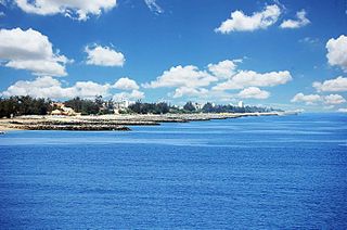
Lobito is a town, with a population of 357,950 (2014), and a municipality in Benguela Province in Angola. It is located on the Atlantic Coast north of Catumbela Estuary.

The Bié Plateau or Central Plateau of Angola is a plateau that occupies most of central Angola. The elevation of the plateau is from 1,520 m to 1,830 m.
The Bailundo revolt was an insurrection launched by the Ovimbundu kingdom of Bailundo and its allies against the Portuguese Empire. The revolt was prompted by the sudden decline of the price of root rubber, pitting the indigenous population against European immigrants and aboriginal loyalists. The revolt lasted between 1902 - 1904, ending in a Portuguese victory.

The following outline is provided as an overview of and topical guide to Angola:
Catabola is a town and municipality in Bié Province in central Angola. It is located 52.5 kilometres (32.6 mi) by road northeast of Kuito, on the road to Camacupa.
Kuito Airport is an airport serving Kuito, a city in the Bié Province in Angola.
The following is a timeline of the history of the city of Benguela, Angola.
This page is based on this
Wikipedia article Text is available under the
CC BY-SA 4.0 license; additional terms may apply.
Images, videos and audio are available under their respective licenses.
