Lake Preston, South Dakota

Last updated

Lake Preston, South Dakota
Kingsbury County South Dakota Incorporated and Unincorporated areas Lake Preston Highlighted.svg
Location in Kingsbury County and the state of South Dakota
Coordinates: 44°21′41″N97°22′33″W / 44.36139°N 97.37583°W / 44.36139; -97.37583
Country United States
State South Dakota
County Kingsbury
Incorporated1906 [1]
Area
[2]
  Total0.76 sq mi (1.97 km2)
  Land0.76 sq mi (1.97 km2)
  Water0.00 sq mi (0.00 km2)
Elevation
[3]
1,719 ft (524 m)
Population
 (2020) [4]
  Total589
  Density776.02/sq mi (299.55/km2)
Time zone UTC-6 (Central (CST))
  Summer (DST) UTC-5 (CDT)
ZIP codes
57233, 57249
Area code 605
FIPS code 46-35500 [5]
GNIS feature ID1267452 [3]

Lake Preston is a city in Kingsbury County, South Dakota, United States. The population was 599 at the 2010 census.

Contents

History

A post office called Preston was established in 1879, and the name was changed to Lake Preston in 1882. [6] The town site was platted in 1881. [7] It was located in the Dakota Territory at the time. The city took its name from nearby Lake Preston. [8]

Geography

According to the United States Census Bureau, the city has a total area of 0.76 square miles (1.97 km2), all land. [9]

Demographics

Historical population
CensusPop.Note
1890 337
1900 706109.5%
1910 1,00742.6%
1920 1,0080.1%
1930 944−6.3%
1940 886−6.1%
1950 9578.0%
1960 955−0.2%
1970 812−15.0%
1980 789−2.8%
1990 663−16.0%
2000 73711.2%
2010 599−18.7%
2020 589−1.7%
U.S. Decennial Census [10] [4]

2010 census

As of the census [11] of 2010, there were 599 people, 295 households, and 162 families residing in the city. The population density was 788.2 inhabitants per square mile (304.3/km2). There were 346 housing units at an average density of 455.3 per square mile (175.8/km2). The racial makeup of the city was 98.3% White, 0.3% Native American, 0.2% Asian, 0.5% from other races, and 0.7% from two or more races. Hispanic or Latino of any race were 1.2% of the population.

There were 295 households, of which 20.0% had children under the age of 18 living with them, 46.8% were married couples living together, 5.8% had a female householder with no husband present, 2.4% had a male householder with no wife present, and 45.1% were non-families. 40.7% of all households were made up of individuals, and 19.7% had someone living alone who was 65 years of age or older. The average household size was 2.03 and the average family size was 2.77.

The median age in the city was 47.6 years. 20.2% of residents were under the age of 18; 5.5% were between the ages of 18 and 24; 17.8% were from 25 to 44; 34.5% were from 45 to 64; and 21.9% were 65 years of age or older. The gender makeup of the city was 50.9% male and 49.1% female.

2000 census

As of the census [5] of 2000, there were 737 people, 317 households, and 183 families residing in the city. The population density was 999.0 inhabitants per square mile (385.7/km2). There were 355 housing units at an average density of 481.2 per square mile (185.8/km2). The racial makeup of the city was 98.91% White, 0.81% Native American, and 0.27% from two or more races. Hispanic or Latino of any race were 0.95% of the population.

There were 317 households, out of which 26.5% had children under the age of 18 living with them, 50.2% were married couples living together, 5.4% had a female householder with no husband present, and 42.0% were non-families. 38.8% of all households were made up of individuals, and 23.3% had someone living alone who was 65 years of age or older. The average household size was 2.15 and the average family size was 2.88.

In the city, the population was spread out, with 22.7% under the age of 18, 5.6% from 18 to 24, 23.5% from 25 to 44, 19.0% from 45 to 64, and 29.3% who were 65 years of age or older. The median age was 43 years. For every 100 females, there were 94.5 males. For every 100 females age 18 and over, there were 89.4 males.

The median income for a household in the city was $29,125, and the median income for a family was $42,143. Males had a median income of $29,750 versus $18,750 for females. The per capita income for the city was $16,426. About 6.5% of families and 8.1% of the population were below the poverty line, including 6.6% of those under age 18 and 15.0% of those age 65 or over.

In the media

Lake Preston is mentioned in the historical novel The Long Winter by American novelist Laura Ingalls Wilder. In the very severe winter of 1880–1881, a neighbor of Ingalls, David Gilbert, volunteered to make the very risky run from De Smet, South Dakota to Lake Preston (called, at that time, simply "Preston, Dakota Territory") to take outgoing mail and bring back the incoming mail. Though the distance was only about 12 miles, [12] the trip was dangerous because of blizzards coming up very quickly throughout that winter, and a person caught on the prairie during a blizzard had almost no chance of survival.

Notable people

Ora McMurry: Distinguished Service Cross, World War I [13]

Robert Wood: Wisconsin State Assembly [14]

See also

Related Research Articles

<span class="mw-page-title-main">Kingsbury County, South Dakota</span> County in South Dakota, United States

Kingsbury County is a county in the U.S. state of South Dakota. As of the 2020 census, the population was 5,187. Its county seat is De Smet. The county was created in 1873, and was organized in 1880. It was named for brothers George W. and T. A. Kingsbury, descendants of the colonial English Kingsbury family in Boston, Massachusetts. They were prominently involved in the affairs of Dakota Territory and served as elected members of several Territorial Legislatures.

<span class="mw-page-title-main">Walnut Grove, Minnesota</span> City in Minnesota, United States

Walnut Grove is a city in Redwood County, Minnesota, United States. The population was 871 at the 2010 census. Another name formerly associated with the area is Walnut Station.

<span class="mw-page-title-main">Hazen, North Dakota</span> City in North Dakota, United States

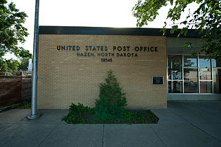
Hazen is a city in Mercer County, North Dakota, United States. The population was 2,281 at the 2020 census. Hazen was founded in 1913. Hazen has a K–12 school system.

<span class="mw-page-title-main">Spiritwood Lake, North Dakota</span> City in North Dakota, United States

Spiritwood Lake is a city in Stutsman County, North Dakota, United States. The population was 97 at the 2020 census.

<span class="mw-page-title-main">Scotland, South Dakota</span> City in South Dakota, United States

Scotland is a city in Bon Homme County, South Dakota, United States. Its population was 785 at the 2020 census.

<span class="mw-page-title-main">Mound City, South Dakota</span> Town in South Dakota, United States

Mound City is a town in and the county seat of Campbell County, South Dakota, United States. The population was 69 at the 2020 census.

<span class="mw-page-title-main">Platte, South Dakota</span> City in South Dakota, United States

Platte is a city in Charles Mix County, South Dakota, United States. The population was 1,311 at the 2022 census. The community is named after the Platte Creek, a tributary of the Missouri River reservoir Lake Francis Case. Platte is located 15 miles east of Lake Francis Case on the Missouri River.

<span class="mw-page-title-main">Willow Lake, South Dakota</span> City in South Dakota, United States

Willow Lake is a city in Clark County, South Dakota, United States. The population was 255 at the 2020 census.

<span class="mw-page-title-main">Clear Lake, South Dakota</span> City in South Dakota, United States

Clear Lake is a city in and the county seat of Deuel County, South Dakota, United States. The population was 1,218 at the 2020 census.

<span class="mw-page-title-main">Timber Lake, South Dakota</span> City in South Dakota, United States

Timber Lake is a city in and the county seat of Dewey County, South Dakota, United States. The population was 509 at the 2020 census.

<span class="mw-page-title-main">Big Stone City, South Dakota</span> City in South Dakota, United States

Big Stone City is a city in the northeastern corner of Grant County, South Dakota, United States, that lies between the southern tip of Big Stone Lake and the northern bank of the Whetstone River, and is adjacent to the city of Ortonville, Minnesota. The population was 412 at the 2020 census.

<span class="mw-page-title-main">Lake Norden, South Dakota</span> City in South Dakota, United States

Lake Norden is a city in Hamlin County, South Dakota, United States. It is part of the Watertown, South Dakota Micropolitan Statistical Area. The population was 554 at the 2020 census.

<span class="mw-page-title-main">Kadoka, South Dakota</span> City in South Dakota, United States

Kadoka is a city in and the county seat of Jackson County, South Dakota, United States. The population was 543 at the 2020 census. The town occupies about 2.3 square miles.

<span class="mw-page-title-main">De Smet, South Dakota</span> Town in South Dakota, United States

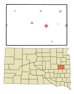
De Smet is a city in and the county seat of Kingsbury County, South Dakota, United States. The population was 1,056 at the 2020 census.

<span class="mw-page-title-main">Lake City, South Dakota</span> Town in South Dakota, United States

Lake City is a town in Marshall County, South Dakota, United States. The population was 45 at the 2020 census. Fort Sisseton Historic State Park, whose fort is listed on the National Register of Historic Places, is located nearby.

<span class="mw-page-title-main">Humboldt, South Dakota</span> Town in South Dakota, United States

Humboldt is a town in Minnehaha County, South Dakota, United States. The population was 579 at the 2020 census.

<span class="mw-page-title-main">Keystone, South Dakota</span> Town in South Dakota, United States

Keystone is a town in the Black Hills region of Pennington County, South Dakota, United States. The population was 240 at the 2020 census. It had its origins in 1883 as a mining town, and has since transformed itself into a resort town, serving the needs of the millions of visitors to the Mount Rushmore National Memorial, which is located just beyond the town limits. Keystone was heavily damaged in the 1972 Black Hills flood.

<span class="mw-page-title-main">Redfield, South Dakota</span> City in South Dakota, United States

Redfield is a city in and the county seat of Spink County, South Dakota, United States. The population was 2,214 at the 2020 census. The city was named for J. B. Redfield, a railroad official.

<span class="mw-page-title-main">Hamill, South Dakota</span> CDP in South Dakota, United States

Hamill is a rural hamlet in Tripp County, South Dakota, United States. The population was 14 at the 2020 census. There is a post office at Hamill, also two churches and a community hall; otherwise, no businesses or services.

<span class="mw-page-title-main">Jefferson, South Dakota</span> City in South Dakota, United States

Jefferson is a city in Union County, South Dakota, United States. The population was 475 at the 2020 census. It is part of the Sioux City, IA-NE-SD Metropolitan Statistical Area. Jefferson was founded in 1859. Every year the citizens of Jefferson and surrounding area celebrate the founding of Jefferson during "Jefferson Days", a festival that includes a movie in the park, a car show, fireworks and parade.

References

  1. "SD Towns" (PDF). South Dakota State Historical Society. Archived from the original (PDF) on February 10, 2010. Retrieved February 14, 2010.
  2. "ArcGIS REST Services Directory". United States Census Bureau. Retrieved October 15, 2022.
  3. 1 2 U.S. Geological Survey Geographic Names Information System: Lake Preston, South Dakota
  4. 1 2 "Census Population API". United States Census Bureau. Retrieved October 15, 2022.
  5. 1 2 "American FactFinder". United States Census Bureau . Retrieved January 31, 2008.
  6. "Kingsbury County". Jim Forte Postal History. Retrieved March 21, 2015.
  7. Federal Writers' Project (1940). South Dakota place-names, v.1-3. University of South Dakota. p. 47.
  8. Chicago and North Western Railway Company (1908). A History of the Origin of the Place Names Connected with the Chicago & North Western and Chicago, St. Paul, Minneapolis & Omaha Railways. p. 92.
  9. "US Gazetteer files 2010". United States Census Bureau. Archived from the original on February 20, 2011. Retrieved June 21, 2012.
  10. United States Census Bureau. "Census of Population and Housing". Archived from the original on May 7, 2015. Retrieved June 13, 2016.
  11. "American FactFinder". United States Census Bureau . Retrieved June 21, 2012.
  12. Wilder, Laura Ingalls (March 27, 2014). The Long Winter. Mustbe Interactive. p. 148.
  13. "Ora R. McMurry : Place of Birth: South Dakota, Lake Preston : Home of record: Evansville Wisconsin". Militarytimes.com. Retrieved January 14, 2015. Lieutenant McMurry was credited with 3 aerial victories in World War I
  14. "Biographical: U. S. senators, state officers, supreme court judges, state senators, members of assembly". University of Wisconsin Digital Collections. Retrieved December 4, 2015.