
Walworth County is a county located in the U.S. state of Wisconsin. As of the 2020 census, the population was 106,478. Its county seat is Elkhorn. The county was created in 1836 from Wisconsin Territory and organized in 1839. It is named for Reuben H. Walworth. Walworth County comprises the Whitewater-Elkhorn, WI Micropolitan Statistical Area and is included in the Milwaukee-Racine-Waukesha, WI Combined Statistical Area. Lake Geneva, the University of Wisconsin-Whitewater, and Alpine Valley Resort, and Music Theatre are located in Walworth County.

Outagamie County is a county in the Fox Cities region of the U.S. state of Wisconsin, located in the northeast of the state. As of the 2020 Census, the population was 190,705. Its county seat is Appleton.

Kenosha County is located in the southeastern corner of the U.S. state of Wisconsin. The population was 169,151 as of the 2020 census, making it the eighth-most populous county in Wisconsin. The county shares the same name as its county seat, the city of Kenosha, the fourth-largest city in Wisconsin.

Kenosha is a city in and the seat of Kenosha County, Wisconsin, United States. Per the 2020 census, the population was 99,986, which made it the fourth-most populous city in Wisconsin. Situated on the southwestern shore of Lake Michigan, Kenosha is a satellite city located roughly 40 miles (64 km) south of Milwaukee and 66 miles (106 km) north of Chicago and has significant cultural and economic connections to both cities. Interstate 94 runs along Kenosha's western border.

Pleasant Prairie is a village in the U.S. state of Wisconsin. Located in Kenosha County along the southwestern shoreline of Lake Michigan, Pleasant Prairie was home to 21,250 people at the 2020 census. The village is positioned directly south of the city of Kenosha and directly north of the Illinois border.

Somers is a village in Kenosha County, Wisconsin, United States. The population was 8,402 at the 2020 census. Somers has a post office with ZIP code 53171. The former unincorporated communities of Berryville, Central Park, and Kellogg's Corners are located in the village.

Wheatland is a town in Kenosha County, Wisconsin, United States. The population was 3,391 at the 2020 census. The census-designated place of Powers Lake is located partially in the town. The unincorporated communities of Lily Lake, New Munster, and Slades Corners are also located in the town.

Charles H. Durkee was an American pioneer, Congressman, and United States Senator from Wisconsin. He was one of the founders of Kenosha, Wisconsin, and was a Governor of the Utah Territory in the last five years of his life.

Kenosha Light Station is a lighthouse and keeper's house on Simmons Island north of the channel into Kenosha's harbor in Kenosha County, Wisconsin.
Klondike is an unincorporated residential and agricultural community in the town of Brighton, in Kenosha County, Wisconsin, United States.
Chapin is a small residential and agricultural unincorporated community in the town of Paris, Kenosha County, Wisconsin, United States. It is centered at Highway 142 near what is currently Kenosha County Highway MB. The community was settled in the 19th century and has also been known as Star Corners, Heidersdorf's Corner, Jugville, and Parisville.
Paris is a small unincorporated community in north-central Kenosha County, Wisconsin, United States, located at U.S. Route 45 and Wisconsin Highway 142 in the town of Paris. The name was chosen by 19th century settler Seth Butler Myrick in honor of the town of his birth in Oneida County, New York. Paris is the site of the Paris Corners town cemetery. The area once had the nickname "Tar Corners", after an incident where a dispute between neighbors led to a tarring and feathering. A post office opened in 1845, closing in 1903.
Truesdell is a residential and business neighborhood of the city of Kenosha in east-central Kenosha County, Wisconsin, United States. It lies along Highway 50 on the former Milwaukee Road main railroad line from Chicago, Illinois. The last Milwaukee Road passenger trains stopped in Truesdell in 1945, but there are still switching facilities present. The community was settled by Gideon and Julia Truesdell in the 19th century, but the community itself has disappeared within the city of Kenosha and related surrounding development, though some businesses still identify with the original name. The Truesdell post office, organized in 1870, closed on May 1, 1953; its postmistress, Mrs. Jennie H. Alsted, had operated it from her home's back porch for 31 years.

Slades Corners is a small unincorporated residential and agricultural community located on Old Highway 50 and 400th Avenue in the western Kenosha County, Wisconsin town of Wheatland. Slades Corners is named for Tom Slade, an early resident who settled 640 acres (2.6 km2) there in approximately 1840, eight years before Wisconsin statehood.

State Trunk Highway 50 is a 44.43-mile (71.50 km) state highway in Walworth and Kenosha counties in Wisconsin, United States, that runs from Wisconsin Highway 11 (WIS 11) in Delavan east to Wisconsin Highway 32 (WIS 32) in Kenosha. The highway is maintained by the Wisconsin Department of Transportation.
Wisconsin's 1st congressional district is a congressional district of the United States House of Representatives in southeastern Wisconsin, covering Kenosha County, Racine County, and most of Walworth County, as well as portions of Rock County and Milwaukee County. The district's current Representative is Republican Bryan Steil.

Richard I. Bong Air Force Base is an unfinished Air Force base. It was named after World War II aviator Major Richard Ira Bong. The base was intended to be an air defense fighter base for the Chicago and Milwaukee areas. It was conceived in the early 1950s and construction began in the mid-1950s. Construction had barely begun when the base was transferred to the Strategic Air Command. Eventually, the base was considered obsolete as it had become apparent to Air Force officials that the base would be redundant with installations nearby that would soon have space for more units. The base was abandoned in 1959 and disposed of the following year.
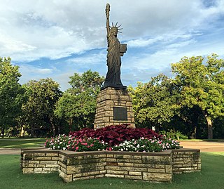
Strengthen the Arm of Liberty is the theme of the Boy Scouts of America's fortieth anniversary celebration in 1950. The campaign was inaugurated in 1949 with a dramatic ceremony held at the base of the Statue of Liberty. Approximately 200 BSA Statue of Liberty replicas were installed across the United States.

Bristol is a village in Kenosha County, Wisconsin, United States. It was incorporated in 2009 from portions of the Town of Bristol. The population was 5,192 at the 2020 census, more than double the 2010 census population of 2,584. The former unincorporated communities of Bissell, Cypress, Pikeville, and Woodworth are located in the village.
Salem is a community in the village of Salem Lakes, Kenosha County, Wisconsin, United States. The community is located on Wisconsin Highway 83 1.5 miles (2.4 km) south of Paddock Lake. Salem has a post office with ZIP code 53168.


