Wheatland, Kenosha County, Wisconsin

Last updated

Town of Wheatland, Wisconsin
WIMap-doton-Wheatland.png
Location of the Town of Wheatland, Wisconsin
Coordinates: 42°34′37″N88°13′35″W / 42.57694°N 88.22639°W / 42.57694; -88.22639
Country Flag of the United States.svg  United States
State Flag of Wisconsin.svg  Wisconsin
County Kenosha
Area
  Total24.1 sq mi (62.3 km2)
  Land23.7 sq mi (61.5 km2)
  Water0.3 sq mi (0.8 km2)
Elevation
[1]
807 ft (246 m)
Population
 (2010)
  Total3,373
  Density142/sq mi (54.9/km2)
Time zone UTC-6 (Central (CST))
  Summer (DST) UTC-5 (CDT)
Area code 262
FIPS code 55-86500 [2]
GNIS feature ID1584421 [1]
Website townwheatland.com

Wheatland is a town in Kenosha County, Wisconsin, United States. The population was 3,391 at the 2020 census. The census-designated place of Powers Lake is located partially in the town. The unincorporated communities of Lily Lake, New Munster, and Slades Corners are also located in the town.

Contents

Settlement in the town is centered along 328th Avenue (Kenosha County Highway W) north of 60th Street (Kenosha County Highway K). [3] The former Wisconsin Central Railway Chicago-Twin Cities main line (now the Canadian National Railway) also runs through the town; a passenger and freight station used was located here well into the 20th century.[ citation needed ]

Geography

According to the United States Census Bureau, the town has a total area of 24.1 square miles (62.3 km2), of which 23.7 square miles (61.5 km2) are land and 0.3 square miles (0.8 km2), or 1.36%, are water. [4]

History

The first settlers in Wheatland were Schuyler Bonday in August 1837 and Adolph Reitbrook in September 1837. Wheatland was formed on May 7, 1842. Its name is derived from the wheat which was said to grow well in the rich soil in the area. The first constable was James B. Powers, for whom Powers Lake is named.

When the Town of Wheatland was formed, it was originally in Racine County. On January 30, 1850, the town was transferred to Kenosha County, where it remains today. [5]

Demographics

Historical population
CensusPop.Note
2000 3,292
2010 3,3732.5%
2020 3,3910.5%
U.S. Decennial Census [6]

As of the census [2] of 2000, there were 3,292 people, 1,209 households, and 893 families residing in the town. The population density was 139.8 inhabitants per square mile (54.0/km2). There were 1,379 housing units at an average density of 58.6 per square mile (22.6/km2). The racial makeup of the town was 98.12% White, 0.49% African American, 0.21% Native American, 0.24% Asian, 0.27% from other races, and 0.67% from two or more races. Hispanic or Latino of any race were 0.97% of the population.

There were 1,209 households, out of which 36.0% had children under the age of 18 living with them, 60.0% were married couples living together, 9.5% had a female householder with no husband present, and 26.1% were non-families. 20.7% of all households were made up of individuals, and 7.1% had someone living alone who was 65 years of age or older. The average household size was 2.72 and the average family size was 3.15.

In the town, the population was spread out, with 26.9% under the age of 18, 8.1% from 18 to 24, 30.3% from 25 to 44, 25.3% from 45 to 64, and 9.4% who were 65 years of age or older. The median age was 37 years. For every 100 females, there were 104.6 males. For every 100 females age 18 and over, there were 99.3 males.

The median income for a household in the town was $52,386, and the median income for a family was $61,797. Males had a median income of $43,000 versus $27,917 for females. The per capita income for the town was $21,299. About 3.5% of families and 5.3% of the population were below the poverty line, including 3.2% of those under age 18 and 5.9% of those age 65 or over.

January 2008 tornado

A tornado touched down in the town on January 7, 2008. The tornado was rated EF3 on the Enhanced Fujita Scale, with winds estimated at 140-150 mph. [7] Its path covered 10.8 miles (17.4 km) [7] and was 200 yards (180 m) wide, demolishing 25 houses and damaging about 100 more. [8] This left 160 people homeless or unable to return to their homes. [7] The damage was estimated at $18 million. [9]

Related Research Articles

<span class="mw-page-title-main">Racine County, Wisconsin</span> County in Wisconsin, United States

Racine County is a county in southeastern Wisconsin. As of the 2020 census, its population was 197,727, making it Wisconsin's fifth-most populous county. Its county seat is Racine. The county was founded in 1836, then a part of the Wisconsin Territory. Racine County comprises the Racine metropolitan statistical area. This area is part of the Milwaukee-Racine-Waukesha combined statistical area. According to the U.S. Census Bureau, the county has an area of 792 square miles (2,050 km2), of which 333 square miles (860 km2) is land and 460 square miles (1,200 km2) (58%) is water. The county's unemployment rate was 5.6% in June 2021.

<span class="mw-page-title-main">Kenosha County, Wisconsin</span> County in Wisconsin, United States

Kenosha County is located in the southeastern corner of the U.S. state of Wisconsin. The population was 169,151 as of the 2020 census, making it the eighth most populous county in Wisconsin. The county shares the same name as its county seat, the city of Kenosha, the fourth largest city in Wisconsin. Kenosha County is part of the Chicago metropolitan area, the fourth most-populous metropolitan area in North America. Kenosha County is situated on the southwestern shore of Lake Michigan.

<span class="mw-page-title-main">Sheldon, New York</span> Town in New York, United States

Sheldon is an incorporated town in Wyoming County, New York. The population was 2,409 at the 2010 census. The Town of Sheldon is on the west border of Wyoming County. The town is southeast of Buffalo.

<span class="mw-page-title-main">Masury, Ohio</span> Census-designated place in Ohio, United States

Masury is an unincorporated community and census-designated place in eastern Trumbull County, Ohio, United States. The population was 2,001 at the 2020 census. It is part of the Youngstown–Warren metropolitan area.

<span class="mw-page-title-main">Mount Pleasant, Green County, Wisconsin</span> Town in Wisconsin, United States

Mount Pleasant is a town in Green County, Wisconsin, in the United States. As of the 2000 census, its population was 547. The unincorporated community of Schultz is located partially in the town.

<span class="mw-page-title-main">Brighton, Kenosha County, Wisconsin</span> Town in Wisconsin, United States

The Town of Brighton is a town located in Kenosha County, Wisconsin, United States. The population was 1,422 at the 2020 census. The unincorporated communities of Brighton and Klondike are located within the town.

<span class="mw-page-title-main">Bristol (town), Kenosha County, Wisconsin</span> Former Town in Wisconsin, United States

The Town of Bristol is a former town in Kenosha County, Wisconsin, United States. The population was 4,538 at the 2000 census—before a portion of the town was incorporated as the Village of Bristol. The remainder of the Town of Bristol was annexed by the Villages of Bristol and Pleasant Prairie effective July 4, 2010, and the town ceased to exist.

<span class="mw-page-title-main">Paris, Kenosha County, Wisconsin</span> Town in Wisconsin, United States

Paris is a town in Kenosha County, Wisconsin, United States. The population was 1,397 at the 2020 census. The unincorporated communities of Chapin and Paris are located within the town.

<span class="mw-page-title-main">Randall, Wisconsin</span> Town in Wisconsin, United States

Randall is a town in Kenosha County, Wisconsin, United States. The population was 3,285 at the 2020 census. The unincorporated community of Bassett and census-designated place of Powers Lake are located in Randall, and the town surrounds the village of Twin Lakes, a separate municipality.

<span class="mw-page-title-main">Salem Lakes, Wisconsin</span> Village in Wisconsin, United States

Salem Lakes, formerly the town of Salem and the village of Silver Lake, is a village in Kenosha County, Wisconsin, United States. The village was created by a municipal merger on February 14, 2017. The population was 14,601 at the 2020 census. The communities of Benet Lake, Camp Lake, Cross Lake, Fox River, Lake Shangrila, Liberty Corners, Salem, Salem Oaks, Silver Lake, Trevor, Voltz Lake, and Wilmot are wholly or partially located in the village.

<span class="mw-page-title-main">Dover, Racine County, Wisconsin</span> Town in Wisconsin, United States

The Town of Dover is located in Racine County, Wisconsin, United States. The population was 4,282 at the 2020 census. The unincorporated communities of Beaumont, Eagle Lake Manor, Eagle Lake Terrace, Kansasville, and Rosewood are located in the town. The census-designated place of Eagle lake is also located in the town.

<span class="mw-page-title-main">Eagle Lake, Wisconsin</span> CDP in Wisconsin, United States

Eagle Lake is a census-designated place (CDP) in the town of Dover, Racine County, Wisconsin, United States. The population was 1,251 at the 2020 census.

<span class="mw-page-title-main">Mount Pleasant, Wisconsin</span> Village in Wisconsin, United States

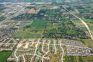
Mount Pleasant is a village in Racine County, Wisconsin, United States. It is located approximately 30 miles south of Milwaukee and 60 mi (97 km) north of Chicago. As of the 2020 census, the village's population was 27,732.

<span class="mw-page-title-main">Raymond, Wisconsin</span> Village in Wisconsin, United States

Raymond is a village in Racine County, Wisconsin, United States. The population was 3,926 at the 2020 census. The unincorporated communities of Kneeland and Raymond are located in the town, as was the ghost town of Raymond Center. The unincorporated communities of North Cape and Union Church are also located partially in the town.

<span class="mw-page-title-main">Sturtevant, Wisconsin</span> Village in Wisconsin, United States

Sturtevant is a village in Racine County, Wisconsin, United States. The population was 6,919 at the 2020 census.

<span class="mw-page-title-main">Yorkville, Wisconsin</span> Village in Wisconsin, United States

Yorkville is a town in Racine County, Wisconsin, United States. The population was 3,246 at the 2020 census. The unincorporated communities of Ives Grove, Sylvania, and Yorkville are located in the town.

<span class="mw-page-title-main">Wheatland, Vernon County, Wisconsin</span> Town in Vernon County, Wisconsin, United States

Wheatland is a town in Vernon County, Wisconsin, United States. The population was 533 at the 2000 census. The unincorporated communities of Red Mound, and Victory are located in Wheatland.

<span class="mw-page-title-main">Powers Lake, Wisconsin</span> Census-designated place in Wisconsin, United States

Powers Lake is a census-designated place (CDP) in the towns of Randall and Wheatland, in Kenosha County in the U.S. state of Wisconsin. As of the 2020 census, the CDP had a population of 1,401. Part of the Powers Lake CDP was in Walworth County, but on December 20, 2011, it became part of the village of Bloomfield.

Oakfield is a town in Fond du Lac County, Wisconsin, United States. The population was 767 at the 2000 census. The Village of Oakfield is located within the town. The unincorporated community of Oak Center is also located in the town.

<span class="mw-page-title-main">Eagle (town), Wisconsin</span> Town in Wisconsin, United States

Eagle is a town in Waukesha County, Wisconsin, United States. The population was 3,478 at the 2020 census. The Village of Eagle is located within the town. The unincorporated community of Eagleville is also located in the town.

References

  1. 1 2 "US Board on Geographic Names". United States Geological Survey. October 25, 2007. Retrieved January 31, 2008.
  2. 1 2 "U.S. Census website". United States Census Bureau . Retrieved January 31, 2008.
  3. U.S. Geological Survey Geographic Names Information System: Wheatland (community), Wisconsin
  4. "Geographic Identifiers: 2010 Census Summary File 1 (G001), Wheatland town, Kenosha County, Wisconsin". American FactFinder. U.S. Census Bureau. Archived from the original on February 13, 2020. Retrieved August 6, 2019.
  5. Wheatland, Town of, Kenosha Co
  6. "Census of Population and Housing". Census.gov. Retrieved June 4, 2016.
  7. 1 2 3 Held, Tom; Jones, Meg (January 8, 2008). "In a tornado's wake". JSOnline.com. Milwaukee Journal Sentinel. Retrieved January 9, 2008.
  8. Einhorn, Catrin (January 9, 2008). "Storms Strike Midwest, Killing at Least 6". The New York Times . Retrieved January 9, 2008.
  9. DeLong, Katie (January 11, 2008). "Tornado Damage Estimate Up To $18 Million". TodaysTMJ4.com. The Associated Press. Retrieved January 11, 2008.