Paddock Lake, Wisconsin

Last updated

Paddock Lake, Wisconsin
Kenosha County Wisconsin Incorporated and Unincorporated areas Paddock Lake Highlighted.svg
Location of Paddock Lake in Kenosha County, Wisconsin.
Coordinates: 42°34′27″N88°6′19″W / 42.57417°N 88.10528°W / 42.57417; -88.10528
Country Flag of the United States.svg  United States
State Flag of Wisconsin.svg  Wisconsin
County Kenosha
Area
[1]
  Total3.11 sq mi (8.05 km2)
  Land2.90 sq mi (7.51 km2)
  Water0.21 sq mi (0.54 km2)
Elevation
[2]
817 ft (249 m)
Population
 (2020) [3]
  Total2,919
  Density1,074.48/sq mi (414.87/km2)
Demonym Paddock Laker
Time zone UTC-6 (Central (CST))
  Summer (DST) UTC-5 (CDT)
Area code 262
FIPS code 55-60975 [4]
GNIS feature ID1570989 [2]
Website www.paddocklake.net

Paddock Lake is a village in Kenosha County, Wisconsin, United States. The population was 2,919 at the 2020 census.

Contents

Geography

Paddock Lake is located at 42°34′27″N88°6′19″W / 42.57417°N 88.10528°W / 42.57417; -88.10528 (42.574094, -88.105210). [5]

According to the United States Census Bureau, the village has a total area of 3.10 square miles (8.03 km2), of which, 2.86 square miles (7.41 km2) of it is land and 0.24 square miles (0.62 km2) is water. [6]

Demographics

Historical population
CensusPop.Note
1970 1,470
1980 2,20750.1%
1990 2,66220.6%
2000 3,01213.1%
2010 2,992−0.7%
2020 2,919−2.4%
U.S. Decennial Census [7]

2010 census

As of the census [3] of 2010, there were 2,992 people, 1,125 households, and 831 families living in the village. The population density was 1,046.2 inhabitants per square mile (403.9/km2). There were 1,297 housing units at an average density of 453.5 per square mile (175.1/km2). The racial makeup of the village was 95.5% White, 0.5% African American, 0.5% Native American, 0.3% Asian, 0.1% Pacific Islander, 1.4% from other races, and 1.7% from two or more races. Hispanic or Latino of any race were 5.2% of the population.

There were 1,125 households, of which 37.2% had children under the age of 18 living with them, 56.1% were married couples living together, 11.1% had a female householder with no husband present, 6.7% had a male householder with no wife present, and 26.1% were non-families. 20.5% of all households were made up of individuals, and 6.5% had someone living alone who was 65 years of age or older. The average household size was 2.66 and the average family size was 3.06.

The median age in the village was 37.8 years. 24.7% of residents were under the age of 18; 9.1% were between the ages of 18 and 24; 27.6% were from 25 to 44; 30.4% were from 45 to 64; and 8.4% were 65 years of age or older. The gender makeup of the village was 50.3% male and 49.7% female.

2000 census

As of the census [4] of 2000, there were 3,012 people, 1,056 households, and 803 families living in the village. The population density was 1,539.9 inhabitants per square mile (594.6/km2). There were 1,185 housing units at an average density of 605.8 per square mile (233.9/km2). The racial makeup of the village was 96.85% White, 0.40% African American, 0.17% Native American, 0.70% Asian, 0.03% Pacific Islander, 0.93% from other races, and 0.93% from two or more races. Hispanic or Latino of any race were 4.48% of the population.

There were 1,056 households, out of which 42.3% had children under the age of 18 living with them, 60.7% were married couples living together, 10.7% had a female householder with no husband present, and 23.9% were non-families. 17.9% of all households were made up of individuals, and 6.1% had someone living alone who was 65 years of age or older. The average household size was 2.84 and the average family size was 3.24.

In the village, the population was spread out, with 29.9% under the age of 18, 7.9% from 18 to 24, 33.7% from 25 to 44, 20.6% from 45 to 64, and 8.0% who were 65 years of age or older. The median age was 34 years. For every 100 females, there were 105.2 males. For every 100 females age 18 and over, there were 102.2 males.

The median income for a household in the village was $53,382, and the median income for a family was $60,216. Males had a median income of $40,757 versus $28,229 for females. The per capita income for the village was $20,621. About 0.7% of families and 1.5% of the population were below the poverty line, including none of those under age 18 and 2.5% of those age 65 or over.

Education

Paddock Lake is the home of the regional high school, Westosha Central High School.

Notable people

Related Research Articles

<span class="mw-page-title-main">Forestdale, Alabama</span> Unincorporated community in Alabama, United States

Forestdale is an unincorporated community and census-designated place (CDP) in Jefferson County, Alabama, United States. It is north of the Birmingham city neighborhood of Ensley. At the 2020 census, the population was 10,409.

<span class="mw-page-title-main">Pepeekeo, Hawaii</span> Census-designated place in Hawaii, U.S.

Pepeekeo is a census-designated place (CDP) in Hawaii County, Hawaii, United States. The population was 1,789 at the 2010 census, up from 1,697 at the 2000 census.

Paddock Township is a township in Otter Tail County, Minnesota, United States. The population was 323 at the 2000 census.

<span class="mw-page-title-main">Miramiguoa Park, Missouri</span> Village in Missouri, United States

Miramiguoa Park is a village in Franklin County, Missouri, United States. The population was 120 at the 2010 census.

<span class="mw-page-title-main">Country Life Acres, Missouri</span> Village in Missouri, United States

Country Life Acres is a village in St. Louis County, Missouri, United States. The population was 72 at the 2020 census.

<span class="mw-page-title-main">Fleming, New York</span> Town in New York, United States

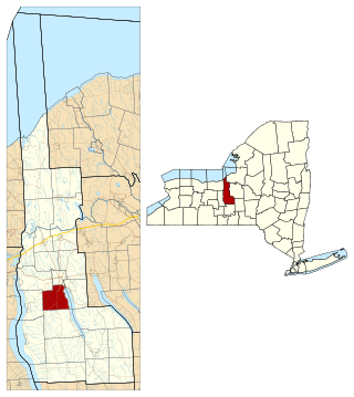
Fleming is a town in Cayuga County, New York, United States. The population was 2,475 at the 2020 census. The name is that of General George Fleming, an early settler. Fleming is at the northern end of Owasco Lake, south of Auburn.

<span class="mw-page-title-main">Wayne Lakes, Ohio</span> Village in Ohio, United States

Wayne Lakes is a village in Darke County, Ohio, United States. The population was 693 at the 2020 census.

<span class="mw-page-title-main">Addyston, Ohio</span> Village in Ohio, United States

Addyston is a village in Miami Township, Hamilton County, Ohio, United States. Located along the Ohio River, it is a western suburb of the neighboring city of Cincinnati. The population was 927 at the 2020 census.

<span class="mw-page-title-main">Darbyville, Ohio</span> Village in Ohio, United States

Darbyville is a village in Pickaway County, Ohio, United States. The population was 186 at the 2020 census.

<span class="mw-page-title-main">Lakeside, San Patricio County, Texas</span> Town in Texas, United States

Lakeside is a town in San Patricio County, Texas, United States. As of the 2010 census, the town population was 312.

<span class="mw-page-title-main">Kekoskee, Wisconsin</span> Village in Wisconsin, United States

Kekoskee is a village in Dodge County, Wisconsin, United States. The population was 161 at the 2010 census.

<span class="mw-page-title-main">Browntown, Wisconsin</span> Village in Wisconsin, United States

Browntown is a village in Green County, Wisconsin, United States. The population was 280 at the 2010 census.

<span class="mw-page-title-main">Markesan, Wisconsin</span> City in Wisconsin, United States

Markesan is a city in Green Lake County, Wisconsin, United States. The population was 1,476 at the 2010 census. The center of population of Wisconsin is located in Markesan.

<span class="mw-page-title-main">Salem Lakes, Wisconsin</span> Village in Wisconsin, United States

Salem Lakes, formerly the town of Salem and the village of Silver Lake, is a village in Kenosha County, Wisconsin, United States. The village was created by a municipal merger on February 14, 2017. The population was 14,601 at the 2020 census. The communities of Benet Lake, Camp Lake, Cross Lake, Fox River, Lake Shangrila, Liberty Corners, Salem, Salem Oaks, Silver Lake, Trevor, Voltz Lake, and Wilmot are wholly or partially located in the village.

<span class="mw-page-title-main">Bay City, Wisconsin</span> Village in Wisconsin, United States

Bay City is a village on the Mississippi River in Pierce County, Wisconsin, United States. The population was 500 at the 2010 census.

<span class="mw-page-title-main">Weyerhaeuser, Wisconsin</span> Village in Wisconsin, United States

Weyerhaeuser is a village in Rusk County, Wisconsin, United States. The population was 238 at the 2010 census.

<span class="mw-page-title-main">Verona, Ohio</span> Village in Ohio, United States

Verona is a village in Montgomery and Preble counties in the U.S. state of Ohio. The population was 403 at the 2020 census. It is part of the Dayton Metropolitan Statistical Area.

<span class="mw-page-title-main">Dorchester, Wisconsin</span> Village in Wisconsin, United States

Dorchester is a village in Clark and Marathon counties in the U.S. state of Wisconsin, along the 45th parallel. It is part of the Wausau, Wisconsin Metropolitan Statistical Area. The population was 876 at the 2010 census. Of this, 871 were in Clark County, and only 5 were in Marathon County.

<span class="mw-page-title-main">Bloomington, Wisconsin</span> Village in Wisconsin, United States

Bloomington is a village in Grant County, Wisconsin, United States. The population was 735 as of the 2010 census. The village is located within the Town of Bloomington.

<span class="mw-page-title-main">La Valle, Wisconsin</span> Village in Wisconsin, United States

La Valle is a village in Sauk County, Wisconsin, United States, along the Baraboo River. The population was 367 at the 2010 census. The village is located within the Town of La Valle.

References

  1. "2019 U.S. Gazetteer Files". United States Census Bureau. Retrieved August 7, 2020.
  2. 1 2 "US Board on Geographic Names". United States Geological Survey. October 25, 2007. Retrieved January 31, 2008.
  3. 1 2 "U.S. Census website". United States Census Bureau . Retrieved November 18, 2012.
  4. 1 2 "U.S. Census website". United States Census Bureau . Retrieved January 31, 2008.
  5. "US Gazetteer files: 2010, 2000, and 1990". United States Census Bureau. February 12, 2011. Retrieved April 23, 2011.
  6. "US Gazetteer files 2010". United States Census Bureau. Archived from the original on January 25, 2012. Retrieved November 18, 2012.
  7. "Census of Population and Housing". Census.gov. Retrieved June 4, 2015.