List of U.S. Highways in Illinois

Last updated

United States Numbered Highway System in Illinois

US 6.svg

US 45.svg

US 150.svg

Standard Illinois U.S. Highway markers
System information
Maintained by IDOT, ISTHA, and CDOT
FormedNovember 11, 1926 (1926-11-11) [1]
Highway names
Interstates Interstate X (I-X)
US Highways U.S. Route X (US X)
State Illinois Route X (IL X)
System links

This is a list of U.S. Highways in Illinois, all of which are owned and maintained by the U.S. state of Illinois. The Illinois Department of Transportation (IDOT) is responsible for maintaining the U.S Highways in Illinois. The system in Illinois consists of 20 primary highways.

Contents

Mainline highways

NumberLength (mi) [2] Length (km)Southern or western terminusNorthern or eastern terminusFormedRemovedNotes
US 6.svg US 6 179.88289.49 I-74/US 6 in Moline I-80/I-94/US 6 in Lansing 01932-01-011932currentGrand Army of the Republic Highway
US 12.svg US 12 85.14137.02 US 12 near Richmond US 12/US 20/US 41 in Chicago 01928-01-011928current
US 14.svg US 14 69.55111.93 US 14 near Harvard US 41 in Chicago 01933-01-011933currentRonald Reagan Highway / Northwest Highway
US 20.svg US 20 233.93376.47 US 20 in East Dubuque US 12/US 20/US 41 in Chicago 01926-01-011926currentUlysses S. Grant Memorial Highway
US 24.svg US 24 255.13410.59 US 24 in Quincy US 24/US 52 in Sheldon 01926-01-011926current
US 30.svg US 30 153.79247.50 US 30 in Fulton US 30 in Lynwood 01926-01-011926current
US 32 (1926).svg US 32 US 6 at Moline US 41 in Chicago 01926-01-01192601934-01-011934Now US 6 and US 34
US 34.svg US 34 211.37340.17 US 34 in Gladstone IL 43 in Berwyn 01926-01-011926currentWalter Payton Memorial Highway
US 36.svg US 36 216.47348.37 I-72/US 36/Route 110 in Hull US 36 in Chrisman 01926-01-011926current
US 40.svg US 40 159.99257.48 I-55/I-64/US 40 in East St. Louis I-70/US 40 near Marshall 01926-01-011926current National Road
US 41.svg US 41 64.81104.30 US 12/US 20/US 41 in Chicago I-94/US 41 near Russell 01926-01-011926currentBrian Piccolo Memorial Highway
US 45.svg US 45 428.99690.39 US 45 near Brookport US 45 near Antioch 01926-01-011926current
US 50.svg US 50 165.79266.81 I-255/US 50 in Columbia US 50 in Lawrenceville 01926-01-011926current
US 51.svg US 51 415.95669.41 US 51/US 60/US 62 at Cairo US 51 in South Beloit 01926-01-011926current
US 52.svg US 52 216348 US 52/Iowa 64 in Savanna US 24/US 52 in Sheldon 01926-01-011926current
US 54.svg US 54 23.9638.56 US 54 near Pittsfield I-72/US 36 near Pittsfield01926-01-011926current
US 60.svg US 60 0.921.48 US 60/US 62 at Cairo US 51/US 60/US 62 at Cairo01926-01-011926currentConcurrent with US 62
US 61.svg US 61 2.423.89 US 61/US 151 at East Dubuque US 61/US 151 at East Dubuque01971-01-01197101982-01-011982Concurrent with US 151
US 62.svg US 62 0.921.48 US 60/US 62 at Cairo US 51/US 60/US 62 at Cairo01926-01-011926currentConcurrent with US 60
US 66.svg US 66 301484 US 66 at East St. Louis US 41 in Chicago 01926-01-01192601974-01-011974Will Rogers Highway / Mother Road
US 67.svg US 67 213.99344.38 US 67 in Alton US 67 in Rock Island 01926-01-011926current
US 124 (1926).svg US 124 8013001926-01-01192601938-01-011938
US 136.svg US 136 225.95363.63 US 136 at Hamilton US 136 at Danville 01926-01-011926current
US 150.svg US 150 267.47430.45 US 6 at Moline US 150 near Paris 01926-01-011926current
US 151.svg US 151 2.423.89 US 61/US 151 at East Dubuque US 61/US 151 at East Dubuque01971-01-01197101982-01-011982Concurrent with US 61
US 330 (1926).svg US 330 01926-01-01192601942-01-011942Replaced by US 30 Alt.; part of it is now IL 38
US 430 (1926).svg US 430 01926-01-01192601934-01-011934Replaced by US 330; now part of IL 31
US 460.svg US 460 01947-01-01194701974-01-011974Replaced by I-64
  •       Former

Special routes

NumberLength (mi)Length (km)Southern or western terminusNorthern or eastern terminusFormedRemovedNotes
Temporary plate.svg
US 6.svg Temp. US 6
Moline Joliet
Business plate.svg
US 6.svg US 6 Bus.
Lansing Illinois–Indiana state line
City plate.svg
US 12.svg City US 12
01938-01-01193801960-01-011960Served Chicago
Business plate 1971.svg
US 12 (1961).svg US 12 Bus.
01960-01-01196001968-01-011968Served Chicago
Business plate.svg
US 20.svg US 20 Bus.
01988-01-011988currentServes Freeport
Business plate.svg
US 20.svg US 20 Bus.
Winnebago Belvidere 01926-01-011926currentState Street; Serves Rockford
Business plate.svg
US 20.svg US 20 Bus.
01962-01-01196201984-01-011984Served Elgin
Business plate 1971.svg
US 20 (1961).svg US 20 Bus.
01938-01-01193801968-01-011968Serves Chicago; Formerly designated as City US Route 20
City plate.svg
US 30.svg City US 30
01959-01-01195901960-01-011960Served Aurora
Business plate 1971.svg
US 30 (1961).svg US 30 Bus.
01960-01-01196001970-01-011970Served Aurora; Formerly designated as City US Route 30
Toll plate yellow.svg
US 30.svg US 30 Toll
Aurora Ford Heights
Alternate plate.svg
US 30.svg US 30 Alt.
01942-01-01194201971-01-011971Served Chicago; Formerly designated as US Route 330
Alternate plate 1971.svg
US 40 (1961).svg US 40 Alt.
01948-01-01194801967-01-011967Served Greenville-Vandalia
By-pass plate 1961.svg
US 40 (1961).svg US 40 Byp.
Chain of Rocks Bridge US 40 in Troy 01938-01-01193801965-01-011965Served the Greater St. Louis Area
Temporary plate.svg
US 41.svg Temp. US 41
Lincolnwood Skokie
Temporary plate.svg
US 41.svg Temp. US 41
Highland Park Del Mar Woods
Toll plate yellow.svg
US 41.svg US 41 Toll
Lansing Antioch
By-pass plate.svg
US 45.svg US 45 Byp.
Served Norris City
By-pass plate.svg
US 50.svg US 50 Byp.
01955-01-01195501975-01-011975Serves the Greater St. Louis Area; replaced by I-255 as well as mainline US 50
Business plate.svg
US 50.svg US 50 Bus.
01962-01-011962currentServes Lawrenceville
Business plate.svg
US 51.svg US 51 Bus.
Serves Elwin-Decatur
Business plate.svg
US 51.svg US 51 Bus.
01926-01-011926currentServes Clinton
Business plate.svg
US 51.svg US 51 Bus.
01926-01-011926currentServes Bloomington-Normal
Business plate.svg
US 51.svg US 51 Bus.
Serves LaSalle, Illinois
Business plate 1971.svg
US 54 (1961).svg US 54 Bus.
69.701959-01-01195901969-01-011969Serves Kankakee
By-pass plate.svg
US 66.svg US 66 Byp.
Chain of Rocks Bridge US 66/IL 140 in Hamel 01957-01-011957Served the Greater St. Louis Area
City plate.svg
US 66.svg City US 66
01957-01-011957Served the Greater St. Louis Area
Business plate.svg
US 66.svg US 66 Bus.
Served East St. Louis
Business plate.svg
US 66.svg US 66 Bus.
Served Springfield
Business plate.svg
US 66.svg US 66 Bus.
Served Lincoln
Business plate.svg
US 66.svg US 66 Bus.
Served Bloomington
Alternate plate.svg
US 66.svg US 66 Alt.
4064Served Joliet
Alternate plate 1971.svg
US 67 (1961).svg US 67 Alt.
01953-01-01195301965-01-011965
Alternate plate 1961.svg
US 67 (1961).svg US 67 Alt.
01939-01-01193901964-01-011964Served the Greater St. Louis Area
No image.svgBusiness plate.svgNo image.svg
US 150.svg US 150 Bus.
Served Peoria
No image.svgCity plate.svgNo image.svg
US 150.svg City US 150
Served Peoria
No image.svgBusiness plate.svgNo image.svg
US 150.svg US 150 Bus.
Served Champaign
No image.svgTemporary plate.svgNo image.svg
US 150.svg Temp. US 150
Ogden Paris
No image.svgAlternate plate 1971.svgNo image.svg
US 460 (1961).svg US 460 Alt.
Served Mount Vernon
  •       Former

See also

Related Research Articles

<span class="mw-page-title-main">Interstate 39</span> Interstate Highway in Illinois and Wisconsin

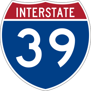
Interstate 39 (I-39) is a highway in the Midwestern United States. I-39 runs from Normal, Illinois, at I-55 to State Trunk Highway 29 (WIS 29) in the town of Rib Mountain, Wisconsin, which is approximately six miles (9.7 km) south of Wausau. I-39 was designed to replace U.S. Route 51 (US 51), which, in the early 1980s, was one of the busiest two-lane highways in the United States. I-39 was built in the 1980s and 1990s.

<span class="mw-page-title-main">Illinois Route 5</span> State highway in Rock Island County, Illinois, United States

Illinois Route 5 (IL 5) is a four to six lane state highway in Rock Island County, Illinois, United States, that runs from U.S. Route 67 (US 67) in Rock Island to the interchange of Interstate 80 (I-80) and the toll-free portion of I-88, a distance of 15.78 miles (25.40 km). IL 92 also continues eastbound on I-88.

<span class="mw-page-title-main">Interstate 88 (Illinois)</span> Tolled Interstate in Illinois

Interstate 88 (I-88) is an Interstate Highway in the US state of Illinois that runs from an interchange with I-80 near Silvis and Moline to an interchange with I-290 and I-294 in Hillside, near Chicago. I-88 is 140.60 miles (226.27 km) long. This route is not contiguous with I-88 in New York. Since 2010, most of I-88 has been part of the Chicago–Kansas City Expressway. The highway also runs through the cities of Aurora, Naperville, DeKalb, and Dixon. East of Rock Falls, the route is a part of the Illinois Tollway system.

<span class="mw-page-title-main">State highways in Oregon</span> Highway system of Oregon in the United States

The state highway system of the U.S. state of Oregon is a network of highways that are owned and maintained by the Highway Division of the Oregon Department of Transportation (ODOT).

The South Carolina State Highway System is the fourth largest state-maintained system of state highways in the country. It consists of Interstates, U.S. highways, state highways, and secondary roads, totaling approximately 41,500 miles (66,800 km).

<span class="mw-page-title-main">Illinois Route 126</span>

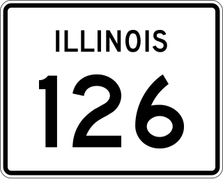
Illinois Route 126 (IL 126) is a 17.25-mile-long (27.76 km) east–west state highway in the northern part of the U.S. state of Illinois. It travels from IL 47 in Yorkville to Interstate 55 (I-55) between Plainfield and Bolingbrook.

<span class="mw-page-title-main">Illinois Route 140</span>

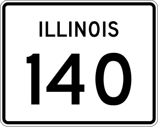
Illinois Route 140 is a 52.05-mile-long (83.77 km) east–west highway with its western terminus at Illinois Route 143 in Alton and its eastern terminus at U.S. Route 40 near Mulberry Grove. It also overlaps IL 111 in Alton and IL 127 in Greenville.

<span class="mw-page-title-main">Texas state highway system</span> Highway system of Texas in the United States

Texas state highways are a network of highways owned and maintained by the U.S. state of Texas. The Texas Department of Transportation (TxDOT) is the state agency responsible for the day-to-day operations and maintenance of the system. Texas has the largest state highway system, followed closely by North Carolina's state highway system. In addition to the nationally numbered Interstate Highways and U.S. Highways, the highway system consists of a main network of state highways, loops, spurs, and beltways that provide local access to the other highways. The system also includes a large network of farm to market roads that connect rural areas of the state with urban areas and the rest of the state highway system. The state also owns and maintains some park and recreational roads located near and within state and national parks, as well as recreational areas. All state highways, regardless of classification, are paved roads. The Old San Antonio Road, also known as the El Camino Real, is the oldest highway in the United States, first being blazed in 1691. The length of the highways varies from US 83's 893.4 miles (1,437.8 km) inside the state borders to Spur 200 at just 0.05 miles long.

<span class="mw-page-title-main">Interstate 80 in Illinois</span> Highway in Illinois

Interstate 80 (I-80) is a part of the Interstate Highway System that runs from San Francisco, California, to Teaneck, New Jersey. I-80 enters Illinois from Iowa in the west, southwest of Rapids City, and runs generally eastward through East Moline, LaSalle, and Joliet, before entering Indiana in Lansing. The Interstate runs for approximately 163.52 miles (263.16 km) through the state.

<span class="mw-page-title-main">Interstate 94 in Indiana</span> Section of Interstate Highway in Lake, Porter, and LaPorte counties in Indiana, United States

Interstate 94 (I-94) is a part of the Interstate Highway System that runs from Billings, Montana, to Port Huron, Michigan. I-94 enters Indiana from Illinois in the west, in Munster, and runs generally eastward through Hammond, Gary, and Portage, before entering Michigan northeast of Michigan City. The Interstate runs for approximately 45.8 miles (73.7 km) through the state. The landscape traversed by I-94 includes urban areas of Northwest Indiana, wooded areas, and farmland. The section of I-94 between the Illinois state line and Lake Station is named the Frank Borman Expressway.

<span class="mw-page-title-main">Interstate 90 in Illinois</span> Section of Interstate Highway in Illinois, United States

Interstate 90 (I-90) in the US state of Illinois runs roughly northwest-to-southeast through the northern part of the state. From the Wisconsin state line at South Beloit, it heads south to Rockford before heading east-southeast to the Indiana state line at Chicago. I-90 traverses 124 miles (200 km) through a variety of settings, from farmland west of the Fox River Valley through the medium-density suburbs west of O'Hare International Airport, through Downtown Chicago, and through the heart of the industrial southeast side of Chicago before entering Indiana.

<span class="mw-page-title-main">U.S. Route 41 in Illinois</span>

U.S. Route 41 (US 41) in the U.S. state of Illinois runs north from the Indiana border beneath the Chicago Skyway on Indianapolis Boulevard to the Wisconsin border north of the northern terminus of the Tri-State Tollway with Interstate 94. It is the only north–south U.S. Route to travel through a significant portion of the city of Chicago, carrying Lake Shore Drive through the central portion of the city along the lakefront. US 41 in Illinois is 64.81 miles (104.30 km) in length.

<span class="mw-page-title-main">California postmile</span> Location marking system on highways in California, US

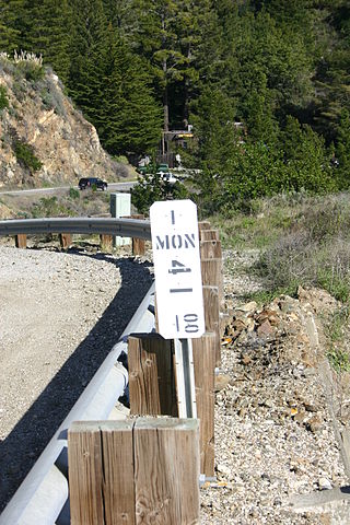
California uses a postmile highway location marker system on all of its state highways, including U.S. Routes and Interstate Highways. The postmile markers indicate the distance a route travels through individual counties, as opposed to milestones that indicate the distance traveled through a state. The postmile system is the only route reference system used by the California Department of Transportation (Caltrans). The system was operative by 1966.

<span class="mw-page-title-main">Pennsylvania State Route System</span> Highway system of Pennsylvania in the United States

In the U.S. state of Pennsylvania, state highways are generally maintained by the Pennsylvania Department of Transportation (PennDOT). Each is assigned a four-digit State Route (SR) number in the present Location Referencing System. Traffic Routes are signed as Interstate Highways, U.S. Routes and Pennsylvania Routes, and are prefixed with one to three zeroes to give a four-digit number. PA Routes are also called Pennsylvania Traffic Routes, and formerly State Highway Routes.

<span class="mw-page-title-main">Illinois State Highway System</span> Highway system in Illinois, United States

The organized State Highway System of the U.S. state of Illinois comprises all of the state routes in the state.

References

  1. McNichol, Dan (2006). The Roads that Built America. New York: Sterling. p. 74. ISBN   1-4027-3468-9.
  2. Illinois Technology Transfer Center (2007). "T2 GIS Data". Illinois Department of Transportation. Archived from the original on August 10, 2007. Retrieved November 8, 2007.